|
Colorado's Historic High Line Canal
Photos and Text by Dave Parsons (unless otherwise noted)

In 1883, the Northern Colorado Irrigation Company and its subsidiary the Platte Land Company (incorporated in 1879) completed the 71 miles of the High Line Canal after three years of construction. Starting near the mouth of the South Platte River, the canal, ditches and smaller laterals snaked 82 miles. Formed by British land developers/capitalists to profit from settlers heading west, the Platte Land Company and it's Platte Canal were often referred to as the English Ditch or the English High Line. The canal's descending construction with a gradual elevation drop refers to the engineering principle of "High Line," and as time progressed the canal just became the High Line Canal (The name is not unique as there are other High Line Canals in Colorado).
The photographic cabinet card advertised some of these newly watered lands stating "Irrigation in Colorado gives a security to the farmer, and a control over the results of his labor..." and "100,000 acres of rich lands are offered for sale under this canal by The Platte Land Company (Limited)" at 456 Larimar Street in Denver.
The photo is very similar to William Henry Jackson's photo below. (from ebay photo) |

Emerging onto the plains, the South Platte River exits the canyon walls of Waterton Canyon on March 29, 2012. The start of the High Line Canal begins at the intake tunnel and dam, about a mile and a half up the canyon. Historical structures dot the landscape at the mouth of the canyon. (Parsons photo) |

Snaking through the Front Range Rocky Mountains, the South Platte River provides drinking water for many of the Denver neighborhoods. The High Line Canal diversion and dam are at the bottom of the photo in September of 2020. (Parsons photo) |

In July of 1820 during the Long Expedition, Samuel Seymour sketched out the Platte River as it emerged onto the plains of Colorado from today's Waterton Canyon and Kassler. The jagged cliff wall in the center of the lithograph would be tunneled through at the start of the High Line Canal decades later. (Photo from online book sale listing - Account of an Expedition from Pittsburgh to the Rocky Mountains, performed in the years 1819, 1820. Book also in Library of Congress) |

Almost fifty years later, Alfred Edward Mathews in the late 1860s sketched the same location but from further east. (Parsons photo of lithograph from Littleton Museum exhibit in August of 2007) |

A few years later, a new technology, photography, is implemented in recording the Platte River. William Henry Jackson's 1873 stereoview photo with the Hayden Survey showed the Platte River as it emerged from the Colorado Rocky Mountains. At the same location, the river would be tapped a decade later providing irrigation water for crops across the Front Range.
150 years later the area looks much the same with the walls of the Platte Canyon Reservoir on the left and the buildings of Lockheed Martin on the right and electrical towers running through the middle. (Ed & Nancy Bathke Collection and Parsons Photo) |

A year later in 1874, William Chamberlain photographed the Platte River, after the Denver and South Park Railroad had been constructed climbing up the canyon. At the same time, local settlers were constructing a variety of irrigation ditches downstream using the local rivers. Likewise, business interests saw the potential of the Platte. (Dave Parsons Collection) |

In 1880, Denver's Rocky Mountain News published an article describing the construction of the High Line Canal. The canal would be completed in 1883. (Article from Colorado Historic Newspapers) |

In 1888, the Plat of Portion of Water District no. 8 was published, showing the snaking High Line Canal, also known as the The Northern Irrigation Company Canal. (Map from Denver Public Library) |

Ten years after his Hayden Survey photos, William Henry Jackson took more photos, this time of the High Line Canal emerging from the hogback about 1883 after the completion of construction. In typical fashion, Jackson placed two small figures at strategic locations for an easily recognizable size comparison. (Parsons Collection) |

At the mouth of the Platte Canyon, Kassler's slow sand filter beds and the Platte Canyon Reservoir take up much of the flat, open space. The High Line Canal flows off the lower right corner and follows the tree line along the horizon. Today, the filter beds have been filled in and covered up. (September 1918 Denver Municipal Facts - Denver Public Library Digital Collections) |

Old water maintenance buildings from the early 1900's remain at the mouth of Waterton Canyon at Kassler in 2022. (Parsons photo) |

Kassler Filter Plant sign hanging on the side of one of the maintenance buildings. (Parsons photo) |


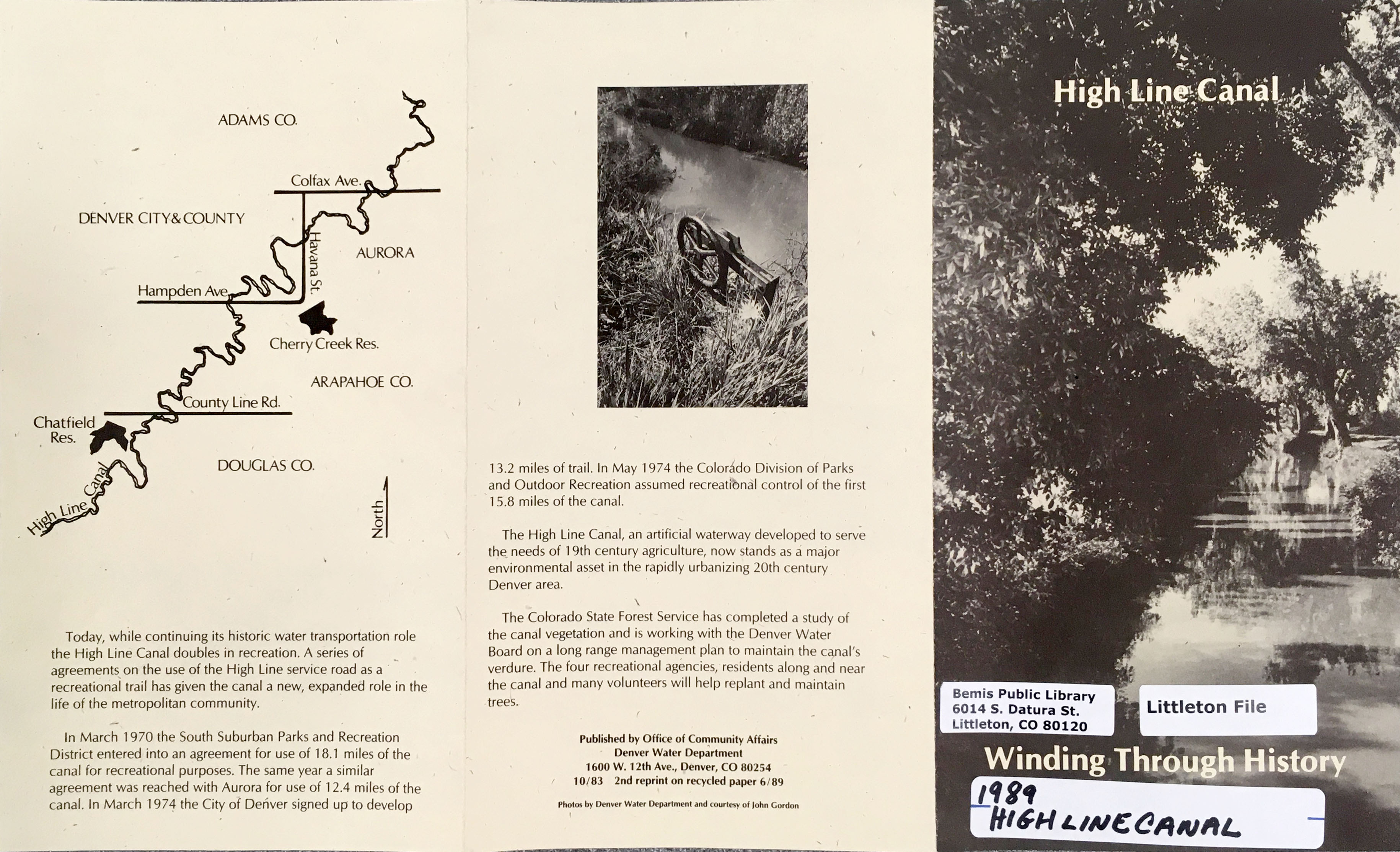
A High Line Canal publication, originally published in 1983, shows a map of the snaking canal as it weaves through the various Colorado counties. The publication also provides a useful history of the canal, completed in 1883. (Pamphlet housed in the Littleton files of the Bemis Public Library.) |

Another 1983 map shows Waterton Canyon and the start of the canal. (Pamphlet housed in the Littleton files of the Bemis Public Library.) |
 
In December, 2023, the river water is low where the intake dam is located and has been improved in recent years. Just the top of the tunnel through the mountain can been seen in the cliff face left of the shack.
In 2020, water flows down the Platte River, but not in the cement canal heading east toward the Platte Canyon Reservoir. Visitors walk and bike along the popular Waterton Canyon road way as overhead pipes divert water to Lake Marston in Lakewood. (Parsons photos) |

Waking on top of the cement canal wall, a mother black bear leads her cubs eastwards down Waterton Canyon in August of 2015. (Parsons photo) |

In the summer of 2004, the canal is dry as it passed by the hogback along the Front Range foothills adjacent to the Platte Canyon Reservoir. A few years later, the green open area at the base of the foothills would host a controversial housing development overlooking Waterton Canyon. As usual, water for the development would also be a troublesome issue. (Parsons photo) |

Recently, in the wet year of 2023, beavers have ventured into the canal, constructing a pair of dams and slowing the flow of water. This stretch along the Platte Canyon Reservoir holds water backed up by the beaver dams. The remaining areas of the canal are mostly bone dry. (Parsons photo) |

Recreation is the primary use of the High Line Canal today. Water occasionally passes through the canal to water nearby cemeteries, however most of the agricultural farms have found other water sources. Today, the highly inefficient canal is too vulnerable to leaking, deteriorating walls, evaporation and overgrown shrubs and trees. Just down from the beaver dams, The Miksch-Helmer Cabin constructed in the 1870s still sits along the canal as a couple walk past in December of 2023. (Parsons photo) |

Another William Henry Jackson photo of the High Line Canal, showed the flume over Plum Creek. Notice the three people standing at the base of the supports on the ice. The redwood flume measured 918 feet and was the longest flume on the canal. (Parsons Collection) |

The more publicized flume photo of William Henry Jackson showed a more dynamic angle of the High Line Canal over Plum Creek. Notice the carriage and horseback rider near the creek and the man sitting on the flume itself. (Parsons Collection) |

In a 1937 aerial photo, the Plum Creek flume, the dark, straight lines in the middle of the photo, crosses the winding Plum Creek. Both the Denver and Rio Grande Rail Road and the Atchison, Topeka and Sante Fe Rail Road as well as the Santa Fe highway with tiny vehicles cut vertically through the right of the photo. Titan Road, still a dirt road, cuts across the bottom. Today the flume is gone, washed away after the 1965 flood. Water is now directed underground through a gravity siphon. Stockton's Plum Creek Stables on Titan has not yet arrived near the creek. Tiny hay bales dot the open fields. (photo from Douglas County Digital Archives). |

In the fall of 1988, a trio of Santa Fe engines pulled a mixed train along the Denver and Rio Grande Rail Road along the edge of the canal, once again lined with huge cottonwoods overlooking Chatfield Reservoir. (Parsons photo) |

Tall cottonwood trees lined the canal in the summer of 1986 near County Line Road. The trees would housed many families of great horned owls and the areas near the canal would support a wide array of wildlife. (Parsons photo) |

Between Dry Creek and Mineral Avenue, the Lee Gulch trail intersected the canal flume in August of 2005. (Parsons photo) |

Map of canal in Littleton and the South Suburban Metropolitan Recreation and Park District. |

In 2005, At DeKoevend Park in Littleton, the Big Dry Creek merged with the canal and open gates let the water continue down the creek bed. Close the gates and water continued northwards down the canal. Bikers ride next to the canal in the distance. A trail follows the creek from the nearby Cherry Knolls Park, where I would play goalie during soccer games as a kid in the 1970s and under East Arapahoe Road and South University Blvd. This park route was my path to long distance bike rides on the canal trail and to tennis matches (at the courts on the left in the photo) in the 1980s. (Parsons photo) |

In May of 1999, a family of foxes nursed, played, gathered food and lived in the undeveloped scrub area along the canal at the north end of DeKoevend Park in Littleton. The canal trail was a great place to watch the foxes, night herons and nesting great horned owls. (Parsons photos) |

In May of 1998, horses watch the nearby fox family in DeKoevend Park in Littleton. (Parsons photo) |

Also along DeKoevend Park in Littleton, edible oyster mushrooms enjoy the rotting roots of an old dead cottonwood along the canal path. (Parsons photo) |

On May 9, 1998, runners enjoy a race on a cool morning through the DeKoevend Park path lined with huge old cottonwoods and new green grass. (Parsons photo) |
DP Home | Feature | Gallery | About
|