Mount Morrison Cable Incline (Funicular) Railway
Photos and text by Dave Parsons
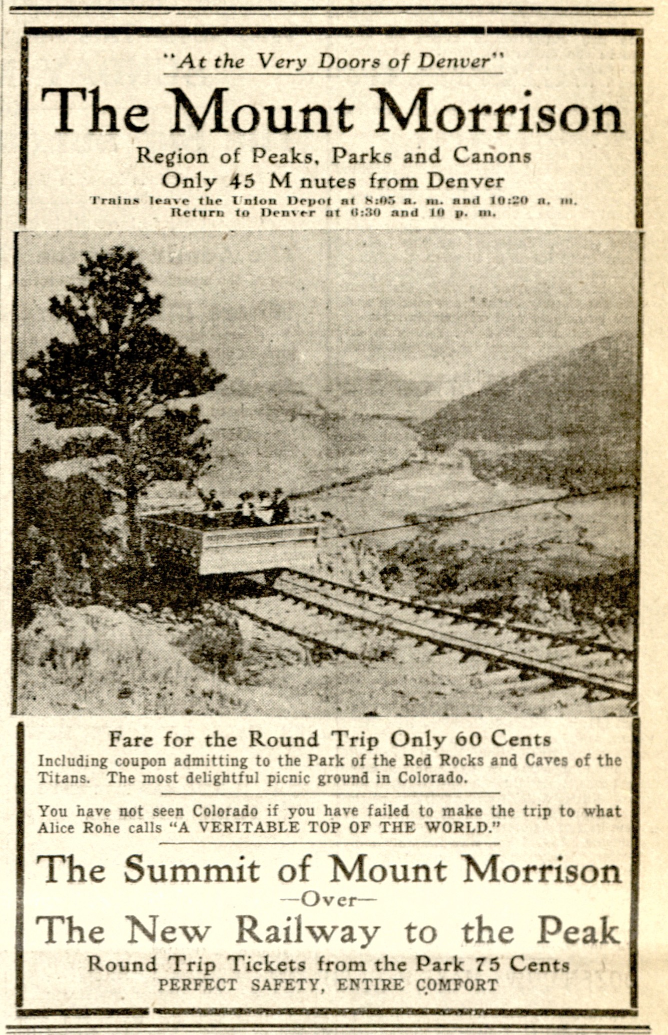
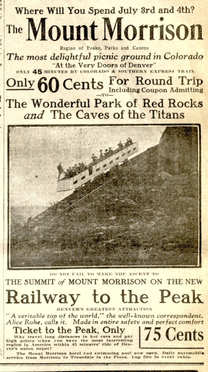
60 cents for a round trip ride to the top of the mountain with "The most substantially constructed and equipped incline railway in the world. Safer than a hotel elevator. Eleven large sheaves, six of them eleven feet high, control the cable." Pamphlet from Parsons Collection.
In June of 1976, the entire family hikes up Mount Morrison overlooking Red Rocks Park and Amphitheater. Near the top of the mountain, I'm standing on the far left, missing a front tooth and in my uncomfortable and too short pair of (floods) "Toughskins" with my brother and mom. (Bob Parsons photo)
In the 1970's, hiking steep mountainsides in my torn up and loose fitting tennis shoes with long, (and immensely disliked) Sears "Toughskin" pants protecting my legs from scratching twigs was a part of growing up in Colorado. We would walk across high, rickety wooden train trestles, through mountain passes in and around old decrepit train cars searching for old rusty bits of history left behind from a different world. In 1976, this wanderlust led our family to hike up and down the rocky boulder strewn routes up Mount Morrison exploring the path gouged through granite for the old cable driven funicular route built in 1908.
Morrison Incline map from Tracking Ghost Railroads in Colorado complete with the dates the family hiked and found spikes on the grade and the nearby Colorado and Southern grade near the Soda Lakes.
Having arrived in Colorado in the late 1960s, my parents had to explore their new territory and that usually involved dragging us kids on many old overgrown hiking and biking paths, steep mountains, dirt roads and old torn up railroad grades. After a few years, we acquired Robert Ormes book "Tracking Ghost Railroads in Colorado" which opened up whole new territories including the Morrison and Red Rocks area. Following the hand drawn maps we set off to the small town Morrison. The approach was easy in the 1970s; drive up the Bear Creek valley on the old highway 285, to and through Morrison and turn off the first right to Red Rocks Amphitheater and then, park and walk straight up the steep railroad grade. Today, highway C-470 provides rapid access to the Mount Morrison Trail, which runs 1.7 miles along the ridge, now part of the Mathews-Winters trail system, complete with its own parking lot and even a trailhead map showing the route from the base to the summit.
Starting at the base heading west, climbers pass thorough jagged rocks and loose dirt on an initially steep stretch, but the trail eases off and follows old power lines, some of which are literally stretched out over the ground. Junipers, mountain mahogany, prickly pear cactus and yuccas line the ever widening and eroding trail. Kestrels enjoy using the power lines and poles as lookouts while hunting. During the spring, Lazuli buntings and black-headed grosbeaks also enjoy the area. In all seasons mule deer traverse the hillsides regularly, browsing through the many shrubs.
At water stops, a distant Green Mountain, downtown Denver, the nearby Red Rocks, town of Morrison and Mount Falcon make for great views. The distinctive sloped hogback runs like a backbone for miles north and south along the Front Range connecting the plains to the Rocky Mountains. Looking eastwards again, growing housing developments sprout like weeds across from the Soda Lakes. Down in Bear Creek Canyon, an increasing volume of traffic winds through the curves. In recent years, trail use has also increased on this and all the nearby trails, especially after Covid-19, as more people have discovered the outdoors.
In a snobbish 1908 pamphlet appealing to the wealthy, the pages tout the benefits of the Morrison area "For people of means and leisure who seek interesting environment, perfect water, cool nights, smokeless skies and ideally healthful conditions." and "THE MOST HEALTHFUL SPOT IN THE AMERICAN CONTINENT - A WONDERLAND OF PARKS PEAKS CANYONS & CAVES - THE PARK OF THE RED ROCKS - THE CAVES OF THE TITANS." From Parsons Collection
Snow carpets the ground in the shade around Colorow Cave in 2001, a long time Native shelter and gathering place just south of Red Rocks and part of the same red colored Fountain Formation.
But, the area in and around Morrison has always been a popular location. For thousands of years Native Americans once enjoyed the spring waters at what is now Rooney Ranch, sheltered in Colorow Cave and discovered the natural acoustics of Red Rocks. Bear and Mount Vernon Creeks have long been sources of water and wood, feeding cottonwood tree fires and thirsty tribes. Tipi rings left from native camps once dotted the area and their archaeological site locations were like ancient neighborhoods distributed among the various Fountain Formations and hogbacks from the Apex trail in the north to Ken Caryl and Roxborough State Park in the south. Sites like Lodaiska, Magic Mountain, Cherry Gulch and the Swallow site have been used over many millennia and some have been dated to well over 9,000 years old.
Recently, as European immigrants filtered into the area they too discovered the uniqueness and natural beauty of the area. They made their homes in the area as well, but also looked to extract what mother nature had provided. Timber was harvested from the numerous forests as horse and mule drawn wagons full of milled boards rolled down Bear Creek Canyon into Morrison. Stone and red rock were dug out of the hogbacks for construction material as numerous fiery, high temperature stone kilns filled with burning coal converted or "calcined" limestone rock into quick lime for various industrial uses. River courses were dug, divided and channeled across miles of prairie to irrigate crops. Clay and coal for fuel and bricks were also mined nearby and shipped via rail to Denver. Even dinosaur bones were excavated out of the hogback overlooking the town to be displayed in eastern university museums. Only later, would tourism become the predominate source of extraction.
In the late 1890s, the town of Morrison became a resort or destination town advertising for a hour long train trip out of Denver to visit the spectacular formations of the "Garden of the Angles (1870)," later renamed the "Garden of the Titans (1906)" and later still, Red Rocks Park.
John Brisbane Walker looks out from his home on Mount Falcon down the Bear Creek Canyon "From the window one could look into a canyon more than 1,500 feet down." (from book: Indian Hills) Mount Morrison rises in the background. The home would later burn down in 1918. Photo from the "Denver Municipal Facts" (mislabeled 1910 caption) - Denver Public Library Digital Collections
In a snobbish 1908 pamphlet appealing to the wealthy, the Mount Morrison area was:
"For people of means and leisure who seek interesting environment, perfect water, cool nights, smokeless skies and ideally healthful conditions."
"A second Colorado Springs to be within half an hour of Denver’s stores, churches, school and theaters. A summer or winter home near enough to get to early business in Denver; the Mount Morrison Casino as a social center; a dozen beautiful drives to delightful mountain parks and canyons."
The cold, shady waters of Bear Creek were filled with trout ready to be fished out on a hot summer’s day. Hike though the harrowing "Cave of Seven Ladders" in the red rocks. Afterwards, take the incline railway up to the top of the mountain for more spectacular views and later stay at the luxury hotel on the hill for an evening of dining, dancing and gambling. To make this happen, an enterprising John Brisbane Walker, a motivated businessman from New York with big ideas and impressed with the "extraordinary advantages of climate, health and environment offered by Mount Morrison" worked to build Morrison and Red Rocks as the destination spot for Colorado close to Denver while competing directly with the long established hot spot of Colorado Springs and its "Garden of the Gods."
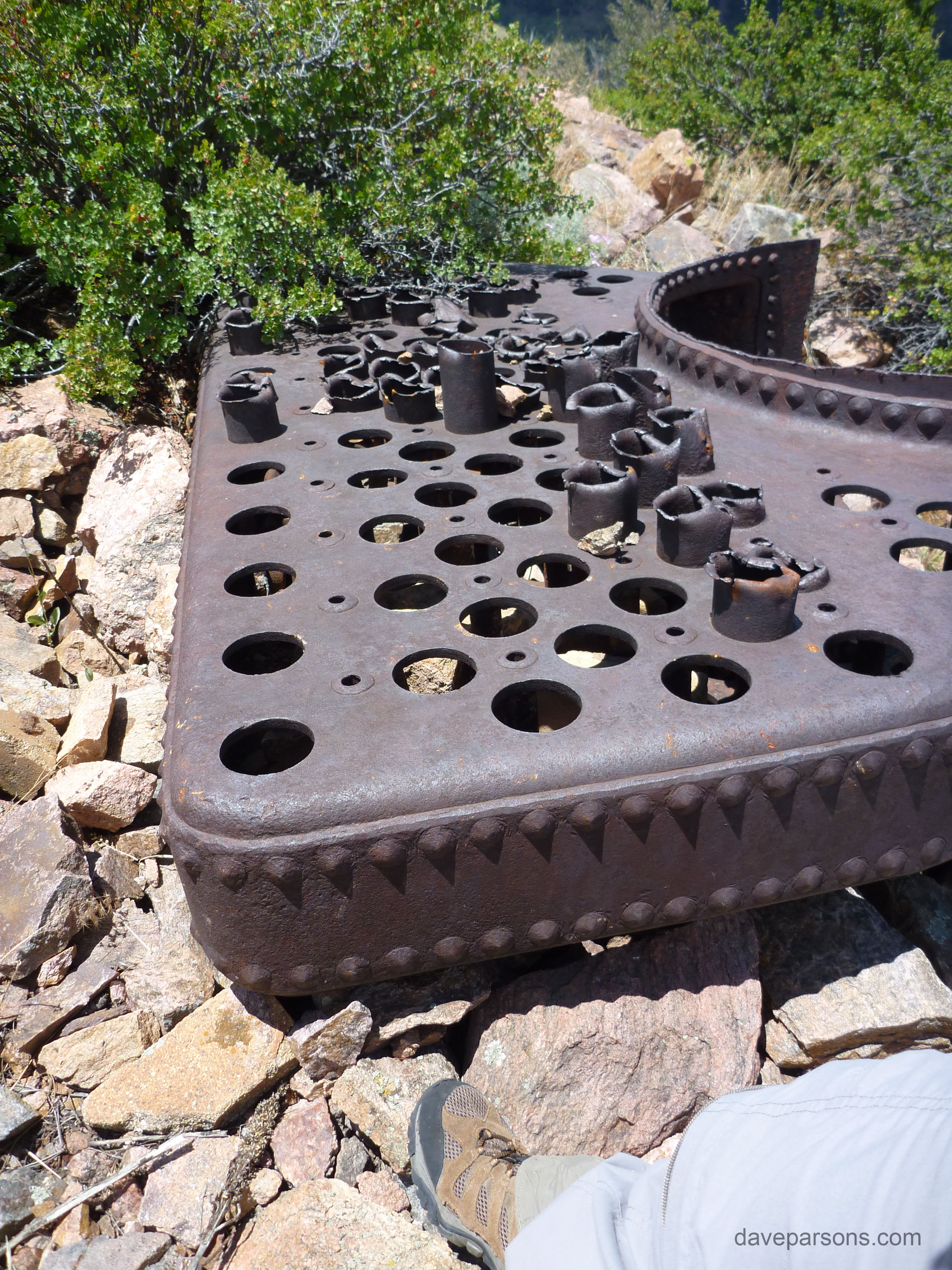
July 30, 2013 - Near the top of Mount Morrison, my father, Bob Parsons stands on a concrete foundation near where rusty steam engine parts remain in a area that once housed the steam boiler and massive 8 foot wide, grooved driving sheaves that once propelled the rail cars. (As of July 8, 2024 the foundations still remain, but the steam boiler and other parts are no longer there.)
Continuing along the trail, a snow covered Mount Blue Sky (old Mount Evans) becomes visible as the trail turns to the northwards and scrambles over some jagged outcrops. The path stretches out directly over the amphitheater and begins to climb over more rock. Steep granite faces require good balance and a bit of scrambling to get to the top. Once there, a 360 degree view rewards the hiker. Look more closely and a cement platform and rusty metal bits are nestled among the sharp granite boulders. Railroad rails and wooden ties with spikes still pounded in them remain where they were slid down the mountain over a 100 years ago after the railway fell into disrepair. Move towards the east and large piles of graded rock make up the most impressive remains of Walker’s incline railway.
Throughout 1907 and 1908, Walker, with help from workers from the town of Morrison and Denver built a incline steam railroad, a labor intensive project, up the face of Mt. Morrison. "From October 1, 1907, to April 6, 1908, workmen were engaged in blasting and digging on the exposed face of Mount Morrison, for the new "Railway to the Peak." A couple of months later, local Morrison residents "Manley Sawyer and Tom Matthews are engaged in hauling rails to the Mount Morrison Incline railroad this week." (May 30, 1908 Jefferson County Graphic)
According to the Jefferson County Graphic on June 30, 1908:
"Over 25 men are now employed on the Mt. Morrison Incline railroad and the work is being rapidly pushed toward completion. About 1000 feet of the road grade is complete, ready for the rail and ties, and a few feet of tracks has already been laid. The roadbed for the remainder of the distance is partially graded. One cannot imagine the enormity of such an undertaking without viewing the scene of operations and it is well worth your while to take a walk over the steep incline, which is to become one of Colorado's greatest achievements in railroad engineering."
Part of the old, specially engineered six strand, 19 wire cable found below the railway grade in the rocks that was once 10,000 feet in length. For years, the two cars would have been pulled up and down by this cable. Today, only broken and rusty pieces remain.
Advertisements promoted it as "The Most Wonderful Mountain Incline Railroad in the World." Yet, construction was formidable as rail safety was paramount and required engineering precision. According to the April 30, 1908 Telluride Journal, the incline needed:
"One of the largest contracts for cables ever made in this state." A cable length "10,000 feet, an inch and a quarter in diameter was ordered for use on the Mount Morrison Incline Railway… This cable which will be specially drawn and tested, will be shipped from the eastern factory by May 25 and will be in position in ample time for the opening of the incline railway on July 4. The cable will have a breaking strain of sixty-seven tons to each strand, more then twenty times the weight to which it will be subjected."
1908 incline construction with a horse and carriage at the base of the tracks where the rails are still being laid on the ties. (Photo tinted by author. Original photo courtesy Dvr. Pub. Library, Western Hist. Dept.)
The article continued:
"This road will be the longest incline railway in the country, its entire length being 4,800 feet. In some places in its ascent to the top of Mount Morrison the road will have a maximum grade of 60 per cent."
"When finished it will prove one of the most remarkable feats of engineering to be found any place in the Rockies."
Engineering News of October 26, 1911 described the incline having "a track gauge of 5 ft. 4 ins. to allow of using wide cars, which carry 100 passengers. There are three rails, so as to avoid the use of frogs at the half-way passing places." The cables were also described as "two in number 1 1/4 ins. in diameter; each having six strands of 19 wires of specially drawn crucible steel." The cables were super strong, but also super heavy and according to a April 18, 1908 Rocky Mountain News article, the "builders of the incline road are confronted with the problem of transporting the immense cables for the road from the railroad station to the mountain side as these weigh several tons - this is no small task." Moving the cable would have painted quite the picture with the heavy cable stringing out over the hills and rocks, likely being pulled by numerous teams of horses and mules throughout the red rocks.
The two open air cars, painted white with "delicate shades of yellow and black" trim each held 80 passengers and counterbalanced each other as a pair of powerful reversing steam hoists and a steam boiler pulled one car up to the top while the other descended to the bottom. The seats in the wide cars swung on pivots to keep the rider level as the cars ascended the ups and downs while climbing and descending the mountain. The Jefferson County Graphic reported on July 11, 1908, "A 125 horse power boiler and an engine of the same capacity are now on the ground, ready to be placed for the Mt. Morrison Incline railroad." Six, huge 8 feet wide driving sheaves or grooved wheels guided and drove the cables via massive gears on a 10 foot wide 10 inch diameter axle shaft. An engineman operated the powerful post brakes to control the speed of the cars as ten thousand pounds of cable passed over the mountain top supports.
Much of the incline heavy equipment including the braking system was manufactured by the Vulcan Iron Works of Denver and Hendrie & Bolthoff Mfg. and Supply Co.
But like many railroads of the time, delays were inevitable and the opening date was not to be met. The original date was planned on July 4, 1908, but over a month later, according to the August 15, 1908 Jefferson County Graphic, "The last of the machinery for the Mt. Morrison Incline Railway arrived last week... Not until the road is completed will people understand the enormity of the undertaking, or the great importance of the new attraction to Morrison."
According to the Rocky Mountain News, on August 7, 1929, Governor John F. Shafroth along with other guests, were to attend the opening of the Mt. Morrison Railway.
Finally, almost a year later on August 7, 1909, John Brisbane Walker along with Governor Shafroth and hundreds of spectators christened the Mt. Morrison Incline Railway on its "maiden voyage to the stars." The 25 minute trip led to a mountain top observation platform, a refreshment stand and even a dance pavilion.
On the afternoon on September 5, 1909, the public was invited to ascended the mountain and travel through a low bank of fog and emerge into the sun to the delight of all. The incline would also operate in the winter according to a September 8, 1909 newspaper report where Walker stated "snow melts as rapidly as it falls."
After the opening, newspaper ads promoted the incline and another tourism pamphlet promoted the railway after construction stating, "The new road just opened by John Brisben Walker up Morrison, bringing the work of two years to a successful finish, has given to Colorado one of the wonders of the modern world..."
The pamphlet described the new route and its
"wonders of the mountain pictures, unfurling with the changes and splendor of a moving panorama as you make that wonderful ascent up- up into the air, clinging involuntarily with that moving car to the mountain side, make you gasp at the daring that has placed this wonderful incline railway with its powerful and intricate machinery in the very midst of rugged and primeval nature, lording over the massive shape of Titan caves and upheavals, glinting in the red distorted sandstone in the Park of the titans below."
The distinctive three rail trackway and wide passenger car ready to ascend the mountain in a 1910 post card. From Parsons Collection
After running almost a year, the May 29, 1910 Rocky Mountain News wrote:
"for the first time in history a band today will ascend Mt. Morrison via the inclined funicular railway at the Park of the Red Rocks, near Morrison."
"Strange indeed will the combination of music poured forth from the instruments of a good sized band far up in the rugged wildness of the famous old mountain from which the first survey of Denver and this region was made."
"The band will leave Denver at 8:05 o’clock this morning over the Colorado & Southern and will give several brief concerts during the day, one of them being from the platform at the peak of Creation Rock and another upon the summit of Mt. Morrison, 2,000 feet above the level of the plains and the rocks in the valley below."
Unfortunately, in 1914, Walker's mountain top pavilion met the same fate as his Mt. Falcon home and went up in flames and soon after in 1915, the incline made its last trip to the summit (2006 Historically Jeffco).
Despite the time, expense, materials and effort used in construction and numerous newspaper and pamphlet promotions, the incline seemed to have a rather short life. After running only six years it must of lost its appeal. At the same time, it was also competing with the nearby Lookout Mountain and Golden funiculars, which also closed around 1915. As automobiles increased in popularity, more mountain roads were being built (including through the middle of Red Rocks) and the Mount Morrison incline laid idle through the 1920’s. In 1929, the city of Denver acquired Red Rocks with its incline railroad and attempted to sell it for scrap. The Rocky Mountain News April 6, 1929 reported:
In 1925, much of the incline hardware remained including the massive sheaves. Photo from Memory Album Morrison, Colorado.
"Denver Stuck With Railroad - Cant Sell it at Profit, So May Hang on to it for While: The city of Denver owns a railroad. It doesn’t particularly want it. But it can’t sell it at a profit. So it may keep it, tear it to pieces and repair bridges, motor trucks, autos and fire engines with it."
"The Railroad about a mile in length is the old funicular steam road up Mount Morrison, acquired by the city with its purchase of the Park of the Red Rocks a year ago. The property includes 6,900 feet of 60-pound steel rail, 7,900 feet of 40-pound rail, two steam hoists and a steam boiler."
"Wrecking the old railroad, a show attraction for the horseless carriage age of 25 years ago, is preliminary to improving the park this season."
Eventually the city scrapped the rails for $570. (2006 Historically Jeffco)
It seems the advent of the automobile was the death knell for the incline railway in the "horseless carriage age," as now people could drive in their own private vehicle to the top of the mountain. The same, lack of interest over time occurred in the other two nearby incline railways, the Lookout Mountain funicular and Golden’s Castle Rock funicular. However, the cog railway up Pikes Peak in Colorado Springs still endures to this day.
In 1976, our entire family hiked up the mountain on a June day. A concrete platform still sits on a lonely precipice overlooking much of the Front Range. Broken stretches of heavy rail, ties and a rocky grade remained then, much as today. Rusty chunks of the boiler and broken sheaves with its characteristic grooves sit in rocky crevices far from their complete former glory. Hikers and trail runners ascend the mountain and a road leads to the top for workers maintaining the cell tower and antennas. Having made the climb numerous times, the views and history still make for a wonderful trip through nature and time.
Colorado and Southern ad in the 1910 Rocky Mountain News - "Morrison and Park of Red Rocks 60 cents" and "Morrison including Park of the Red Rocks and Incline Railway to Summit, $2.00" - Ad from Colorado Historic Newspapers Collection.
West of the hogback the railway climbed Mount Morrison. 1923 topographical map from the USGS Topoview
Part of the steam engine cam shaft or piston and just west of the amphitheater, the two car incline started in between massive red rocks and climbed the mountain straight up. Parsons photos.
On July 29, 2013, railroad rails slide down the side of the mountain under the built up grade of broken up granite. The massive amount of work to build the grade employed many residents of the town of Morrison. Parsons photos.
On the same day, railroad ties with spikes pounded in still remain discarded off the side of the stony railroad grade. Parsons photos.
Part of the massive geared wheel or sheave guiding the thick cables on top of the mountain remain battered and broken on the mountainside. Other unidentifiable parts remain littered in the rocks. Parsons photos.
Parts of the steam engine are quite large compared to a person. A drive shaft sits also sits on the top of the mountain. Parsons photos.
Part of the braking system for the incline manufactured by the Vulcan Iron Works in Denver was being moved on June 25, 2018 to the maintenance sheds near Morrison Park. The pull levers have the same design as the levers driving the sheaves. Vulcan is in raised lettering on the axle mount.
Parts of the braking system for the incline manufactured by the Vulcan Iron Works in Denver and some type of axle mount we found along the grade in 1976 with raised lettering, "DILLON - BOX DENVER." Another smaller mount also sits next to the Dillon mount.
Near the base of the funicular, the bandstand or deck can be seen on top of Creation Rock as the tracks head uphill. Photo from the Denver Municipal Facts - Denver Public Library Digital Collections
Some of the loose spikes we picked up back in 1976 from the side of the grade now in the Jefferson County Archives. The spikes were once pounded into the wooden ties to hold down the long steel rails like the ones in the left photo. - Parsons photo.
In 1925, the incline had fallen out of favor and was more of a curiosity from the past. Photo from Memory Album Morrison, Colorado.
Filled in with snow, a scar from the grade can be seen from a distance climbing to the top of the mountain from Red Rocks with Bandimere Speedway below on March 6, 2015. - Parsons photo.
Wide train cars accommodated crowds of people and the steam boiler with two sets of sheaves firmly held in position on the mountain top.
Photos from pamphlet "The View From Mt. Morrison - A Story of a Colorado Town" and tinted by author - Original photo courtesy Dvr. Pub. Library, Western Hist. Dept.)
Comparing the manufacturing designs on the various components of the incline braking system and the sheave drivers. Parsons photo and Jefferson County Digital Archives photo.
Mount Morrison tourism pamphlet dating from about 1909 - Parsons collection
Morrison development/tourism pamphlet from 1908, made during the construction of the incline. Parsons collection
In June of 1976, Bob photographed an immovable, large and heavy duty cable guide wheel lower down on the grade.
July 8, 2024 - In the scree field below the grade near the summit, a two foot diameter cable support wheel weighing well over a hundred pounds remains lodged in the rocks with other parts rolled off from above.
Today, the trail to the top is a braided mess of weaving paths. Chain link steps have been added to try and reduce erosion, yet it's steep, rocky and easy to slide down the eroded spots. A sign at the trailhead warns hikers:
"CAUTION - This Trail is NOT Dog Friendly," (and I agree). The sign also states: "No access to shade or water. Dogs may experience heat distress or heat stroke. Steep, sharp, and rocky trail features can burn and blister paw pads."
The surrounding scenery is still beautiful, but, if you do make the climb, remember, coming down is the tough part!
Mount Morrison incline railway with Front Range views.