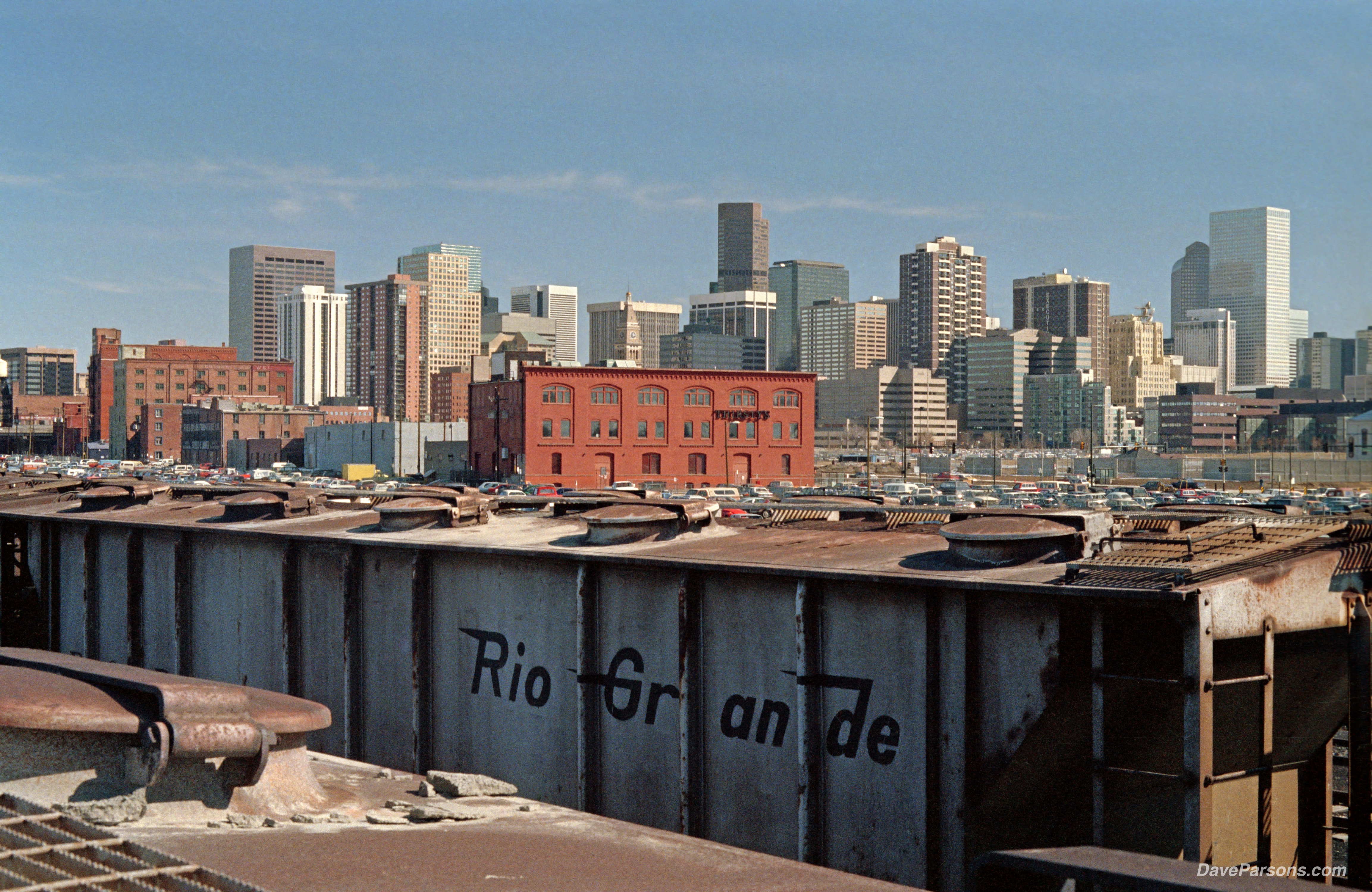
In 1989, while taking classes on the Auraria Campus, the adjacent freight rail yards with historic buildings and lines of railroad cars made for a great spot to explore. Parsons photo
Exploring Denver Tracks to Golden Trails - Written February, 2026
My Early Downtown Excursions
Rollerblading among Denvers's skyscrapers and photographing its open rail yards and historic architecture was an escape during years of school and work in downtown. It was relaxing after piles of homework and constant cramming for tests. It was also a way to break up the day and night commutes avoiding Denver's rush hour traffic. Also, I could indulge my childhood fascination with history and trains, wandering by the historic Union Station train depot and its surrounding variety of old, industrial rail structures. I climbed onto train cars, walked along miles of track lines and one day with my father, even scaled the ten story light tower in the middle of the yard near the 23rd Street viaduct long before the baseball stadium was built.
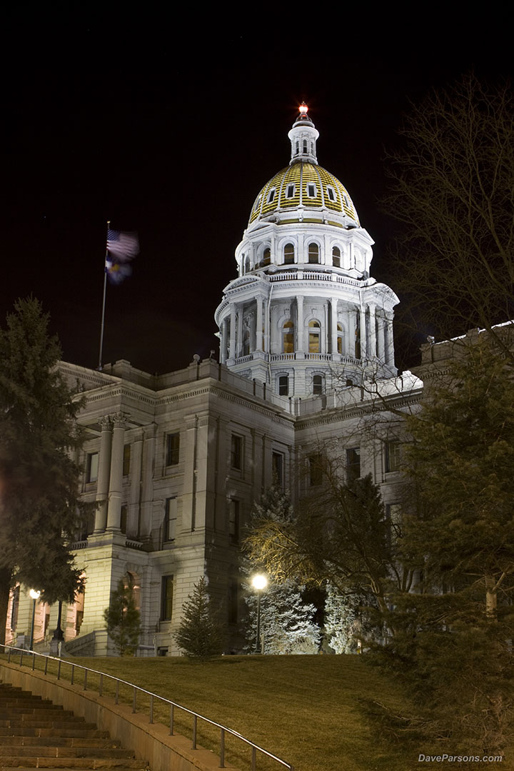
On new years eve, the U.S. flag flaps in a cold wind and the gold dome of the capitol glows warmly during a nighttime excursion into Denver's streets. Parsons photo
Other days when the weather was nice or after a summer class, I would jump on my late 1980s rollerblades and zip through Civic Center Park, along the South Platte River path, through the Auraria Campus and along the sidewalks of downtown. Many times loaded with a pack full of books and written notes and camera gear, I would jump over curbs, down short staircases and violently vibrate through rough pavement swaying this way and that while actively balancing, making the newly introduced sport more challenging.
Unfortunately, downtown law enforcement didn't have my same appreciation for the newly introduced and speedy blades. Likewise, while enjoying a sunny afternoon, an aggressive cop with a bad attitude made me stop while crossing on rollerblades through an intersection. With outstretched arms, the blue uniform with a holstered gun yelled at me to stop! -and I screeched to a halt while jamming my heel to the ground. He proceeded to give me an a stern "warning" for riding on the 16th Mall. I told him I wasn't riding on the mall, but just crossing the intersection. Not appreciating my protest as traffic zoomed by, he made me take off my blades while standing in the middle of the road. With my tennis shoes back in the car of the school parking lot, I again protested. "How am I suppose to cross the road?!" Now cradling my blades in my arms, I crossed the rest of the way in my socks! Safely distant from law enforcement, I jumped back in my blades and skated away. What a jackass!
A few years after graduating and a few lane changes in my career path, I was again downtown, this time working in the dot com and dot bomb internet fiasco. Once again during lunches, I would explore and wander past the historic Brown Palace, the State Capitol building, the U.S. Mint or hop onto the 16th Mall Ride to Union Station or Larimer Street.
However, straight away, I looked for an alternative method of transportation to avoid driving in the frustrating morning rush hour madness. I started taking a very early express bus along Kipling Avenue to Denver. Early mornings up at 5 am and on the bus by 6 am was draining! After walking to the bus stop in rain, snow or shine, waiting for it's arrival along the polluted and noisy speedway, a variety of morning smells would assault the rider upon boarding with overly perfumed passengers, pungent aftershave and overpowering, freshly laundered clothes. Then there was a quick search for a window seat, hopefully without compacted gum or some other unidentifiable substance on the seat. The packed bus would then lurch to abrupt stops and with abysmal acceleration, it would crawl along 6th Avenue as motorists behaving badly would weave like drunken morons in front of the bus with complete disregard. Needless to say, I continued looking for an alternative commute method.
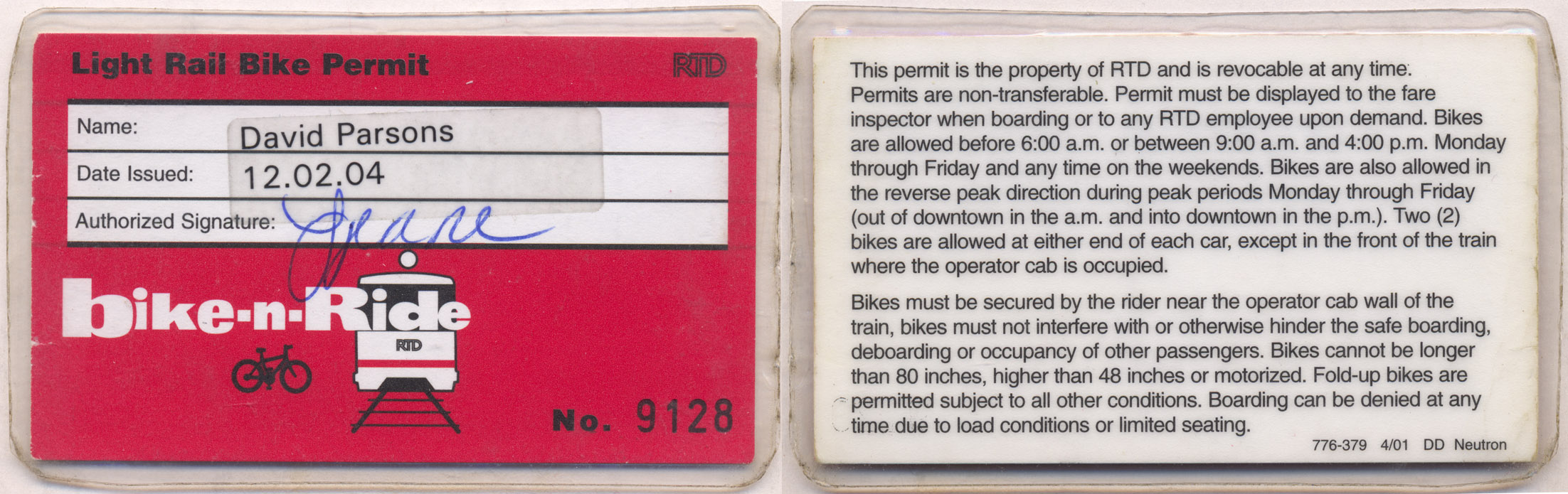
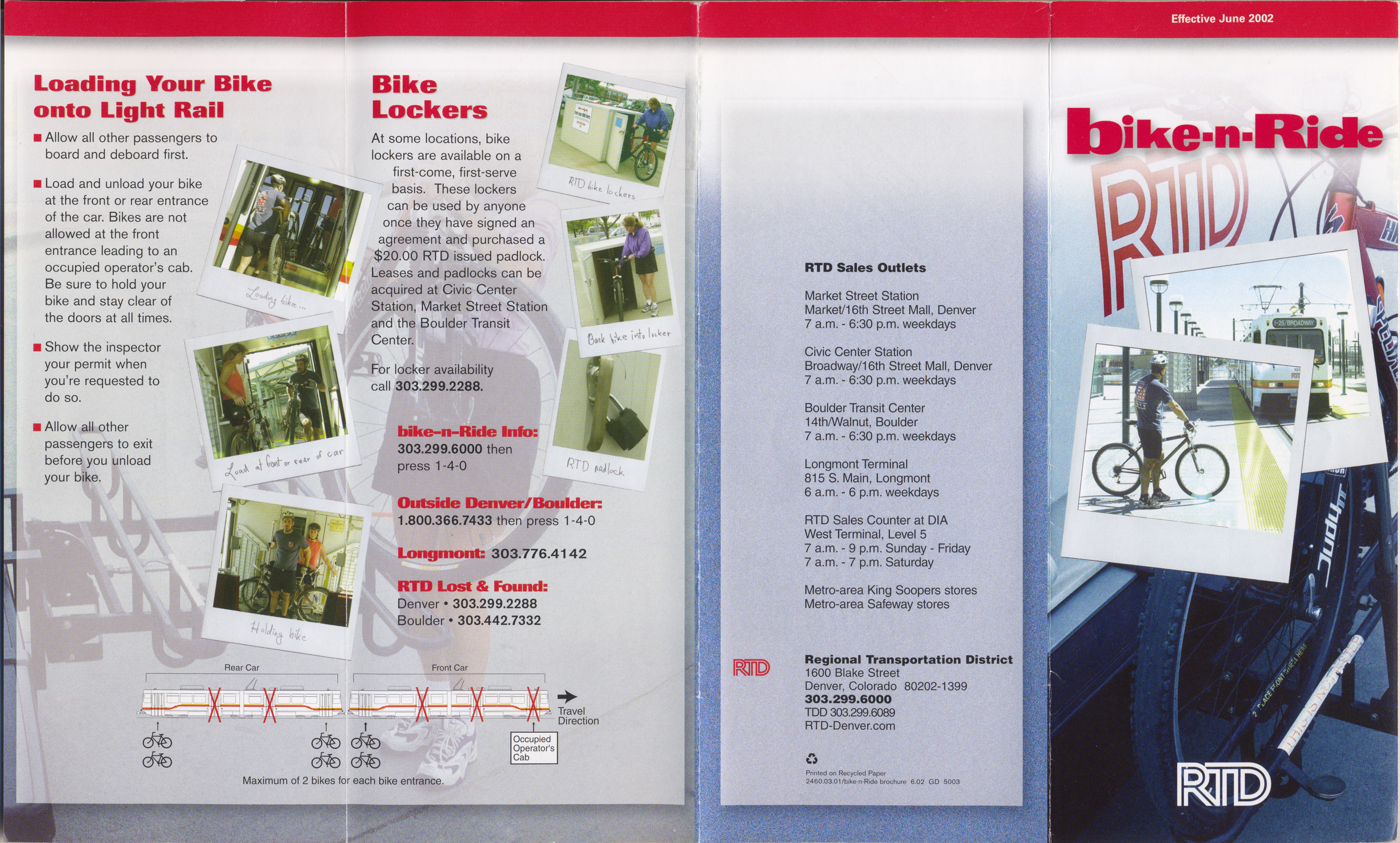
In 2004, a permit was required to ride the Light Rail with a bike when the program was initially introduced. Parsons collection
RTD put out a pamphlet in June of 2002 describing the introduction of Bike-n-Ride. The publications shows where bikes could be located on the train and bus.
Denver's light rail first started rolling on October 7, 1994 and the line was extended to Littleton in 2000 when I first transitioned to the train. It was a much improved ride experience being faster and smoother, but, required a longer initial commute to the station. Then a couple years later in 2002, RTD started allowing bicycles on the train. At the downtown Civic Center Station, I picked up my "learners permit" in 2004. My route then started with a six mile bike ride to Littleton station, where I would take a D-Line or Union Station train into downtown.
Rolling out of Littleton and through Englewood, I enjoyed watching the blur of south bound light rail cars and coal trains pass by as the car zipped past lanes of traffic stuck on Sante Fe boulevard. Looking to the right, downtown Denver skyscrapers would get closer as the urban landscape darted past and to the the left, the Front Range of the Rocky Mountains rose in the distance. Another bonus was, I was able stand up any time and move around if I didn't have my bike. For over a decade, I would bike or rollerblade to the light rail and ride from Littleton into Denver through a pair of internet jobs long after the dot bomb days of 2000 and the Great Recession of 2008.
Standing with my bike in a designated spot, the RTD D-Line light rail car zips along about 55 mph along Sante Fe Boulevard past a coal train to downtown Denver. Parsons video
I developed a liking for the speedy and at times, packed train and enjoyed the history my commute passed. At the I-25 at South Broadway Station, the 1911 built Gates Rubber Company factory with its huge rooftop water tower and broken windows would stand tall until it was demolished in 2014. Nearing downtown, the light rail cars would pass some of my favorite train yards lined with dozens of yellow train locomotives painted with Union Pacific or Southern Pacific that were sidelined on parallel rail spurs. It would roll past the historic 9th Street Park and Auraria campus where my four years of school quickly became outdated in the digital age of the internet. The train would continue over Cherry Creek, under the Convention Center and past the 16th street mall, Union Station, the Brown Palace and all sorts of Colorado history. The train ride became my imaginative connection to the past days of horse drawn, cable pulled and electric trollies that plied the dusty streets before the first "horseless carriages" in the 19th century. Likewise, in 2024 when downtown construction uncovered old, electric trolley lines buried below layers of asphalt and cement, I was able to see and feel a tangible connection to Denver's past and again explore my old stomping grounds as well as some new places.
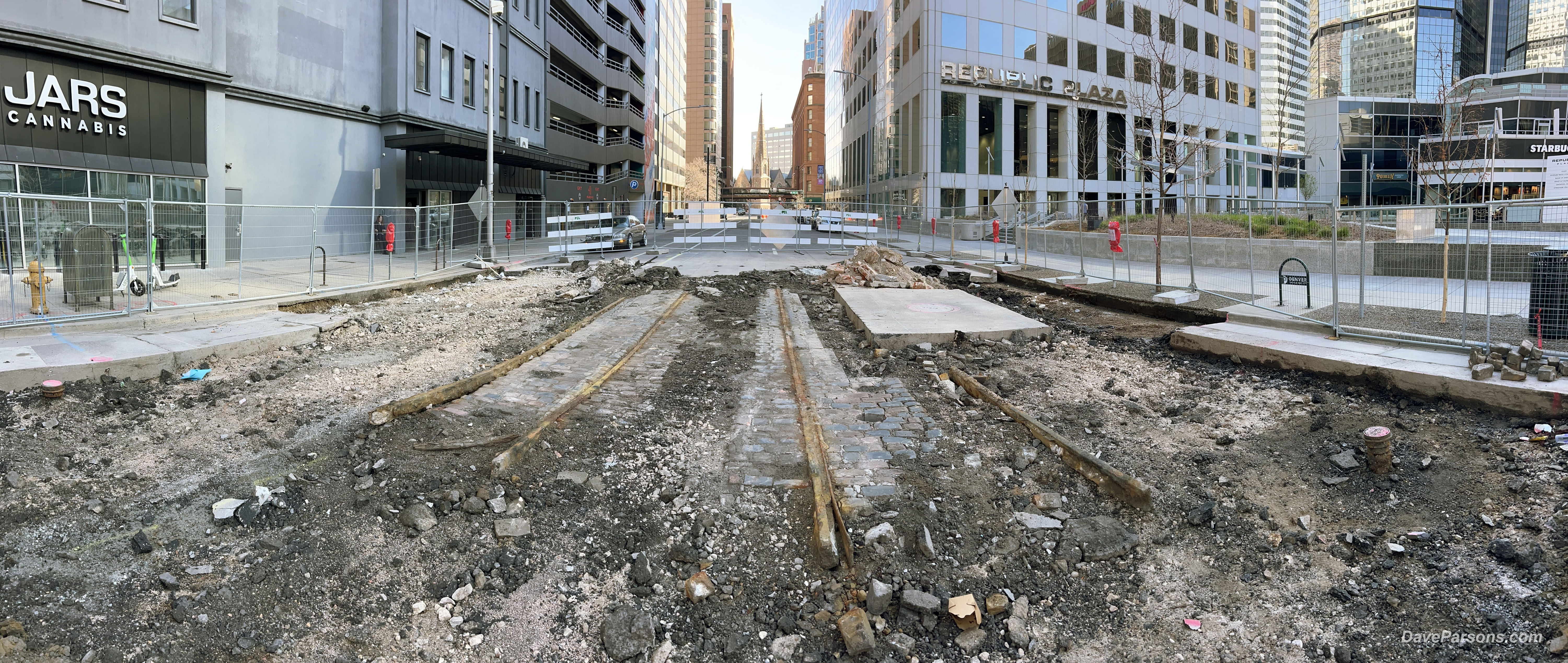
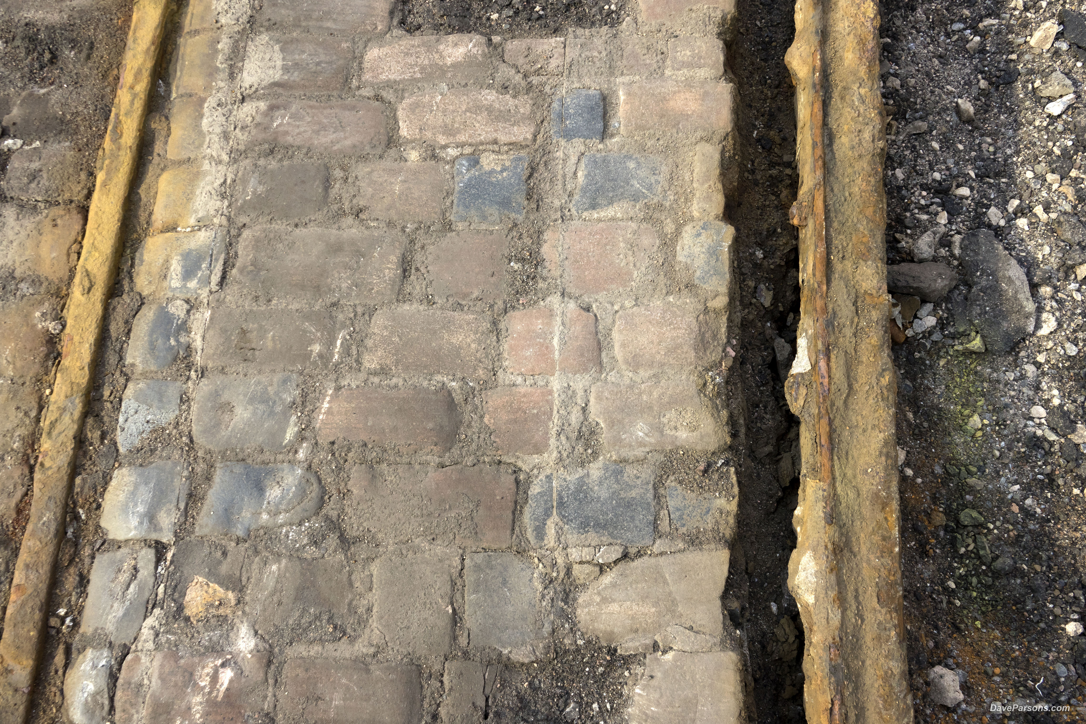
March 30, 2024 - Two pairs of tracks with basalt stone pavers in between at 16th and Tremont. The Brown Palace is in the distance on the right as is Trinity Methodist Church. Parsons photo
Photos of Tremont Street in 1971 and about 1900 - notice the center cable guides still remain in the middle of the tracks along with stone pavers in the earlier photo. Photos from the Denver Public Library Digital Collections.
Buried Downtown History
A Colorado history post on social media alerted me to a recent downtown discovery I had to check out. Again, trying to avoid any traffic, on a calm, weekend morning on March 30, 2024, I drove downtown to the YMCA building on Broadway and fed the roadside meter. Old lunch time haunts had disappeared and many businesses were replaced with pot shops. Feeling nostalgic, not for the pot shops but for the many days I had walked along the 16th Street Mall, it was now mostly deserted and in tough condition.
Trying to find a bit of warmth, a bundled homeless man slept curled up on his side in the middle of the closed road absorbing the steam rising out of a manhole cover vent. I felt a pang of sadness, but also felt grateful I was still able to explore. Too bad some things never change.
The 16th Street Mall was dug up and had barriers on all the cross streets. The $175.4 million project was started in April of 2022 to address the aging, original 1982 granite pedestrian pavers, deteriorating infrastructure and drainage problems of 16th street. Workers even replaced a water line dating from the 1880s.
Arriving at the Republic Plaza on Tremont and 16th, two pairs of trolley tracks were uncovered and held in place with stone pavers. According to the 16th Street Mall Project organizers, "While the streetcar line along 16th Street appears to have been removed during construction of the 16th Street Mall, which initially opened in 1982, the project team has discovered streetcar tracks at several intersections...," all of which have been covered by decades of road paving.
Cut marks and gouges damage the smoothed over basalt stone pavers in-situ between the rusted rails in the middle of Tremont Street. Parsons photo
At the intersection at Tremont, many cobblestones were scraped up and lying in the dirt and rubble. Rusty brown rails were bent and separating from the stone pavers. Slices and gouges from previous street construction had wounded many of the old stones. Cement slabs covered up part of the rails that disappeared under the pavement which ran northwards up Tremont towards the sunlit Trinity Methodist Church and the stately Brown Palace standing on the corner. A small pile of rescued stone pavers were piled near the sidewalk.
Glass covered skyscrapers loomed over the remains of the early electric trolley tracks. A loose chain link fence blocked most of the construction site preventing distracted, auto pilot pedestrians from falling in while sipping their Starbucks and looking at their phones. I found an easy entrance through the fence along 16th street which allowed me access to the newly exposed history. Walking through dirt and small cement chunks, I explored and photographed the remains of long buried stone and metallic carcasses.
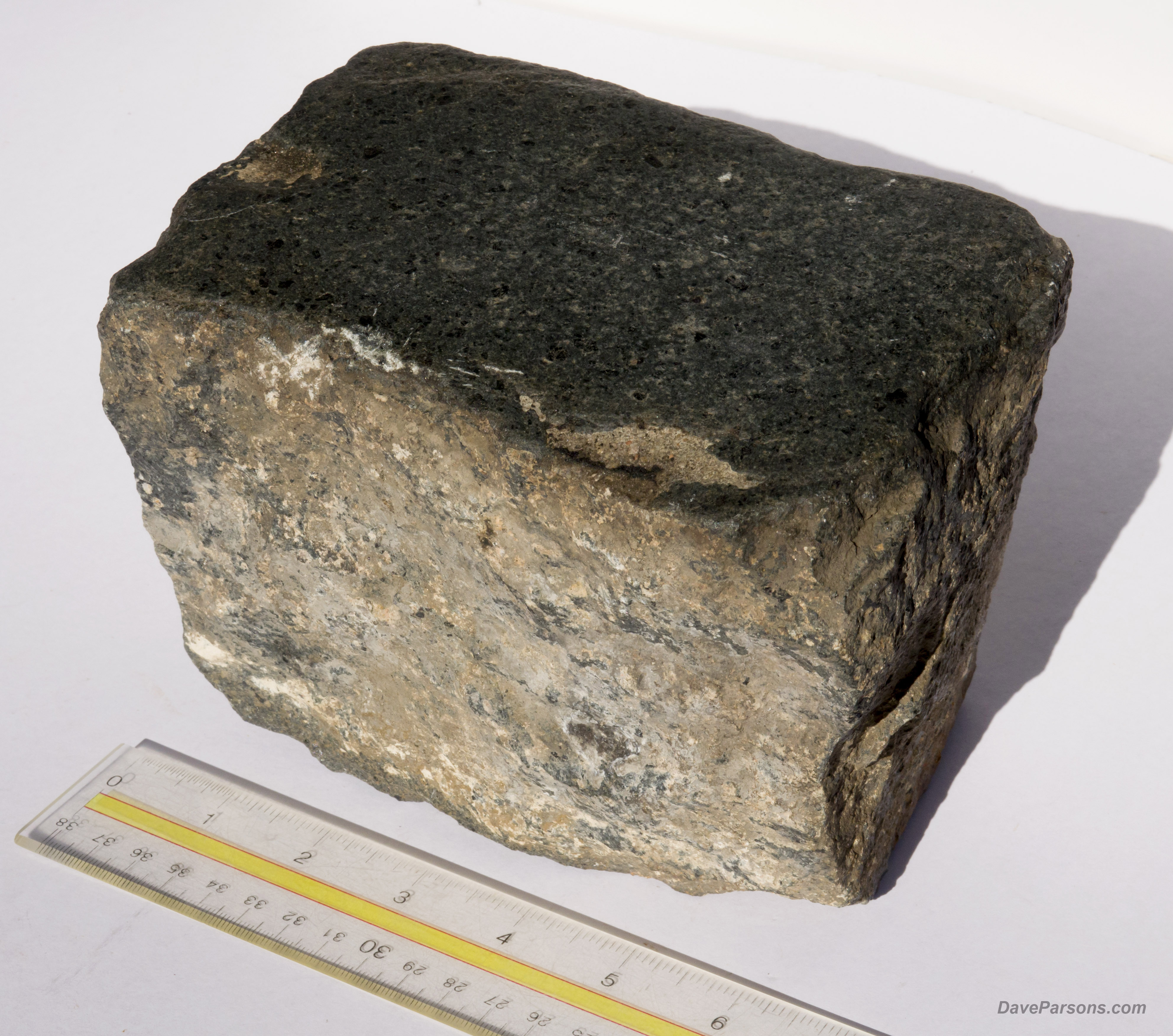
Polished smooth on top from decades of horse hooves, carts, pedestrians and vehicles, the heavy stone paver collected on March 30, 2024 from Tremont Street construction in Denver, weighs 12 pounds and is cut in a trapezoidal shape. It's dimensions are 4x7 inches on top and 5 inches tall. The brown basalt has magnetite inclusions and is indeed magnetic. Parsons photos
Picking up one of the stone pavers gouged out of its once happily nestled home, I hefted its solid weight and tried to look at the mineral composition through the encrusted grit and dirt. It would require more research, however, its weight made me me think it was granite. Rubbing a spot of dirt, the top surface was shiny, polished smooth by over a hundred years of horse shoes, poop, pedestrians, snow shovels, brooms, wagons, weather and trollies that had passed over. Likely to be tossed into a landfill as trash, I dusted it off and slid it into my camera bag leaving the remaining stone pavers to their fate. I feared that this little window into the past that most people would consider junk or find uninteresting would be torn up and discarded (Hopefully, some of the rails and pavers were rescued because today, its now paved over again).
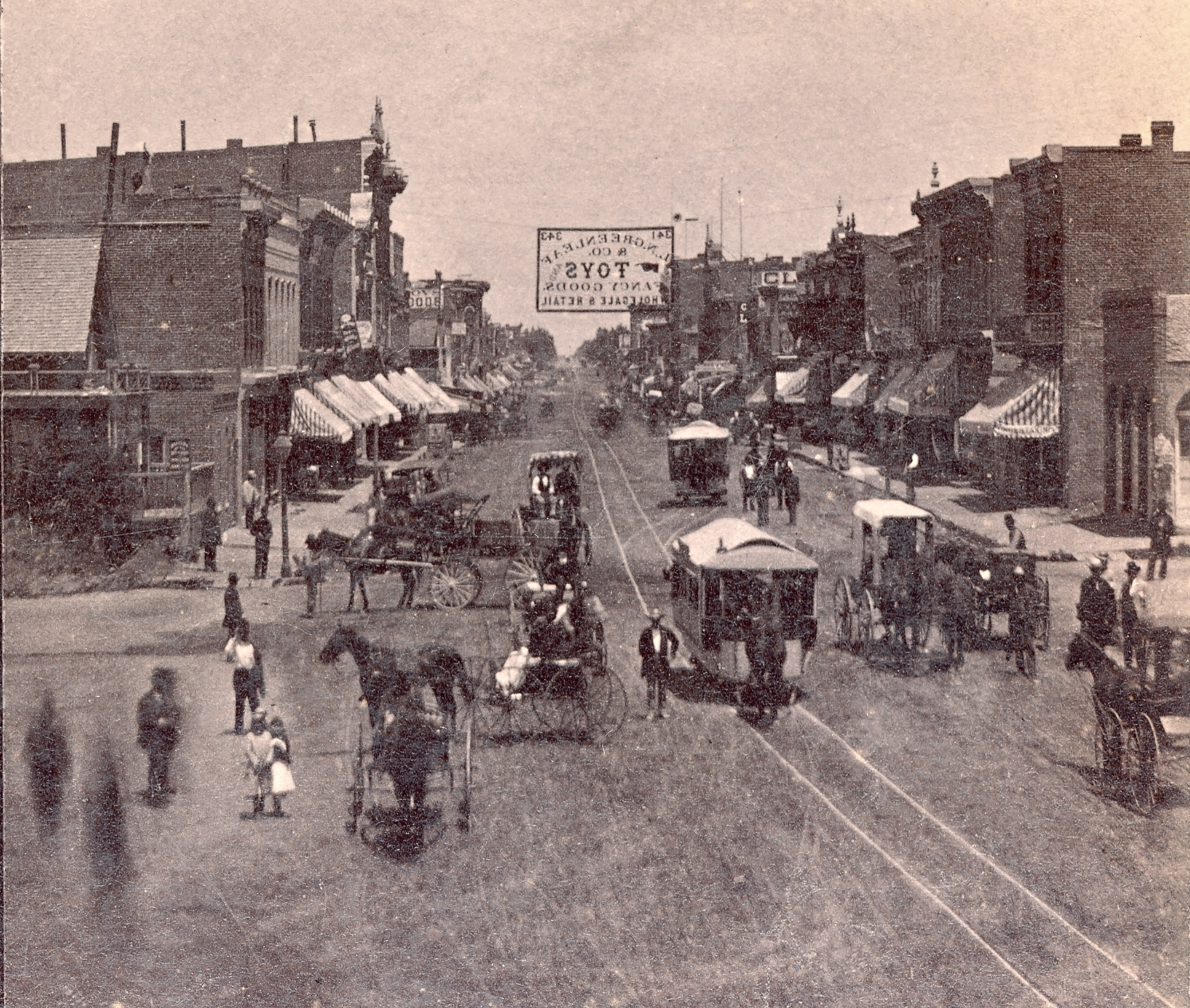
Wagons, carriages, pedestrians and two horse-pulled trolleys roll down a bustling Larimer Street past brick shops with striped awnings about 1878. The downtown Denver steroeoview photo by Charles Witfle was taken from the Cherry Creek bridge looking northeast. Parsons Collection
In 1871, when a dusty Denver was growing in leaps and bounds, the first tracks were laid down for horse drawn trollies by the Denver Horse Railroad Company. Later, in the 1880s, Denver Tramway dug trenches in between rails and introduced a conduit current system to power electric streetcars. After a few years, in 1888, due to expenses they switched to a network of cables which were threaded through the city like a giant maze. The centrally located Denver City Cable Railway Building at 15th Street and Colfax Avenue was a coal fired powerhouse that pulled the cable driven trollies through the network.
Another update occurred well over 120 years ago after the Denver Tramway Company converted it’s cable car route in 1889 to overhead electric trollies including on Tremont Street. Then in 1905, parts of the line were upgraded and cement was poured in and around the rails and into the cable trenches near the Brown Palace. Finally, the remaining trolley lines in downtown Denver were abandoned by 1951 and replaced by a new urban bus system. The last streetcar service rolled down the streets on July 3, 1950. Most of the tracks were simply paved over so cars and buses could take over the roadway.
Trolley tracks still remain in hidden spots throughout Denver and even another set of tracks were discovered in 2024 under nearby Colfax when Denver Water (PDF) was replacing a water line that required cutting through a pair of steel rails (denverwater.org).
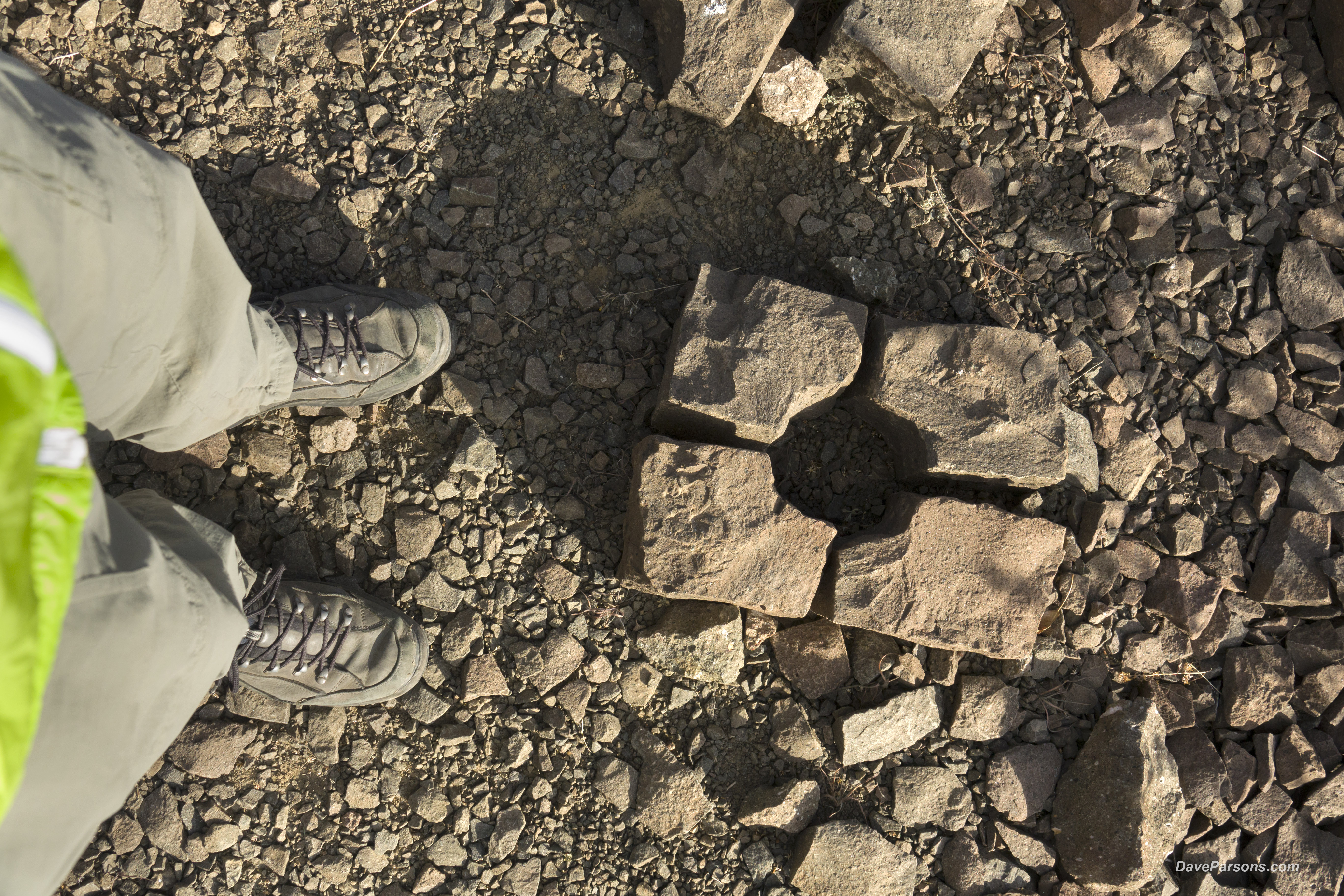
Basalt pavers with chips knocked off sit in piles at the Tramway Quarry. These stones would have been snugged up next to the top portion of the 'T' rails on the streets of Denver. See the diagram below. Parsons photo
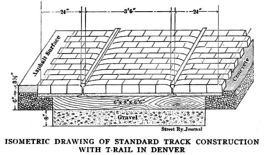
According to Denver's Street Railways, Volume I 1871-1900, the specifications laid out by the Tramway required that "on paved streets, track would ...consist of creosoted ties, to which would be spiked steel 'T' rail, 62 feet in length and weighing 72 pounds per yard. Asphalt would form the street surfacing and basalt block paving was to be placed on both sides of each rail. On unpaved streets, track standards were generally similar, except that 65 pound 'T' rail was to be used, with surfacing done with crushed basalt." Drawing from Denver City Tramway Company," Street Railway Journal Vol. XXII, No. 9 (August 29, 1903): pg. 333
After cleaning up
my rescued paver, I found an online reference to a basalt block paver (not granite!) in a 1903 drawing from Denver City Tramway Company. The heavy cut blocks held the trolley T-rails in place and some even had their corners cut off to secure the rail under the top of the T. I would later find out piles of corner cut pavers, likely cut in the early 1900s still remained on top of North Table Mountain today. Even crushed basalt was used in the rail bed surfacing. Nevertheless, the basalt reference opened up a much wider search leading to another historic spot, Golden, Colorado, and yes, another one of my favorite locations to explore! The stone had more historical secrets to reveal!
On to Golden!
North and South Table Mountains have long been great places to explore whether rock climbing, trail running, mountain biking and hiking. For over seven years while working in Golden, I would get out at lunch and hike South Table where the military from Camp George West once operated shooting ranges and ran maneuvers in the early 1900s on the south side of the mountain. 1934 photos show troops spread out with their rifles running over the prairie at the base of South Table as a primitive tank lumbered over yuccas and bi-planes flew overhead. Exploded fragments from mortar rounds, melted aluminum flare blobs, smashed lead bullets, shell casings and even live rounds would dot the dry yucca filled hillsides as would the occasional rattlesnake.
A 1901 .30-40 Krag shell casing found east of the Camp George West amphitheater in 1998 was used in a Krag–Jørgensen rifle, adopted by the U.S. military in the late 19th century. The "F" typically stands for "Frankford Arsenal," where it was manufactured in Pennsylvania. Parsons photo
Rattlesnakes were also a problem for the nearby 1934-5 Federal Emergency Relief Administration (FERA) built, 2,500 seat amphitheater for Camp George West which stood behind the 1940 built ammo bunker and the National Renewable Energy Laboratory's Solar Energy Research Facility. During nighttime movies for the local residents and troops, an occasional gun shot would ring out extinguishing a snake trying to snuggle-up to a warm leg. Or, the film projection would be halted when a "snake alert" caused a stir among flashlight toting viewers. Needless to say, the amphitheater was closed early on due to the infestation of rattlesnakes.
South Table Mountain also hosted an early 1900s incline railway or funicular on Castle Rock overlooking the town of Golden. There were even extensive basalt quarries on top of the mesa, the WPA Quarries (Works Progress Administration) accessed by Lava Lane road, later renamed Old Quarry Road, also adjacent to NREL.
But the basalt paving block came from North Table Mountain where it had it's own incline railway and quarry, the Tramway Quarry.
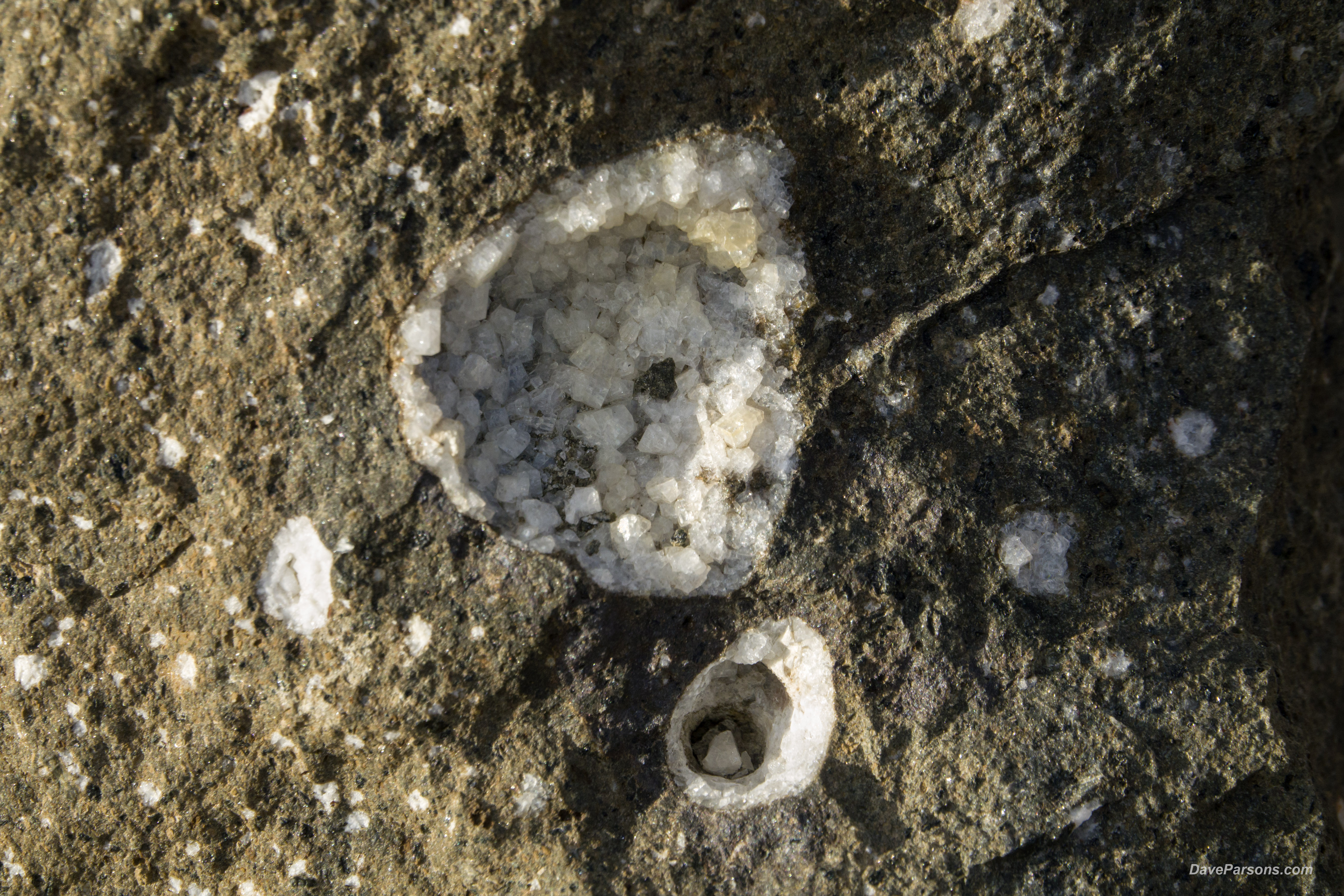
Voids, like this two inch wide bubble with an analcime mineral lining formed in a massive boulder in the ancient lava flow. Known as "vugs," they contain Zeolite minerals, geode like crystals in a hollow within the brown basalt. Arthur lakes and his Colorado School of Mines students collected samples from this quarry in 1874. Parsons photo
Originally, the quarry was opened in 1874 by the famous dinosaur bone hunter and Colorado School of Mines teacher, Arthur Lakes for mineral collecting, specifically, zeolite minerals. The area has long been known to mineral collectors where zeolites, the light colored mineral crystals lined natural holes in ancient volcanic lava flows called vugs. "Minerals included analcime, thompsonite, stilbite, and chabazite, some of which are on display at the Mines Museum of Earth Science." (Golden Rocks)
As mining and industry increased in Golden, the demand also increased for local mine specific, aggregate quarrying as well as clay mining along the convenient rail lines.
Similarly
"... in 1901, the mineral-collecting quarry became the site of one of the Whenestone/Blake quarries on North Table Mountain, operated by F.O. Blake, owner of Blake Asphalt and Paving Company. The massive basalt cliffs forming the rimrock were quarried for "monument" stones (tombstones), paving stones, and crushed rock. The biggest customer was the Denver City Tramway Company (later the Denver Tramway Co.), which had a substantial program of building roads and maintaining electrified interurban (streetcar) rail lines in the Denver-Golden area. The Denver Tramway Company (DTC) took over operations of the south (aka Tramway) quarry in 1905." (Golden Today)
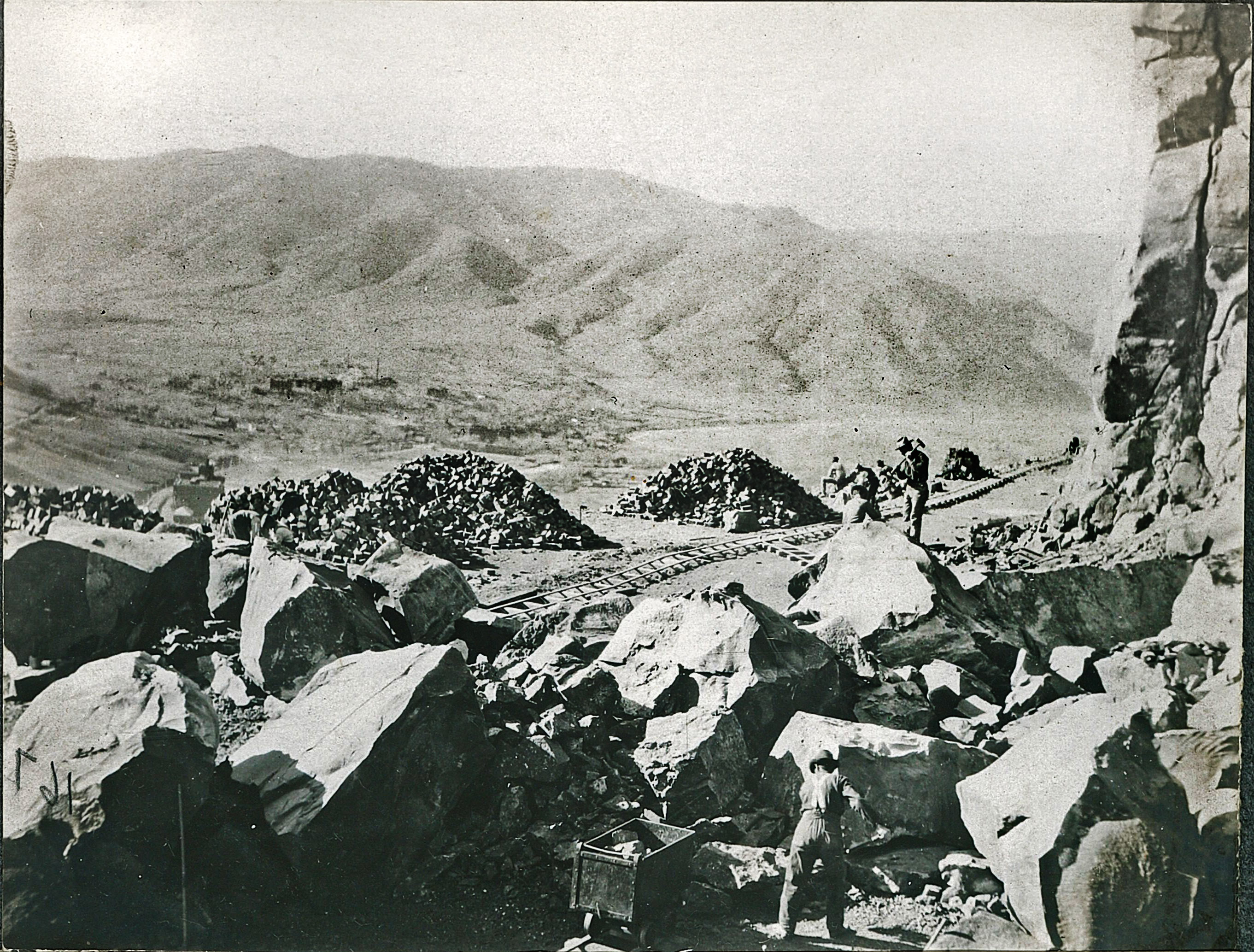
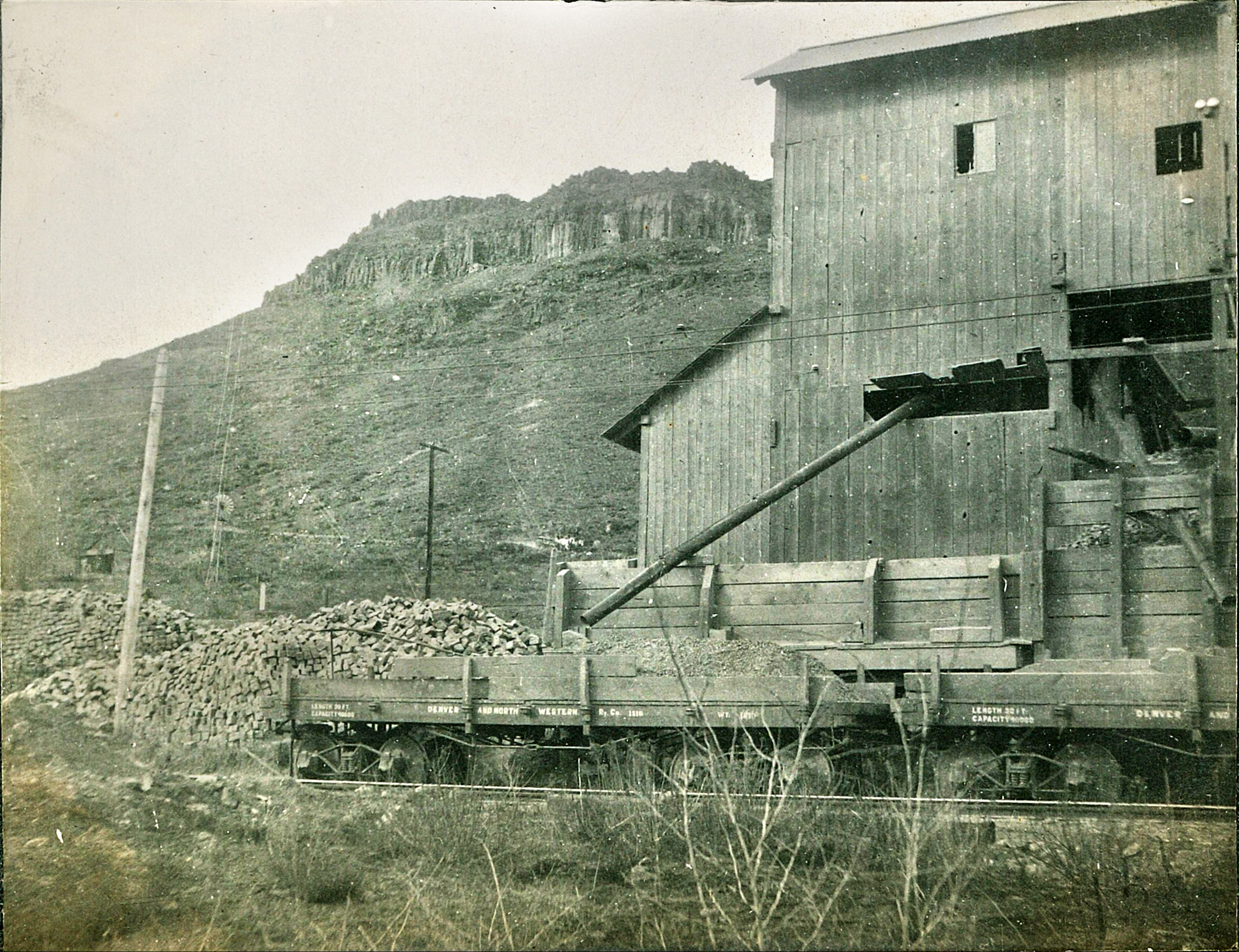
Looking west towards Lookout Mountain with the Colorado School of Mines and Clear Creek in the valley, workers break up rock in the basalt quarry about February, 1906. Large boulders, blown up with dynamite from the cliff side were broken up and shaped into rectangular pavers. Finished blocks were loaded on ore carts, rolled to the top of the tramway where another cart was filled and carefully rolled down the mountain. Notice the small rail spur lines to each boulder area.
Photo from Colorado Railroad Museum, Catalog Number 2025_83_7. Also found in Denver Street Railways Volume 3, page 80 where the photo was originally printed backwards.
Likewise, the Denver Tramway Company took advantage of acquiring their own crushed rock on North Table Mountain with its convenient and adjacent rail line operated by the Denver and Northwestern Railway.
However, they first had to get to the cliffs 700 feet above Clear Creek where heavy stone was quarried from the ancient lava flows that capped the mesa. The tricky part was moving the heavy basalt down to the valley floor. Initially, horse drawn wagons were used on a perilously steep dirt road. The problem was, good wagon brakes were notoriously rare, so teamsters would tie and lock up the rear wheels, literally dragging the wagons down the hill to the crusher. The reckless result was some near-miss disasters with runaway wagons.
From about 1907 to 1923, the Denver Tramway Company ran a pair of small, cable driven rail cars full of basalt from the Tramway Quarry, down the incline and across the small trestle over a dusty North Golden Road (West 44th Ave.) and Colorado & Southern Railway to the crushing building constructed in 1906. Photo from Colorado Railroad Museum, Denver Street Railways Volume Three
As a result, in 1907, the Denver Tramway Company constructed an inclined funicular using connected cables and ore carts. The system was counter-balanced, as one empty cart went up, the other descended full of stone. A single set of tracks was divided into two at the midway point on the mountain letting the two cars pass each other. On top of the incline at a loading dock, a motor driven drum was wound with thick cable and housed an attached braking system. The braking drum controlled the speed of a descending, loaded car and at the same time, pulled up the empty car.
The gravity system was much more efficient and safer than the horse and wagon route and moved more stone in a variety of sizes to the crusher building.
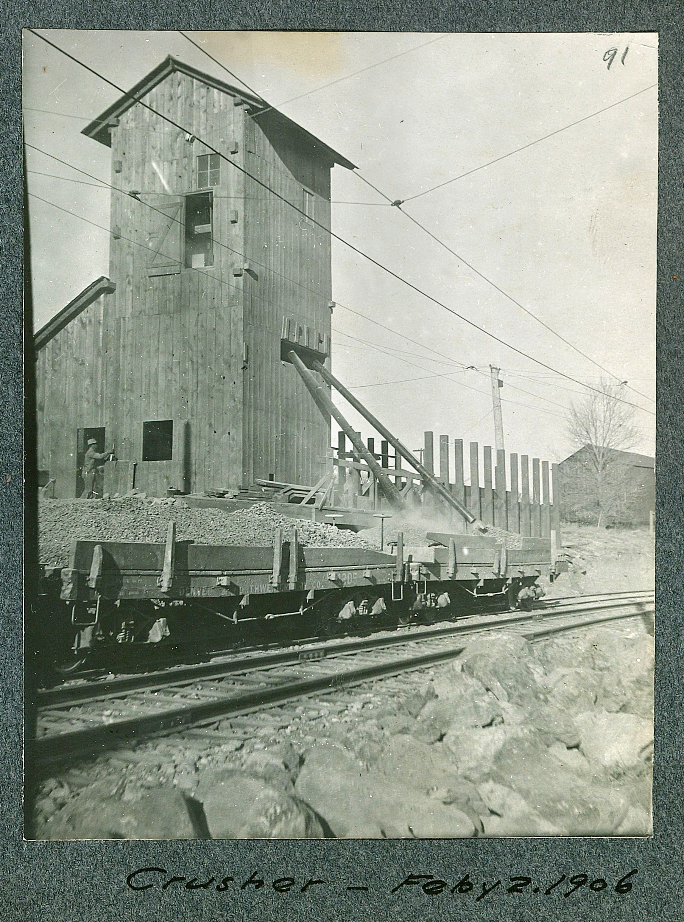
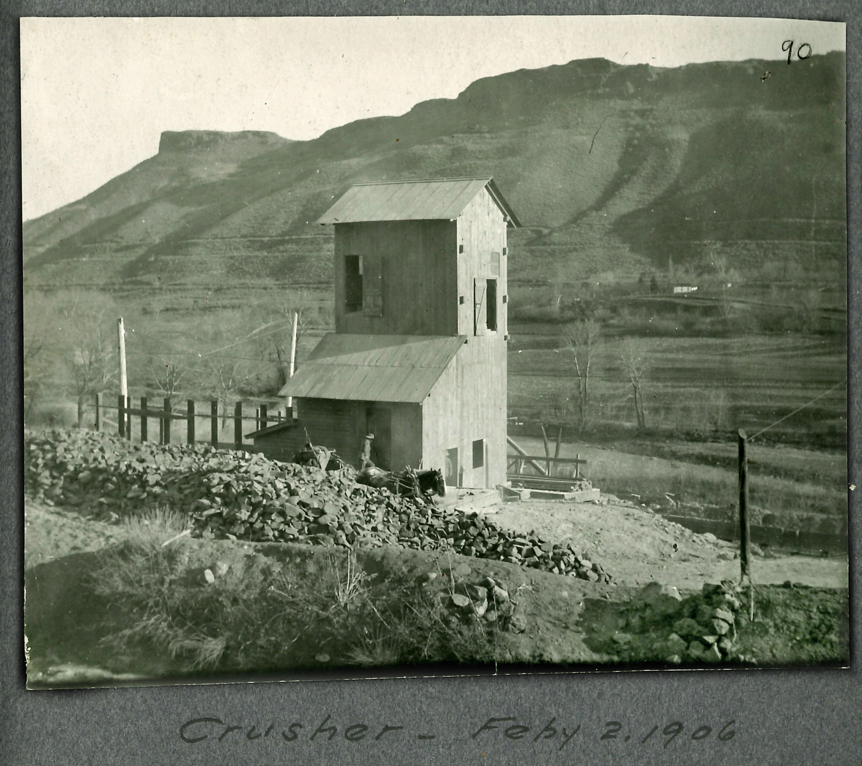
Built in 1906, the crusher stood on the north side of Clear Creek next to the parallel rail lines of the Colorado and Southern Railway and the Denver and Northwestern Railway. A trestle was also constructed for the incline to bring the ore carts safely over North Golden Road (West 44th Avenue) and the Colorado and Southern Railway. The tall, multi-story rock crushing plant with its rail siding for loading stone, also had a blacksmith shop with forge and sat about 100 yards away from the Weidman train station along the Denver and Northwestern Railway.
The newly built crusher on February 2, 1906 fills Denver and Northwester Railway cars with crushed stone and ballast. Photo from Colorado Railroad Museum, Catalog Number 2025_83_3
Solid rock that filled the ore carts and descended to the crusher below was also ground up for railway ballast, gravel sized stone delivered to Denver. Gravel ballast was used below a railroad bed to provide stability, support the weight of the tracks and trains, facilitate drainage, and minimize vibrations. It also helped keep the tracks in place and prevented them from shifting, ensuring safe train travel.
The ballast, also used to pave roads as well as stone pavers, were then loaded onto
Denver and Northwestern Railway 30 foot long, flat rail cars or gondolas that were pulled alongside the crusher on the siding. The stone in its various forms then rolled towards downtown Denver to be used throughout the city on roads and rail beds. In 1917, a roadbuilding project to pave West Colfax and South Golden Road, revived the idled quarry and it operations. The quarry and its small industrial zone along North Table Mountain were worked on-and-off until 1923 when the trestle, crusher and incline were abandoned and lay dormant for decades.
Today, much like the nearby Lookout Mountain Funicular Railway and the Castle Rock Funicular, the Tramway Quarry incline is just an angled scar climbing up the mountain where circling raptors, mule deer and rattlesnakes and rock climbers like to hang out. BNSF trains still roll along the north side of Clear Creek using the Colorado and Southern Railroad for the delivering Coors Brewery products into Denver.
"Ed Haley, the late Colorado railroad historian and co-author of Volume I of Denver's Street Railways, left us with his own recollection of the Tramway's quarry and rock-crushing facility:"
"I first visited the site in 1923
or 1924 after the operation had been abandoned. The crusher, bridge, mine railway and blacksmith shop were all still intact. My father drove an older friend and me out to the place, letting us out of the car beneath the wooden trestle over North Golden Road. We did not visit the crusher, but followed the incline up to the rim rock. About halfway to the top, the line parted and became two separate tracks for a short distance, so that up-bound and down-bound cars could pass each other. After looking at the mechanism at the top of the incline -- a large drum that once held the cable and braking assembly mounted at the end of the track above the loading dock and east of the quarry - we assumed that this had been a gravity system. The loaded car, under control of the braking assembly, pulled the empty car back up to the top of the incline.
With North Table Mountain rising in the background, basalt stone was rolled out of the Tramway Quarry into the crusher along the rail line. Gravel sized stone was delivered to Denver for ballast used as a layer underneath the railroad tracks. Gravel ballast was used below a railroad bed to provide stability, support the weight of the tracks and trains, facilitate drainage, and minimize vibrations. It also helped keep the tracks in place and prevented them from shifting, ensuring safe train travel. Photo from Colorado Railroad Museum, Catalog Number 2025_83_8.
There was much broken rock scattered around the base of the vertical rim rock. Apparently crews drilled directly into the base of the vertical wall of rock, placed charges, then blasted away sections of the basalt cliff that was cut into cobblestones and the remaining rubble was ground up into basalt aggregate for paving and concrete work. At the far west end of the quarry was a wooden building containing a forge and lots of blacksmithing tools along with many rock drills. This shop probably was used to keep the drilling bits sharp for rock drilling. The small mine railroad transported cobblestone and scrap rock to the loading dock at the head of the incline where the material was loaded and lowered to the crusher and the loading facilities for shipment to Denver.
As two men stand at the doors, a pair of harnessed horses with a cart load of supplies and piles of stone sit at the base of the crusher building. South Table Mountain stands in the background. Photo from Colorado Railroad Museum, Catalog Number 2025_83_3
"I visited the incline frequently
in the 1920's as the friend who first took me there had a sister who lived with her husband and children on a farm on top of North Table Mountain. We would ride the interurban to Weidman (the fare was 29 cents each way) and walk up the incline to the top, climb the escarpment, and then walk across the top of North Table Mountain to his sister's farm and we would spend the day there. By the 1930's the crusher, the rails and the bridge were gone, but the old blacksmith shop stood for many more years."
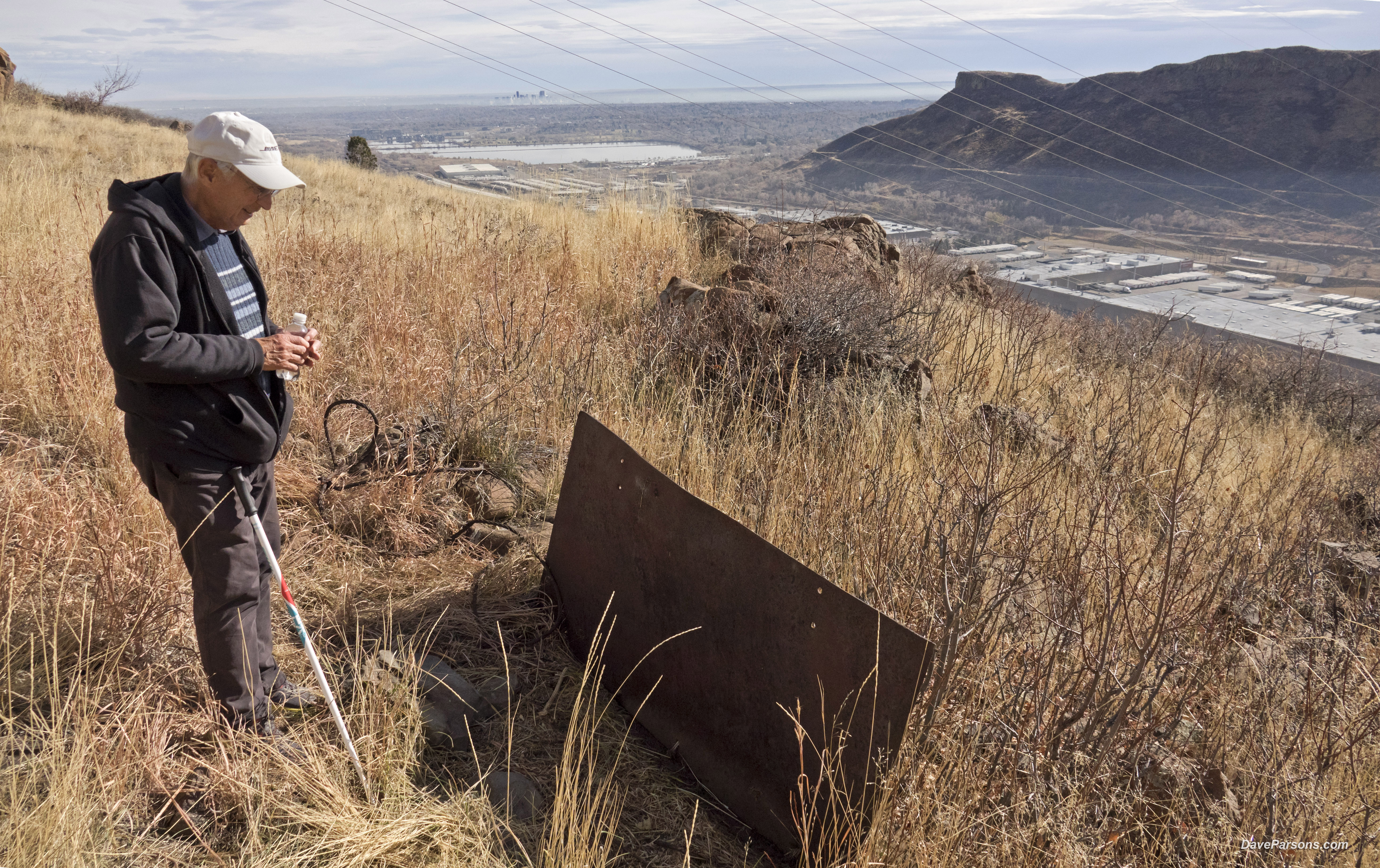
Inspired by the story of the 1920s visits, I made my own excursions to explore the south side of North Table Mountain and see where my basalt paver had come from and what remained of the Tramway Quarry and incline.
On a chilly, but sunny late November afternoon, I began my climb up the steep, dry grass slopes over a well worn dirt path in North Table Mountain Open Space Park. The route was littered with large and small basalt boulders that had rolled off the cliffs above. Lots of leafless, gray stemmed mountain mahogany shrubs clumped together in large swaths forming a thick, three foot tall ground cover.
It was likely too cold for any reptiles, but I kept a sharp eye out to avoid any rattlesnakes. After starting at the base of the mesa on a no name trail I quickly arrived at the popular North Rim trailhead where mountain bikers enjoyed cruising by. The path would climb higher near the basalt cliffs and steep hillsides which formed a wide open horseshoe and canyon-like area. Circling overhead with outstretched wings, a dark silhouette of a golden eagle soared on the heated updrafts from the sun warmed stone cliffs. Tall, dirty yellow and brittle grass lined the edge of the trail. Further along the trail, flapping quickly and then coasting, a prairie falcon hugged the cliff edges along the top of the mesa and flew through the open air space over Clear Creek, now far below. Looking eastwards, distant Downtown Denver skyscrapers stood in a haze of dirty smog. Closer to the quarry site, among the clumps of shrubs, a handful of mule deer wandered and nibbled along their many trails.
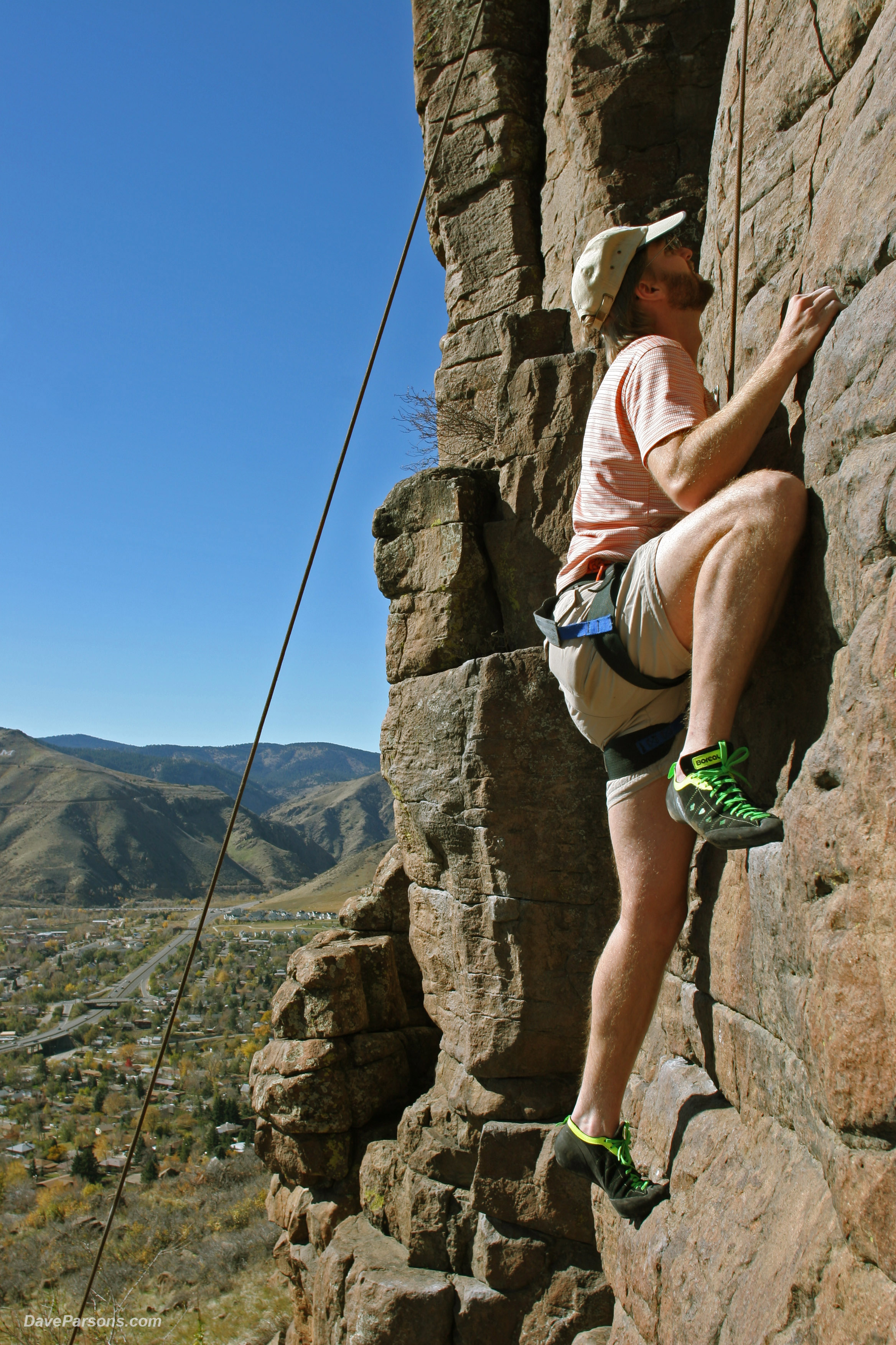
After about 45 minutes from the start of hiking, I was at the quarry as another trio of female mule deer wandered nearby. Like a typical mine, the site had it's pile of tailings where countless pavers and stones had been shaped and chipped. The quarry area was located next to an area where I had rock climbed with friends over twenty years ago. Bolts and carabiners still remained dangling on the basalt cliff face so harnessed climbers could top-rope, climb and repel safely.
Climbing an ancient lava flow! Looking west towards Lookout Mountain over two decades earlier, on October 30, 2004, with the help of friends, I climbed the cliffs on the basalt covered south facing side of North Table Mountain adjacent to where stone was once quarried over a hundred years earlier. Little did I realize the geology and human history I was climbing on! Claire O. photos - Parsons collection
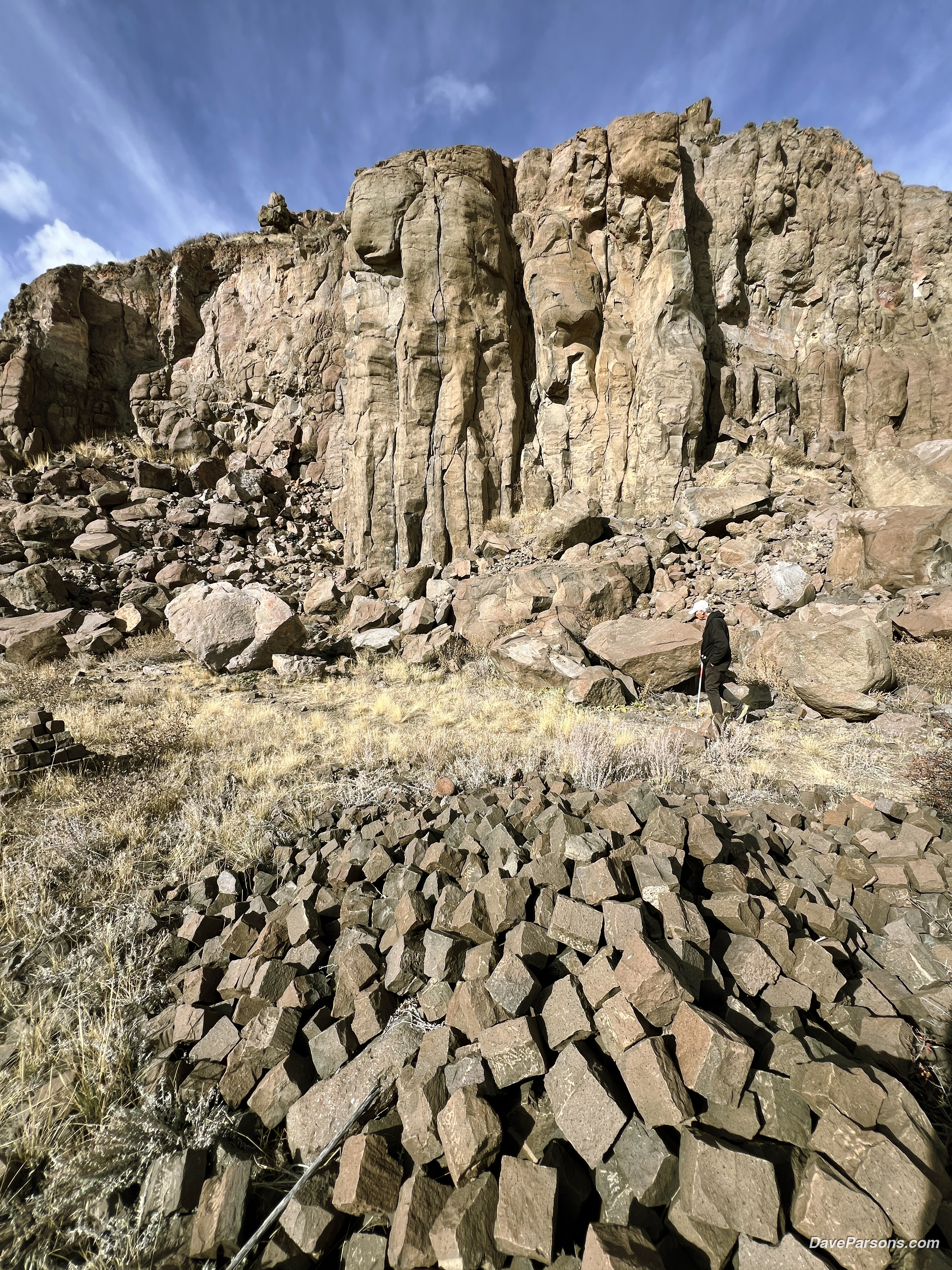
Walking along the edge of the quarry area just above the North Rim Trail, even today, piles of cut pavers hacked from boulders blown out with dynamite from the side of the cliffs remained in large piles, much like the 1906 quarry photos from the Colorado Railroad Museum archives. At the base of the basalt cliffs, large and jagged boulders still remained where they had been blown up and fell. Many of the stones had open lava bubbles or vugs lined with small white crystals inside like geodes. This was the original home of my basalt paver which was found under the streets of Denver! I picked up another paver. It was the same weight and size of the Denver paver. However, some of these had remains of drill holes from dynamiting and the corners were chipped out to be fitted along the top portion of a "T" railroad rail. The coloration was a bit more brown, perhaps from a different age lava flow.
Like they were just cut from the rock face,
a hiker walks among the piles of brown basalt which are left at the base of the cliffs that rock climbers frequent today in 2025. Parsons photo.
In a February 2, 1906 photo, quarrymen with shovels and pry-bars fill a wheelbarrow with stone. Photo from Colorado Railroad Museum, Catalog Number 2025_83_5.
Looking back towards Denver, I hiked eastwards where the incline platform would have been located. Walking where the deer had been browsing along their grassy trails, it quickly became apparent it was the overgrown rail bed the small quarry line ran on. Ore carts filled with stone pavers and boulders would have rolled from the quarry to the incline along the base of the rock climbing cliffs.
The sun was going down quickly now and I descended from the road back to the main trail and looked for the rail bed of the steep incline railway in the tall grass. Cut into the hillside and heading towards Clear Creek, there was another overgrown road in the shade which was likely the early wagon road to the base of the mesa. Standing on the wagon road, I again looked east over a gully and towards what I thought looked like the rail bed for the incline. Unfortunately, the winter sun was setting too quickly to fully explore the area. I would have to make another visit and next time I would bring along my father who was always up to exploring a new area with rail history.
Looking eastwards into a temperature inverted cloud of pollution, unused and cut brown basalt blocks still remain in a pile on the south side of North Table Mountain at the base of the Tramway Quarry. The paving stones were once destined to be used in downtown Denver before the quarry shuttered in 1917. (Parsons photo)
In 1906, also looking eastwards, multiple and massive piles of cut stone are ready to be rolled down the mountain. Photo from Colorado Railroad Museum, Catalog Number 2025_83_6.
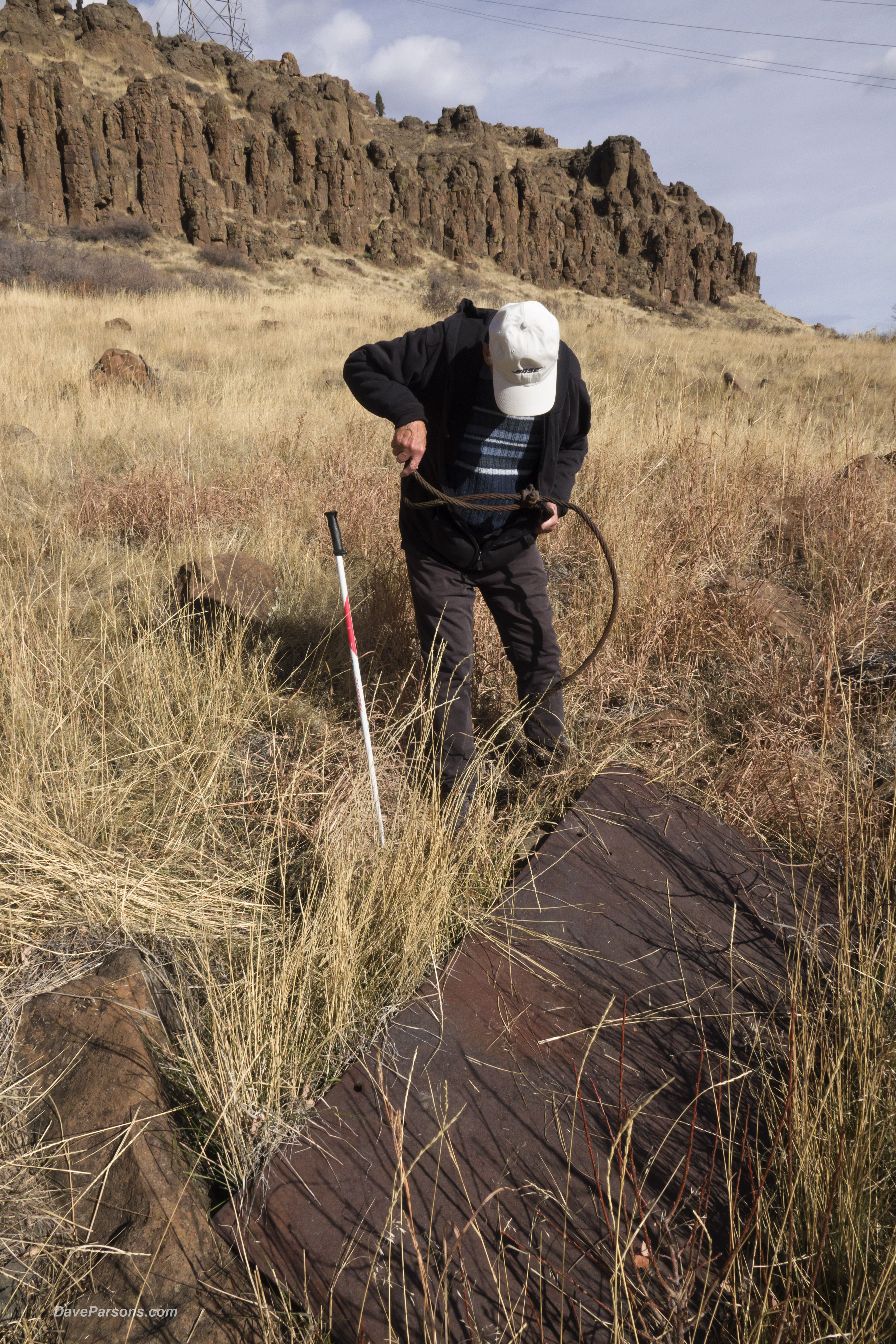
A few days later after Thanksgiving, my father and I started hiking in the late morning as we ascended the canyon area and gained the North Rim Trail. There were many more mountain bikers this time. Numerous pairs pedaled rapidly navigating past us along the rocky trail. The deer were no where to be seen and the raptors from the previous hike were also gone. A temperature inversion wrapped downtown Denver in a heavy smog blanket which reached towards Golden. About half way up the mountain, we emerged from the cloud which was now visible on South Table Mountain. The sun was out and it was warming up rapidly. We made our way towards the quarry and I quickly picked up the rail bed for the Tramway Quarry. This time we found direct, rusty evidence of the incline.
Walking the railroad grade of the Tramway Quarry with ancient lava flows along the cliff tops of North Table Mountains. Downtown Denver and South Table Mountain stand in the distance.
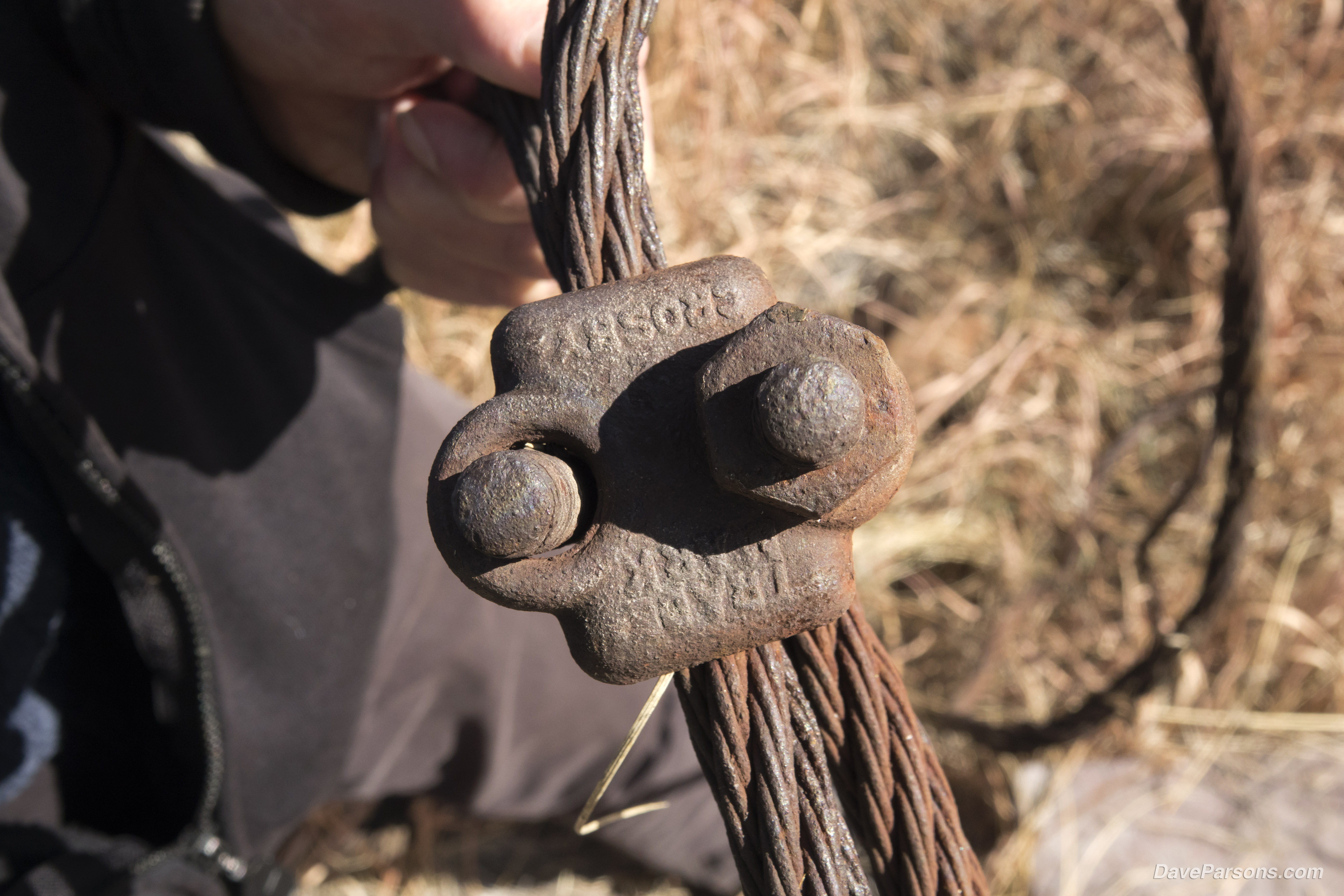
Walking the rail bed while avoiding the thick scrub, we explored the tall grass beneath the area where the loading dock would have stood. A large and thick, steel plate remained lodged in the soil with likely, part of the gravity system cable. Using my dad's walking pole we levered up the panel to see the underside - thankfully there were no rattlesnakes! There were two pairs of holes on either side of a bend in the middle of the rusty sheet the size of a large bath towel. Perhaps it was part of a sluicing mechanism used to funnel stone into the ore cars. Sitting underneath the sheet was part of a rusted cable, about a inch thick which was wound with narrow strands of steel making up a larger single unit. A rusty clamp was still attached to the cable and had raised "TRADE MARK CROSBY" lettering across the flat spots that once held two hexagonal bolts (one was still holding on). Taking a few photos, I documented the early 1900s artifacts and left them there to rust away.
Using the pole as a lever, we lifted the heavy steel sheet up for a look at the underside. Thankfully, no rattlesnakes! The thick steel plate was bent in the middle perhaps indicating it had been used to sluice stone into ore carts.
Just down from the rail, near a steel plate, a heavy duty cable and clamp remain in adjacent to the rail grade. The bolted clamp has "TRADE MARK" and "CROSBY" in raised lettering on the face. The cable would be used to lower an ore cart full of cut pavers from the top of the tracks as an empty car would be raised from the bottom. An area in the middle of the mountain would have two sets of tracks so the carts could pass each other.
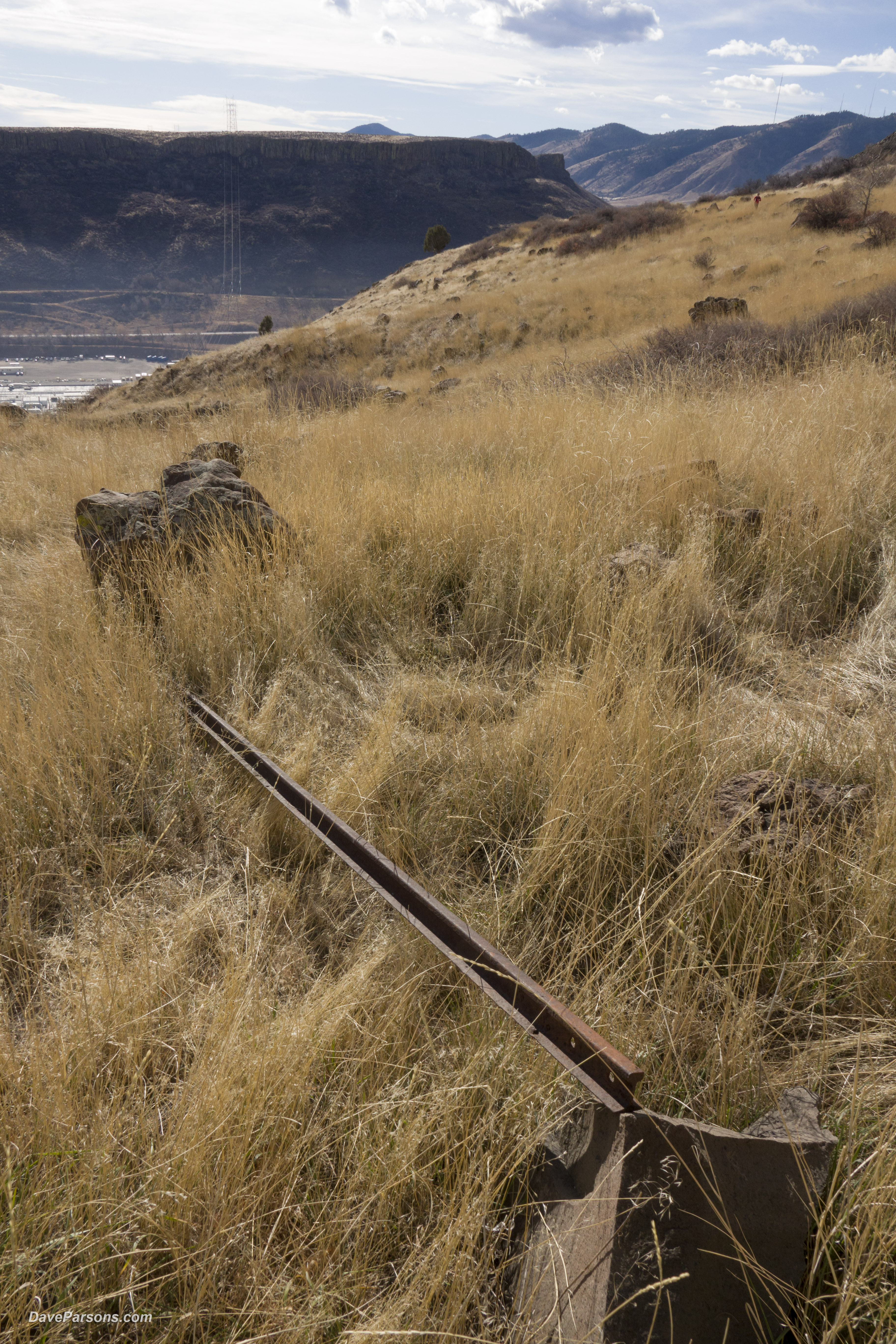
We decided to stay higher on the mountain because the rail bed descended into steep slopes filled with thick brush and eventually led into private property. Likewise, we proceeded up the hillside, following the grade back towards the trail. Just a few dozen yards away from the cable and steel sheet and burrowed in the tall grass, we found a long, heavy, mining gauge railroad rail about 12 feet long. It would have likely been used along the incline. I picked up one end and balanced the rail on a rock to photograph. Again we replaced the rail where we found it. There were a few more random rusty parts near near the rail I also photographed and left to decompose.
Rusting away in the tall grass, a loose mining rail from the Quarry Tramway sits on the grade heading downhill towards Clear Creek.
Returning to the trail we headed over to the quarry and explored the paver piles as rock climbers now filled the walls among the various routes along the cliffs. Bike traffic was beginning to pick up as we wandered among the quarry rock piles. Denver was still engulfed it its hazy blanket as we turned eastwards to descend the mountain, happy in our historic discoveries.
Yet, I still had more questions about the different colorations of the basalt. It would turn out there were four different lava flows that had erupted from another local landmark and spread over the entire Golden area.
A Volcanic History
The volcanic stone, was not only was ideal for paving stones, ballast and mineral rich, it also contained a rich geologic history reaching back to the age of dinosaurs.
On North and South Table Mountains, at least four different lava flows sit on top of tilted sedimentary floodplain depots (Denver Formation) which contain numerous fossils including palm tree fossils. In 1874, one of Arthur Lakes students even found a T-Rex tooth on the lower southwest base of South Table Mountain. A few years later in the 1880's Arthur found a fossilized sandstone palm frond in the area. I was even able to find a sandstone boulder with palm frond impressions on South Table Mountain above NREL. (I donated the fossil along with photos of where it was discovered to the NREL visitors center.)
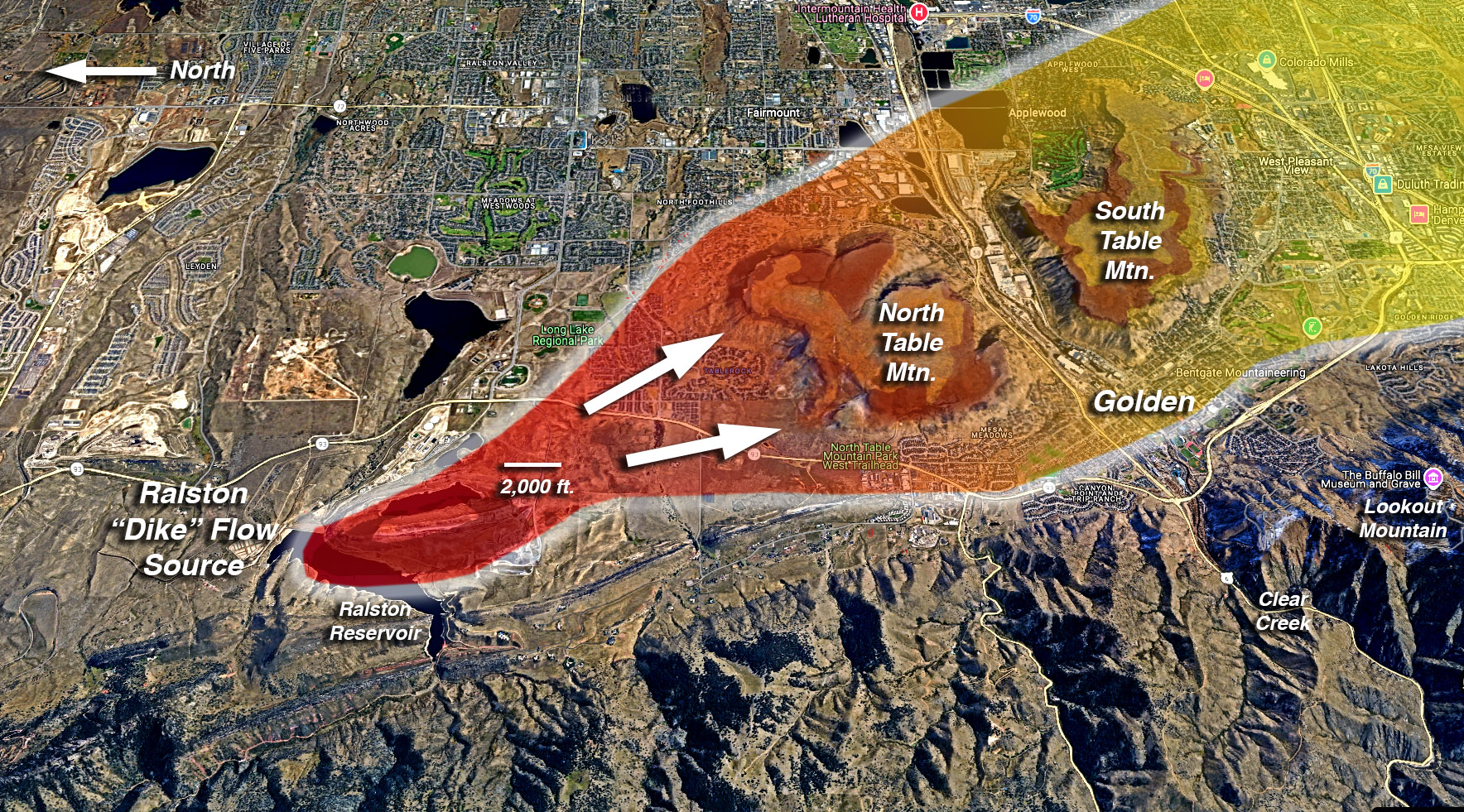
The latest lava flows occurred about 66.5 million years ago and according to the experts, flowed from the Ralston Reservoir area just a couple of miles to the northwest.
"As suspected by geologists since the late 1800s, a volcanic vent complex at Ralston Dike, about two miles north of North Table Mountain, is the likely source of the Table Mountain volcanic flows. The outer part of Ralston Dike is 65.4 ± 0.2 Ma old, an age compatible with Flows 2 through 4 on North Table Mountain. Also, the basalts at Ralston Dike are the same composition as the TableMountain basalts. The flows apparently came up along the subsurface trace of the Golden Fault during the Laramide Orogeny. Ralston Dike is more correctly called an exhumed volcanic plug. That is, it did not form a large volcano or an underground dike per se. The small cone where the vent came to surface was stripped away by erosion long ago, leaving only the eroded plug as the volcanic remnant. The lava flows from Ralston Dike flowed across the ancient landscape in a southerly direction toward present-day North and South Table Mountains, filling shallow channels of pre-existing rivers and streams. (Golden Rocks page 25)
Four lava flows passed over Golden running southwards from the Ralston Reservoir area along the Golden fault. The 3rd flow ended on the south side of Green Mountain 65 million years ago.
All the dinosaur aged lava flows contain a potassium-rich basalt called "shoshonite" and make up the cliffs on both North and South Table Mountains. However, the oldest, first two flows are only present on North Table Mountain. The 3rd and 4th flows cap both mountains and form their cliffs as well as make up the prominent landmark of Castle Rock on South Table Mountain. The basalt was also heavily quarried on top of South Table. The largest flow, extending over ten miles, was flow number three, even reaching the base of Green Mountain. The age of the four lava flows in millions of years, plus or minus are as follows:
Flow 4 - 65.9 Ma ±0.3 Ma
Flow 3 - 65.5 Ma ±0.3 Ma
Flow 2 - 65.8 Ma ±0.2 Ma
Flow 1 - 66.5 Ma ±0.3 Ma
Looking from the Triceratops Trail in Golden at North and South Table Mountains with their exposed lava flows and the fossil bearing layers of the Laramie and Denver formations. Parsons photo
The shoshonite basalt on North Table Mountain primarily consists of potassium-rich minerals including feldspar and biotite. It is characterized by its fine grained, porphyritic texture in which large crystals, known as phenocrysts, are embedded within a finer-grained matrix. This is a result from lava undergoing two stages of cooling, the first slowly, allowing large crystals to form, followed by rapid cooling that produced smaller crystals. As the lava cooled, it could also acquire strong magnetic properties due to the iron oxide minerals like magnetite, the most magnetic of all naturally occurring minerals. Similarly, both the pavers from Denver and Golden contained magnetite inclusions and interestingly, small magnets stick to the boulders. Finally, the basalt sits on top of the Denver Formation dating from the Late Cretaceous to the early Paleocene and consists mainly of claystone, siltstone, and sandstone.
The fine grained basalt, highly dense, water resistant and extremely durable was a sought after material that could withstand heavy loads and traffic. Furthermore, a naturally formed rock, basalt does not contain harmful chemicals like man made materials that could leach into the environment. In addition to the streets and railways of Denver, the quarried basalt from both North and South Table Mountains was used all around the Golden Area, in Camp George West structures, WPA projects, roads around Red Rocks and Morrison, and even filling Cherry Creek Dam with rip rap.
The basalt paver led me on a 65 million year old trail. Its an amazingly long and varied history for just one stone found under the streets of Denver. Nonetheless, it gave me the opportunity to explore some of Golden's hidden mining history and its amazingly diverse geology and paleontology. Driving around Golden and Denver, or looking up at Castle Rock, I will always question not only what is on the surface, but investigate what's underneath and why its there.
But, there's an unfinished trail of the basalt paver - an incline railway was also located at a second quarry on North Table Mountain. On the west side of the mountain, the Blake Quarry was opened in 1899 by F. O. Blake who leased the entire top of North Table to mine the basalt. Later in 1909 the Wescott-Doane Company took over operations and installed an all-electric crushing facility and a gravity-driven tramway down the mountainside, this time to a branch of the Colorado and Southern Railroad.
Looks like my dad and I have some more exploring to do!
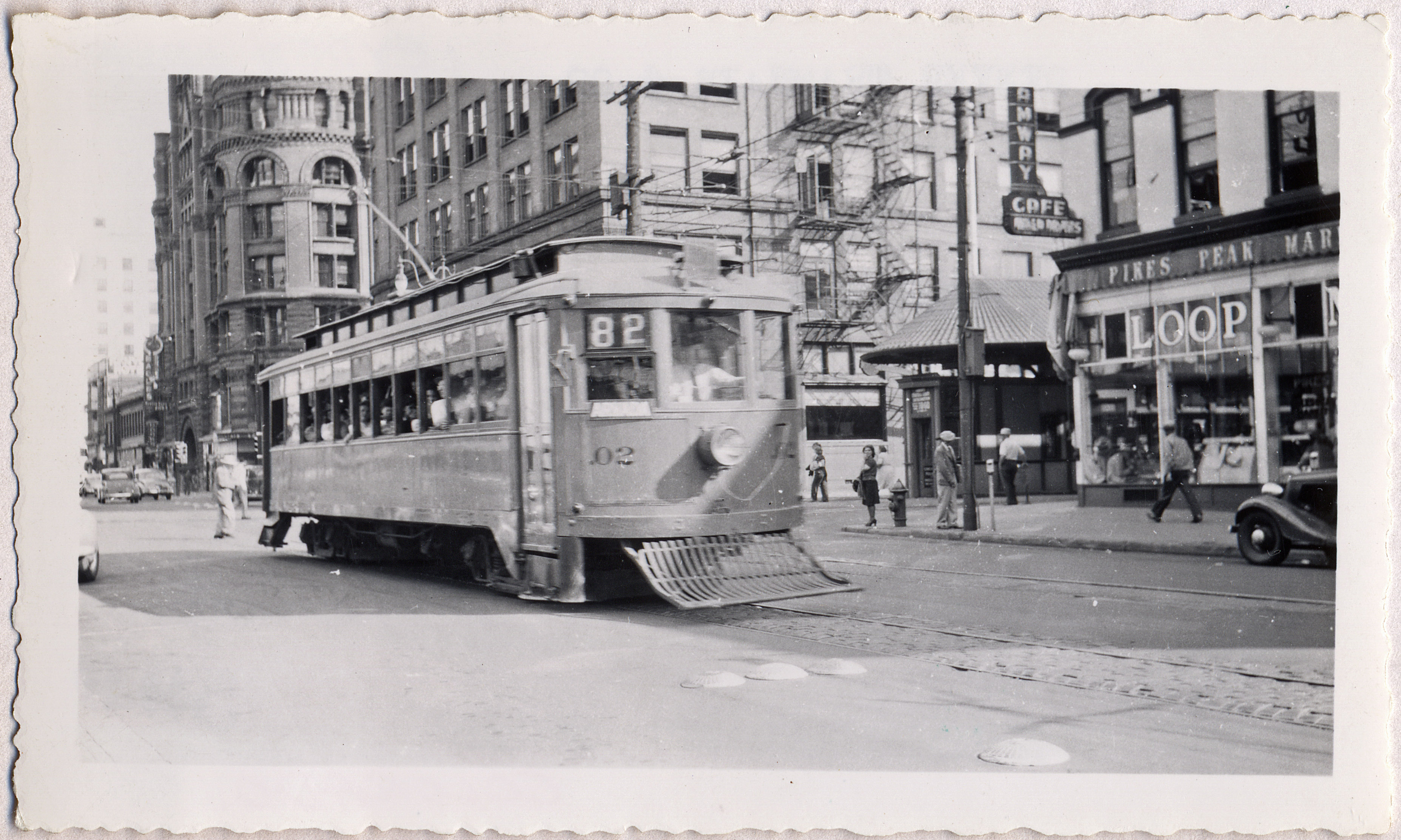
More basalt cobblestone pavers line the tracks on 15th street like the ones recently uncovered on Tremont. I wonder if they are still there? The photo looks southeast from 15th and Arapahoe with the Mining Exchange Building in the background and Loop Market station in front of the Pikes Peak Market. Parsons Collection.
"An interurban car has just left the Central Loop and is traveling northwest on 15th Street. Tramway passengers could stop by the Loop Market for groceries before heading on home." (P. 165 Denver Street Railways Vol. 3) "In a Tramway memo, cars No. .02 (originally built 1911-2 and rebuilt April 28, 1924) and .03 were placed in service on March 3, 1924 on Route 82 Arvada - Leyden line which terminated at Lakeside." (P. 163)