Looking northeast towards the lower part of the island which once housed fishing stages and small living quarters. A small tool shed with a collapsed roof remains from 2010 and 2011 archaeological excavations.
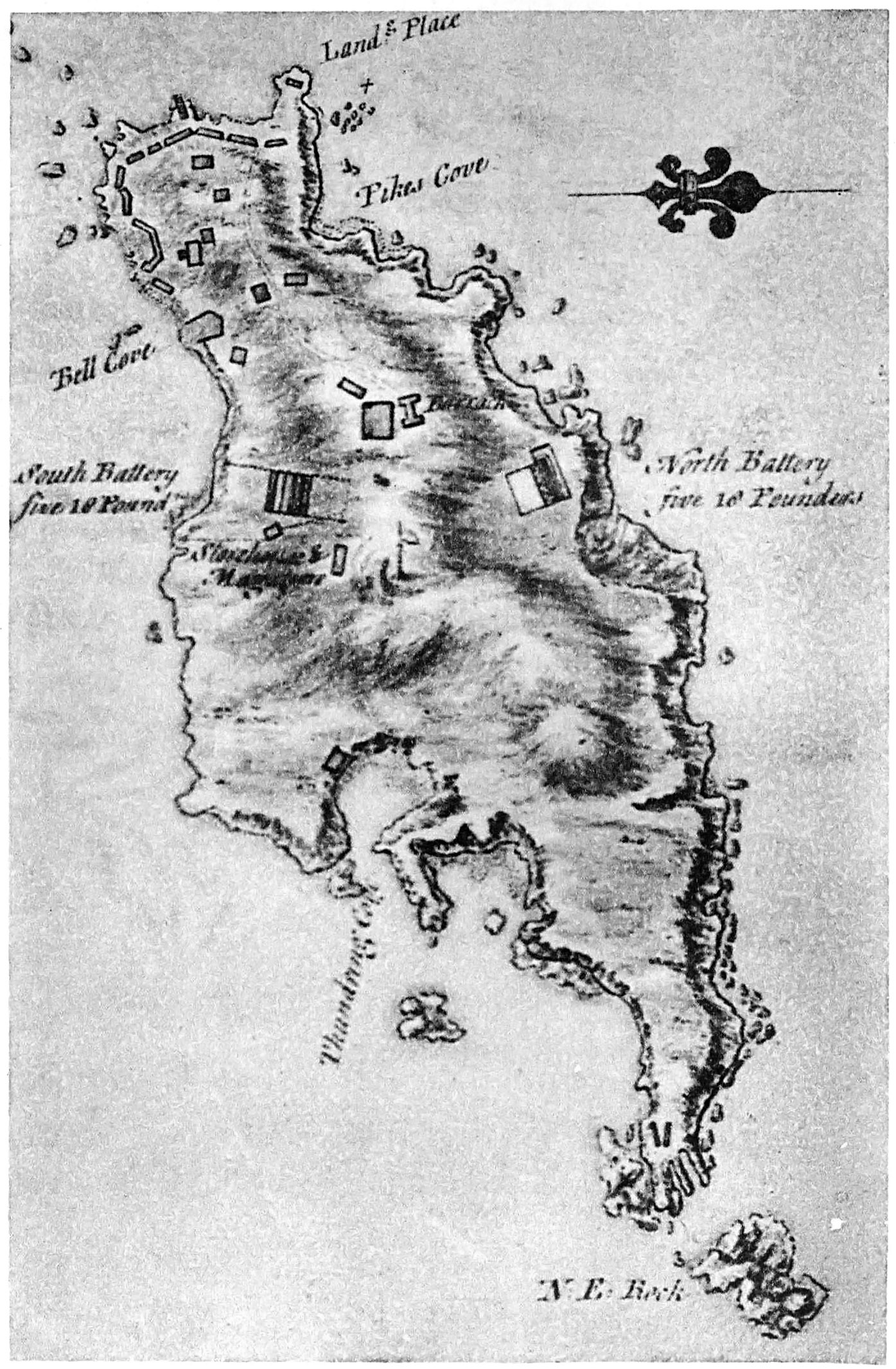
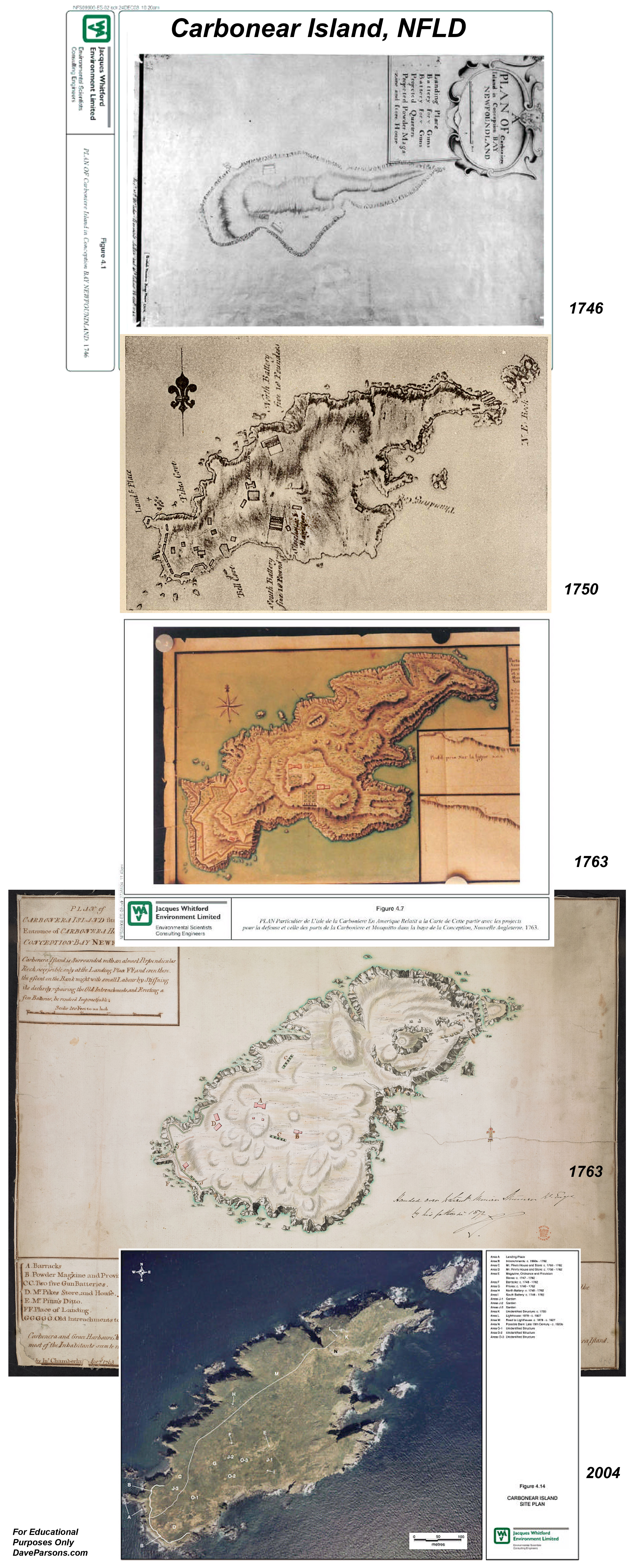
The map is a particularly skilful representation of the island, showing stylized vegetation and relief pictorially and by shading. It also includes a number of buildings at the southwest end (possibly owned by Pike and/or Pynn and used for the seasonal fishery), as well as a line of Intrenchments along the edge of the embankment overlooking the Landing Place, two five gun Batteries, a Magazine and Storehouse, the I-shaped Barracks and Quarters with what is likely an adjacent Privy, a number of Gardens (possibly for vegetables) and what may be a Guard Room or lookout on the height of land at the northeast end of the island. A number of prominent landmarks are also noted, including Pike’s Cove, Thundering Cove and Bell Cove. From a historic resources research and development point of view, the plan of Carbonear Island dating to c. 1750 is an invaluable source of information for assessing the site’s archaeological and interpretative
potential.
Starting as early as the seventeenth century, when the over-wintering population of Newfoundland was still relatively low, inhabitants of the principal fishing communities from Ferryland in the south to as far north as Bonavista established temporary, makeshift fortifications on islands and defensible headlands where they could retreat to in times of conflict between Britain and France in their ongoing effort to gain control of the lucrative fisheries. It was felt by the British government at the time that the many scattered settlements along the coast were indefensible and expendable, with the migratory and naval fleets being the only reliable means of defence of the industry. Consequently, the earliest fortifications were "civilian" in nature, erected by the planters themselves with little or no official sanction or support
from the Crown.
The earliest confirmed reference to the use of Carbonear Island for civilian defence purposes dates to the winter of 1696/97, when 300 individuals from the area (a number which may be high) were reported to have established temporary facilities to secure themselves and their “effects” against attack from French soldiers and allies under the command of Pierre Le Moyne d’Iberville. Despite a number of attempts by the enemy to land, all efforts proved unsuccessful. Ultimately, they departed for Placentia, after having destroyed most of the communities and fisheries infrastructure in Conception Bay. Over the course of the conflict, d'Iberville caused extensive damage in English Newfoundland. He burned over 30 settlements, killed approximately 200 settlers and took some 700 prisoners, 400 of whom were transported to augment the populations of Quebec & Acadia (Ransom 2000). In the early eighteenth century, during Queen Anne’s War (notably in 1705), French troops again attempted to overtake Carbonear Island after residents had retreated there following the outbreak of hostilities. Even though the resident population of Newfoundland during that period was still largely responsible for their own security and the protection of the fishery, the Crown was providing an increasing degree of assistance in the form of arms. Correspondence indicates that approximately 130 people from the area resided on Carbonear Island during the winter of 1711, a number that may represent a reasonable average for the entire conflict. Despite considerable efforts to overtake the island, similar to the previous war, all proved unsuccessful; a fact that speaks volumes to the ease with
the island could be defended.
Top of Carbonear Island on August 12, 2025 looking southwest with the foundation remains of the old lighthouse. Dave Parsons photos.
The Treaty of Utrecht in 1713 brought relative stability to Newfoundland and little is known about the use of Carbonear Island during that time. It is reasonable to suspect, though, that similar to other temporary civilian fortifications, those on the island, no longer being required, rapidly fell into an advanced state of disrepair. There is a strong probability, however, that it continued to be used for the seasonal fishery and for small-scale agriculture.
The outbreak of war in the 1740s saw a resurgence of activity and, for the first time, a number of facilities were designed and constructed on the island by the Board of Ordnance under the direction of Royal Engineers, thus marking a notable transition in the way government viewed protection of the Newfoundland fishery. Similar works were also constructed at Ferryland and Trinity, Trinity Bay. Included on Carbonear Island were: a Barracks and Quarters; Provisions Storehouse and Magazine, as well as two five-gun Batteries of 18-pound cannon. In 1762, when the French ravaged a number of the
principal fishing communities along the east coast of Newfoundland, the facilities on Carbonear Island were entirely destroyed, along with a number of privately owned buildings, possibly used a part of a fishing room. It was reported that several of the canon at the two batteries were thrown over the cliff into the sea where they remain to this day. This notable event marked the end of the use of Carbonear Island for defence purposes. During the American Revolution of the 1770s and the War of 1812, fortifications were established at Carbonear and Harbour Grace.
1709 Petition to Queen Anne from Carbonear and nearby residents sheltering at Carbonear Island asking for English support from French attacks. Signed by George Davis, Thomas Moores, Thomas Pike and other locals. Author colorized black and white Queen Anne document scan from David Pike's Family History and Genealogy Resources Page. Book page from Encyclopedia of Newfoundland in the Memorial University of Newfoundland.
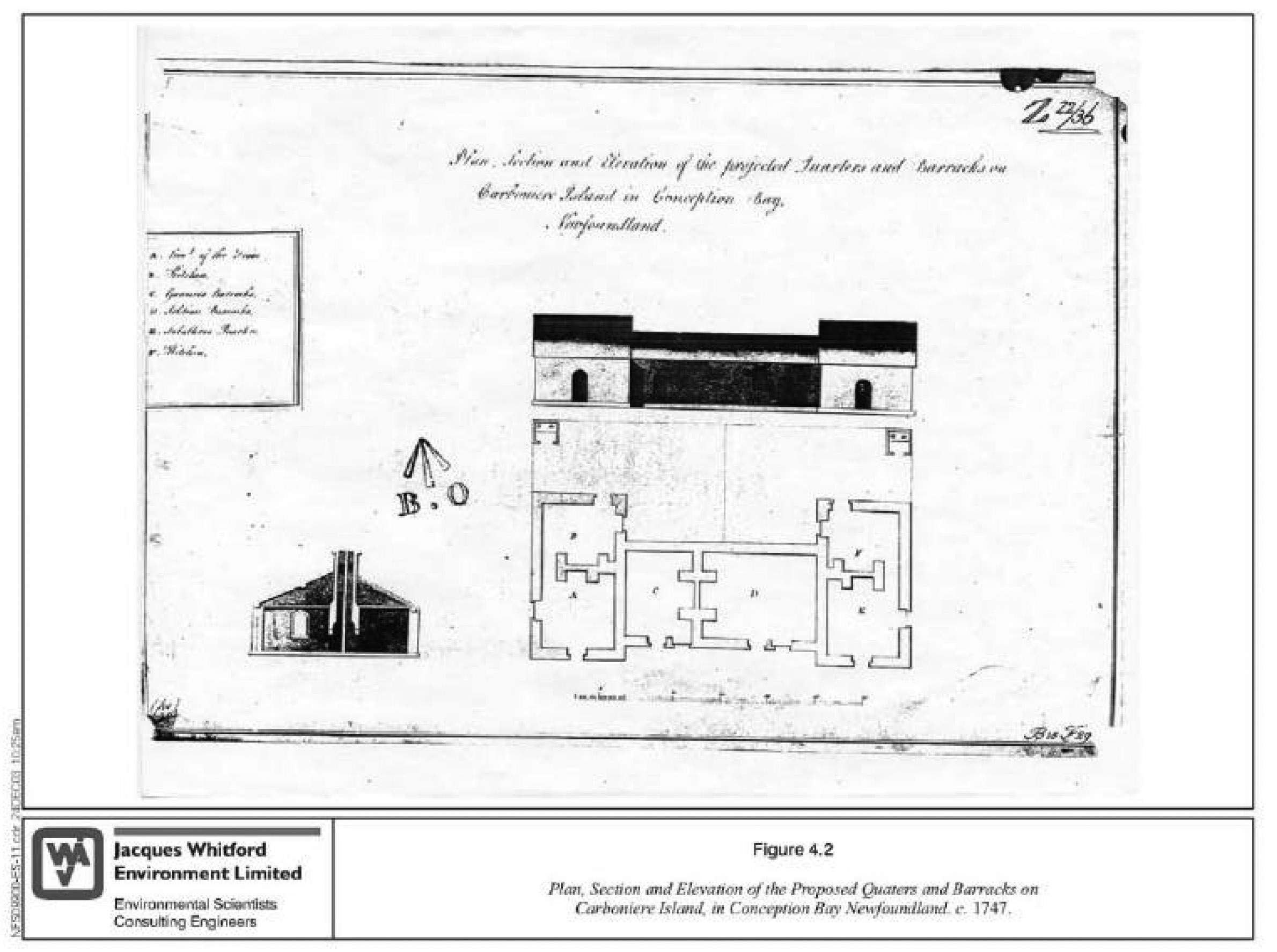
Sometime shortly after the c. 1746 overview plan of Carbonear Island was drafted, a detailed architectural-type drawing of a Barracks and Quarters proposed for construction was also completed by the Royal Engineers. The drawing indicates that the building would consist of an elongated central section with two adjoining rooms, with wings or extensions projecting off either end, resulting in a more or less I-shaped structure. Between each room would be partition walls with chimneys, with brick fireplaces on either side. Based on the proposed wall thickness, it appears that the Barracks and Quarters would be constructed mainly of stone, but with wood-framed and sheeted gables and roof. Slate or wooden shingles may have been used on the roof, and parts of the exterior were likely sheeted with clapboard (Figure 4.2).34 The drawing entitled, Plan, Section and Elevation of the projected Quarters and Barracks on Carboniere Island in Conception Bay, Newfoundland, includes a legend which enumerates the following: A - Lieut. Of the Union, B -Kitchen,
C -Gunners Barracks, D - Soldiers Barracks,
E -Subalterns Quarters, F -Kitchen.
From Carbonear Island Archival Research Project - June 2004
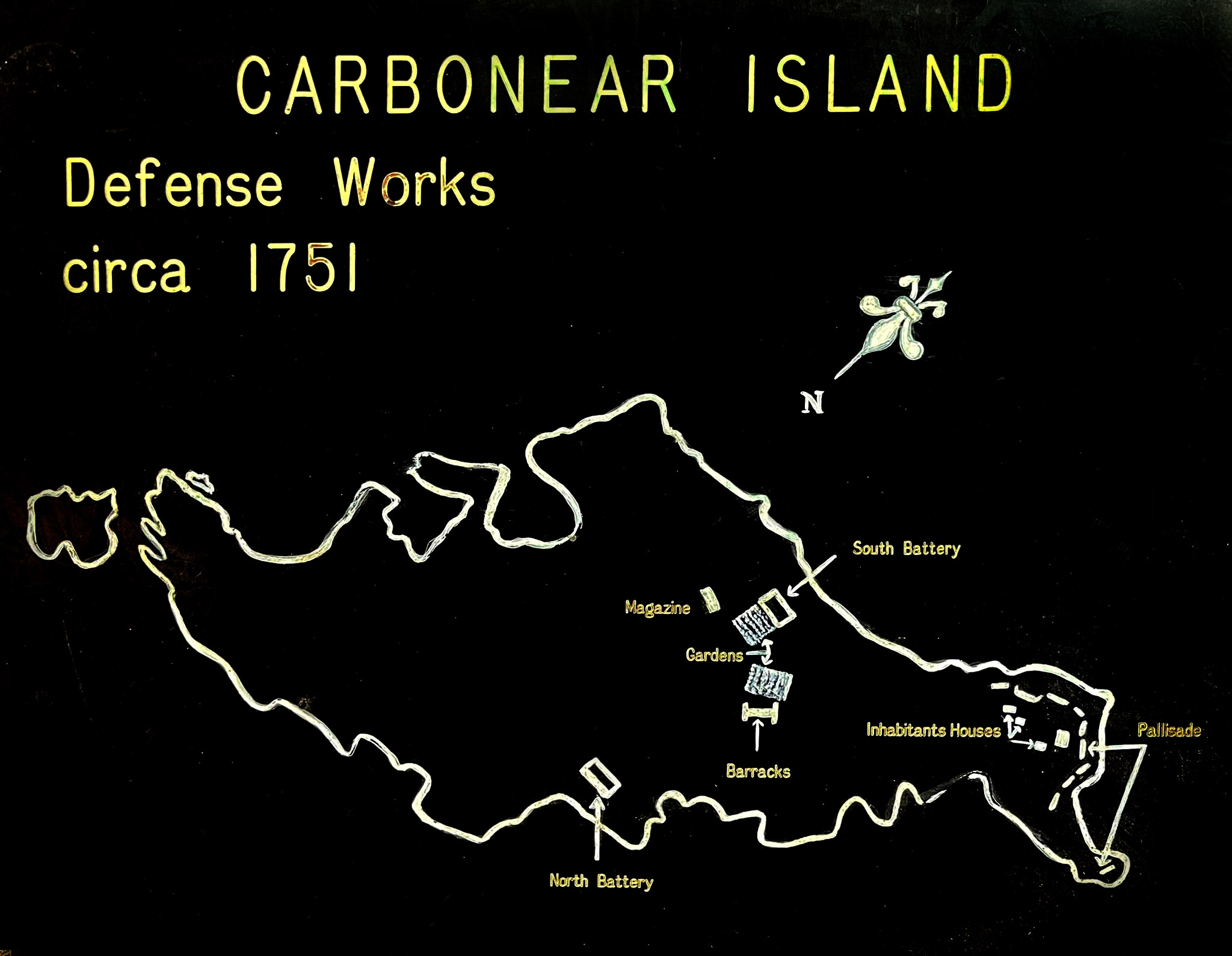
Basic outline drawn from the 1750 map. From Carbonear Heritage Society public Facebook page.
Entitled, PLAN of CARBONERA ISLAND situated at the Entrance of CARBONERA HARBOUR in CONCEPTION BAY NEWFOUNDLAND, it includes a notation at the base indicating that it was the work of Chamberlain from April 7th, 1763. Essentially, it is a copy of the slightly earlier drawing by de Barres and contains more or less the same information. It shows a clearer view of the island and what was in place and
destroyed during the French occupation, but without the overlay of the facilities proposed for constructed by the British Military.
potential.
The Map of Carbonear Island shows the remaining gun batteries, powder magazine, barracks, Mr. Pike's and Pinn's stores and houses as well as the landing area which were entirely "Burn'd and Destroyed by the French on the August 1762." The description continued with "Carbonera and Grace Harbours, Musketa, Crokress (Crockers), and Clowns Coves, can at any time muster up above 600 Fighting Men, these with their most Valuable effects, might upon Emergencies retire on Carbonera Island. most of the Inhabitants seem to remain Wealthy, notwith standing their Considerable loss sustained by the Destruction of their Fish Flakes, Store Houses etc." (Map reproduction courtesy of the Norman B. Leventhal Map & Education Center at the Boston Public Library)
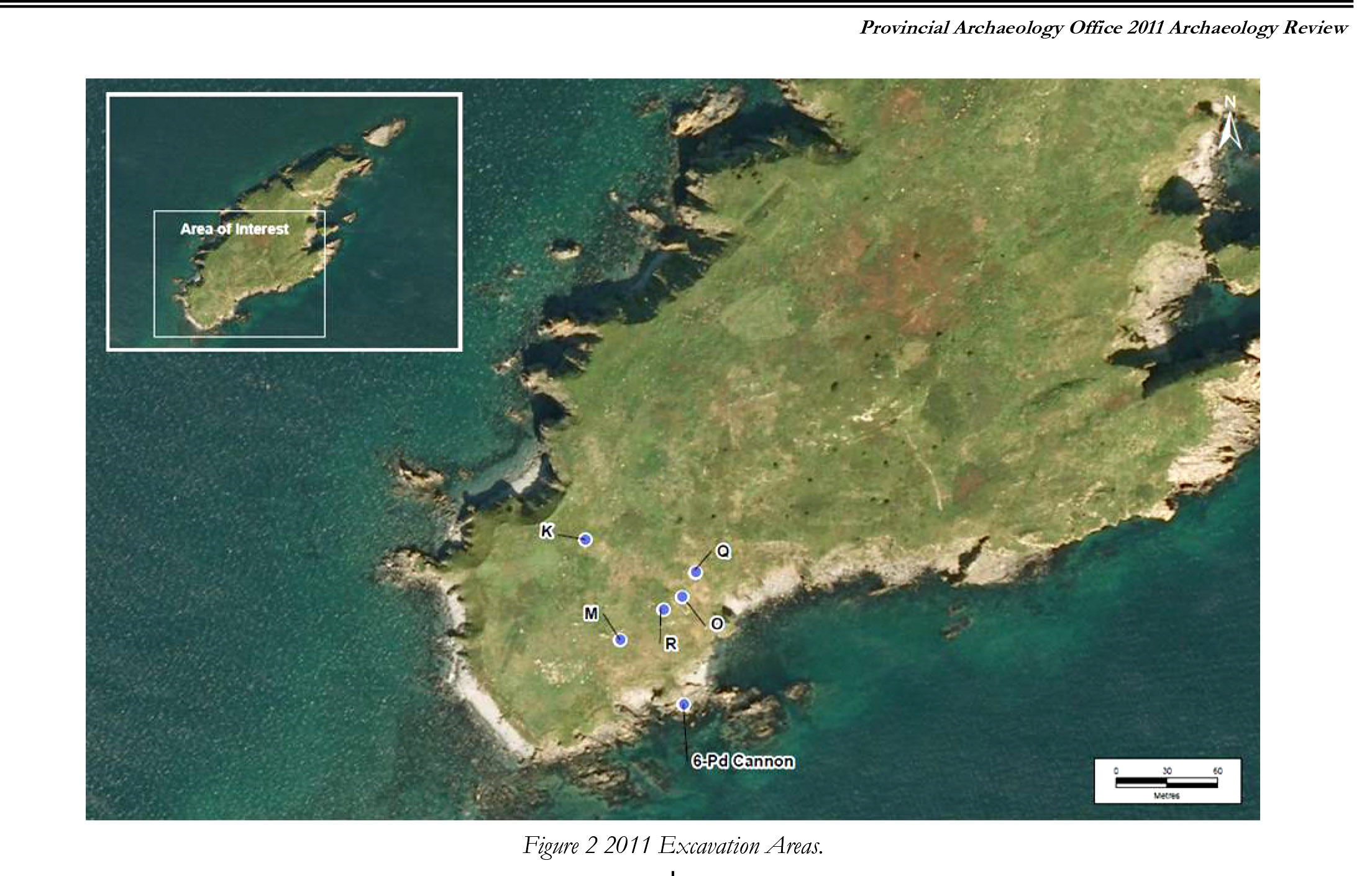
Below, artifacts revealed from 2010 and 2011 excavations on Carbonear Island (Photo credit labeled, however original source no longer available online). Pipe stems, broken pottery, and cannons were some of the remains left behind. From a 2010 archaeological report, "Over and above clay smoking pipe fragments, the predominant artifact-types recorded on Carbonear Island during the 2010 archaeological survey were tin-glazed materials and South Somerset-type course earthenwares." Learn more about the area's history with Archaeology in Newfoundland and Labrador Annual Report Series.
The report continued:
"Key findings of the 2010 survey include the remains of at least four 18th century buildings, two of which appears to have had large stone chimneys and brick-lined hearths – a structural element that could indicate a "winter occupation". Of note is that testing in the vicinity of the largest of these structures revealed, at the base of several test pits, artifacts that appear to date to the latter part of the 17th century. Thus it is possible that this particular location on the island had seen either an extended (or more than one) period of occupation.
"Other findings include a deep deposit of ceramics, glass and smoking pipe fragments dating from the 17th and 18th centuries, situated in a relatively secluded location, protected from the north wind and facing south overlooking Conception Bay. While not confirmed, the quantity and dimensions of iron nails, and the range of other material culture unearthed at this site, almost certainly indicates a building – very likely a dwelling. In an adjacent hollow, protected from the wind by boulders and cliff, a deposit of tin-glazed artifacts, pipe fragments and nails suggest the remains of yet another small structure of an unconfirmed function."
"Another key find of the 2010 field study was a relatively small earthen platform thought to be a gun emplacement, possibly for 6-pound cannon. Because the structure is not shown on any military plans from the 18th century (and there are several), it is reasonable to suggest that this earthworks pre-dates the mapping of the island and is therefore from the 17th or early 18th century "civilian" period of occupation. Clearly, further field research is required to confirm this possibility."
When cod were "running plenty" fishermen would work night and day as children would gather the wild blue berries from the hill sides. "Time is fish and fish is money" was once a common saying for Newfoundlanders. Wool-sweatered fisherman in bulky oilskins and boots would ply the coastal waters in dories, skiffs and four and five man long liners, hand-jigging for cod or haul in gill and trap nets from dark waters below.
In a humorous and descriptive account from his book, "From the Nart Shore" of a 1915 inshore fishing excursion, longtime Flatrock resident and author, Herbert L. Pottle explains the competitive and delicate intricacies of "trap berths," fishing and loading, or in his case, overloading a boat in the waters near Carbonear Island:
"Shore fishing was invariable a short season - a few frantic weeks. It was when I was about eight years old that the date for setting cod traps was changed from 25 May to 5 June. Father used to figure 100 quintals of fish by 12 July (Orangeman’s Day) as a fair catch up to that date. A total "voyage" of 100 quintals per man was considered "a good summer". And a quintal of fish for a barrel of flour was a local equation signifying rough justice.
Getting on the water to catch the fish, and being able to cure it once ashore, were vital items in our current account…
My father’s crew as I have said, were four men in a boat…
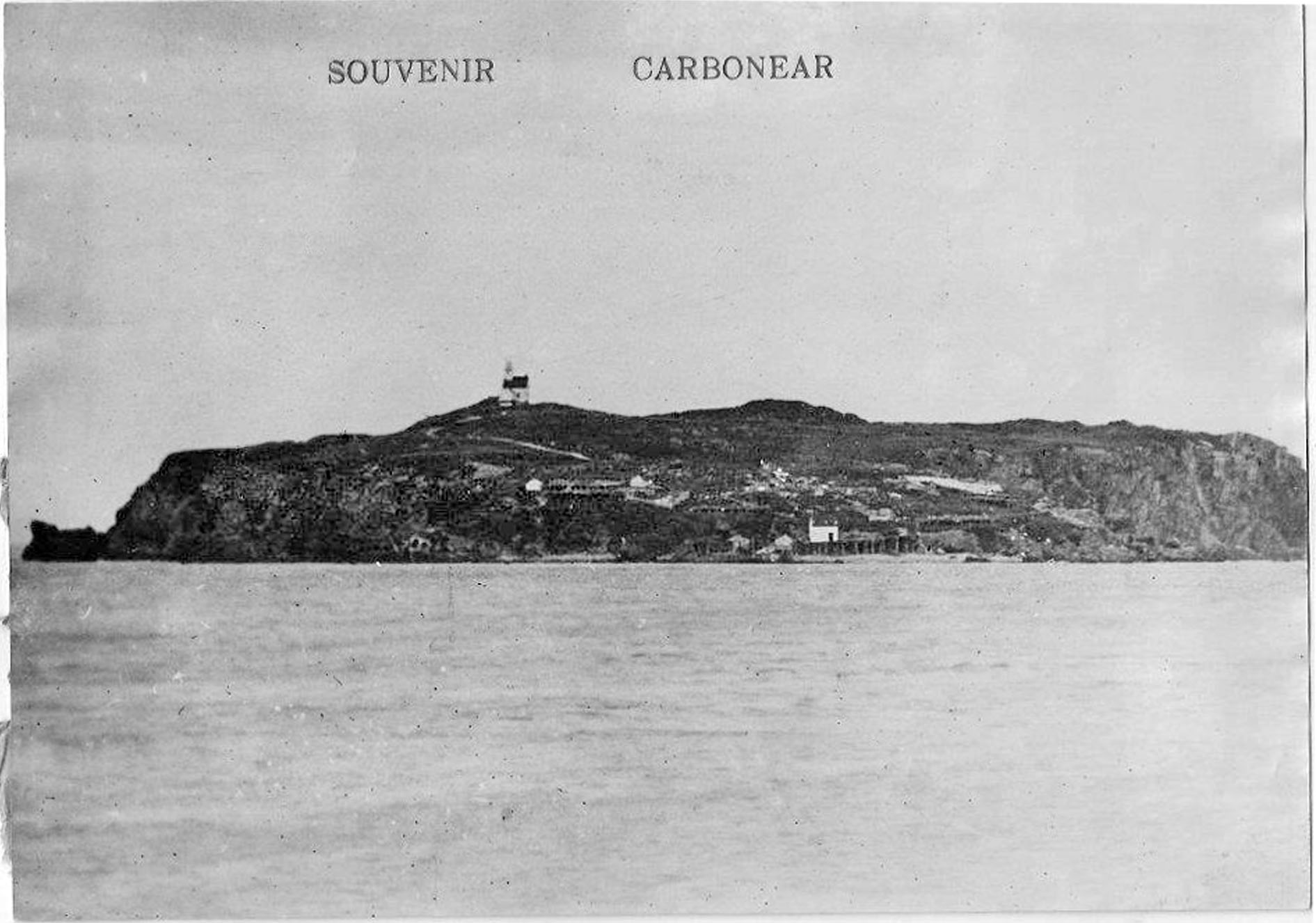
Carbonear Island postcard taken about 1900 with the lighthouse (MUN link) on the high point. Two summer dwellings with multiple stages stand just below and at the waters edge, a wharf with storage shed.
According to a longtime Carbonear resident "That old lighthouse served well, it's storm windows were put on our house in the winter & in use until the 1970's!, Taylor's of B/Hope grazed their sheep over there for years, Harry & his brother Pearce tended to the automated lighthouse until they retired & their sons Harry & Nelson took over, along with Hr. Grace island & the beach at Hr. Grace." (Photos from Public Facebook groups - Freshwater, C.B., Newfoundland)
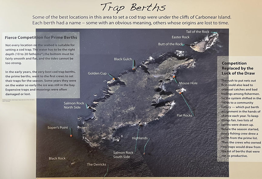
Securing trap berths was something of a lottery but mostly a loss of sleep, especially in the case of very good berths. What usually happened was that the more powerful crews tended to make a pitch for the choice fishing locations around Carbonear Island well ahead of the trap-setting day - sometimes as much as a week in advance. This meant "lying to" on the berths during the day - anchored as a rule, which was against the law - and huddling up in some inlet of the island at night. Being thus exposed in an open boat for several days and nights, even by shifts, in late May and early June, was an outdoor exercise tantamount to an ordeal.
The "inside" berths - that is, the ones nearer the shore - were not so competitive, since most of them had been taken by the same crew year after year, so that they became known, for example, as John Charles Everly’s berth (Mad Rock), George Marshall’s (Peter’s Finger), or Ned Pike’s (Bradley’s Rock). The rest were more or less up for grabs. In order to make sure of one of the best of these one year, father was delegated to go after it, while the older brothers were in major action at the high part of Easter Rock, Carbonear Island. It was Sunday night, after church, when my church-going father and I pushed out punt off Broad Cove beach. Apparently he had reckoned that the better the day the better the deed. We held the berth overnight with part of a "fleet" of gear - that is, part of a complete set of anchors, buoys, moorings - father "keeping up" (keeping the punt on the berth, sculling into the wind), and I bailing water.
Our larger cod trap was about 60 fathoms "on the round" (the total length of the four sides, the perimeter) and about 12 fathoms deep. The fish are led into the trap by a "leader" - a straight wall of twine - in such a way that, once the fish are inside, they tend to swim around and around in the same free space. The trap is winched or manually pulled from the bottom by four ropes, and as the twine is drawn up out of the water it is "paid away" (let go again), so that the area of the trap in which the fish are swimming is reduced until they are "dried up" at the surface. In the case of a big haul, once the boat is loaded, the rest of the fish are "bagged off" - that is, they are shifted from the trap into a large knitted, twine bag, then tied to the main trap and let float there until later picked up."
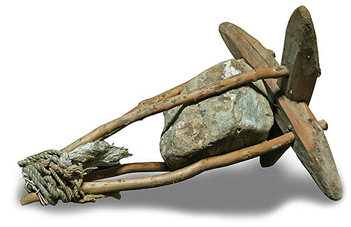
Homemade anchor weighted down with a heavy stone known as a "killick."
After a particularly good haul, no one in their crew wanted to say "when" to stop taking fish aboard. As a result:
"Down, down settled the boat, inch by inch, quintal by quintal, fish by fish, until the water was lapping the gunwales. Probably some warning word from father or Art that we were going under stayed the overloading hands…
How we ever managed to stay afloat for so many summers, and still reach shore in our sinking condition, I cannot begin to divine. I recall one such hazardous trip when we loaded up (or down) at the "Flatrocks", a particularly good berth on the far side of Carbonear Island, just off the lighthouse. Coming through the "dullifer" (thoroughfare) we were suddenly espied by Reuben and Albert Pike, then hauling their trap at "the Mouse Hole". Once they caught sight of us - what there was of us above water - they dropped everything they were doing and just stared at us, puzzled and anxious, until we had steamed away."
(From 1983 Book - "From the Nart Shore" - Herbert L Pottle - pgs. 92-94 - could not contact publisher via phone or text for use of quotes - please consider my educational usage a "review" of the book!)
Other Freshwater fishing families commented on their experiences and fishing spots in the treacherous waters outside of Freshwater Cove: "My father's fishing spot was the trap moored to the rocks - they always called it dark gulch." Another resident remembers going out in the boats as a kid - "Growing up in Freshwater, we lived out in the punts in the summer… no life jackets, yet I never knew anyone that drowned. The boys would rock the boats though, to scare the girls. We did not row out as far as Carbonear Island, for obvious reasons such as wind changes, tides etc. but once every summer, we went out in a fisherman’s motorboat, for a picnic on Carbonear Island. It’s a fabulous memory." (Quotes from Public Facebook groups - Freshwater, C.B., Newfoundland)
Some of the best fishing spots or cod trap berths around Carbonear Island. A fathom is six feet. (Photo from Public Facebook groups - Freshwater, C.B., Newfoundland)
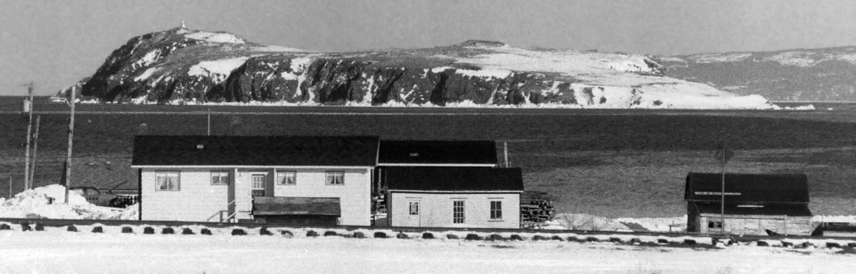
A zoomed in photo was taken from the south side of Carbonear Bay along the railroad. The sloping Island with steep cliffs and hazardous currents is tricky to land on by boat. Photo from Decks Awash April, 1987 Magazine in Memorial University of Newfoundland
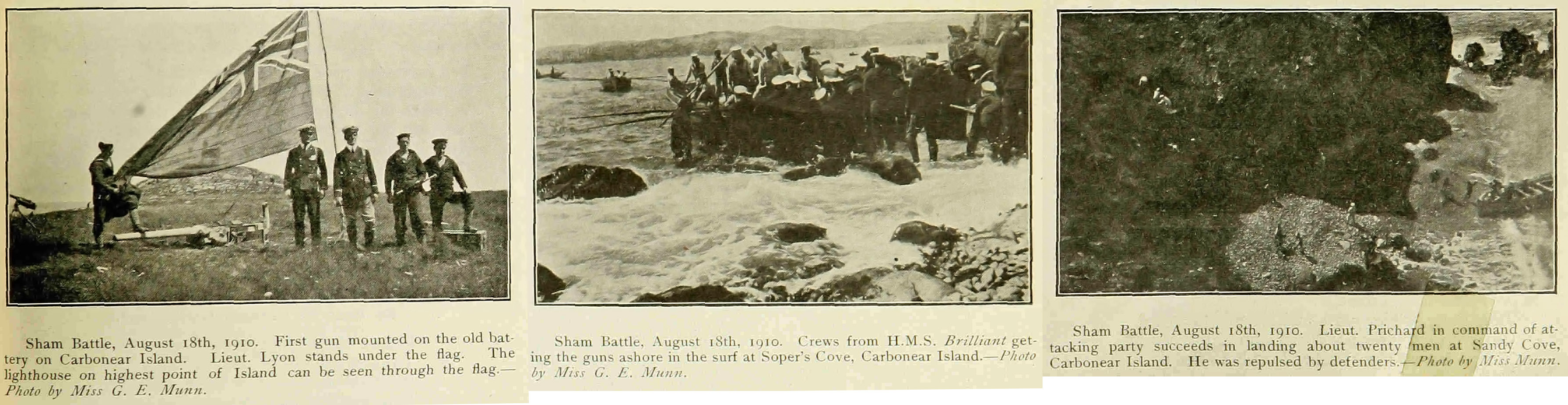
Commemorating the 1696 defense of the island by 200 fishermen against the French Navy, soldiers of the British H.M.S. Brilliant performed a sham battle invading and defending the island on August 18, 1910. Article in The Newfoundland Quarterly, October, 1910 issue - from the Memorial University of Newfoundland
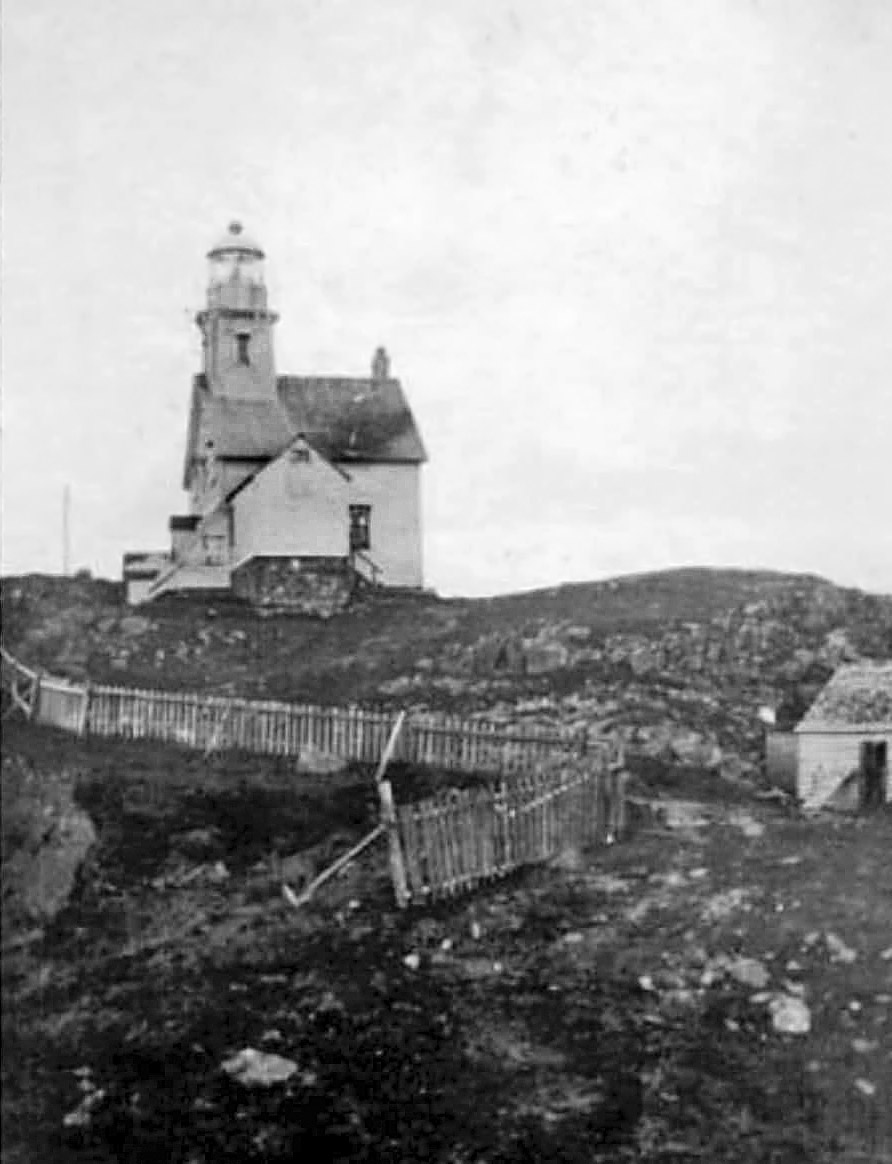
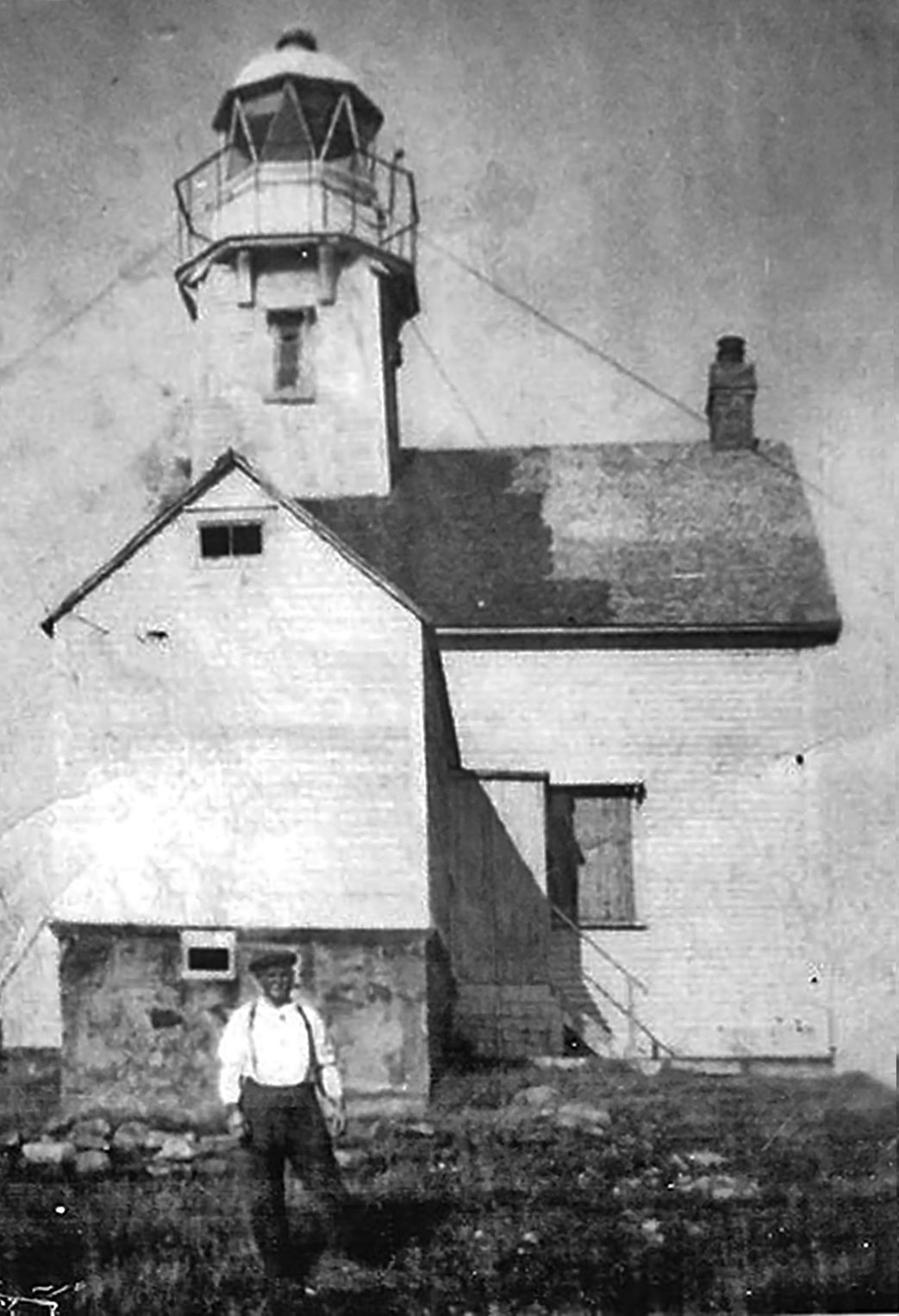
Standing on top of the islands highest point, the Carbonear Island lighthouse, built for year round residency in 1878 was attended by Henry Forward for about 45 years. He stands in front of the lighthouse, stabilized with cables about 1890. Henry passed away in the lighthouse residence in 1928 at the age of 71. The lighthouse ceased operating as an attended lighthouse the next year.
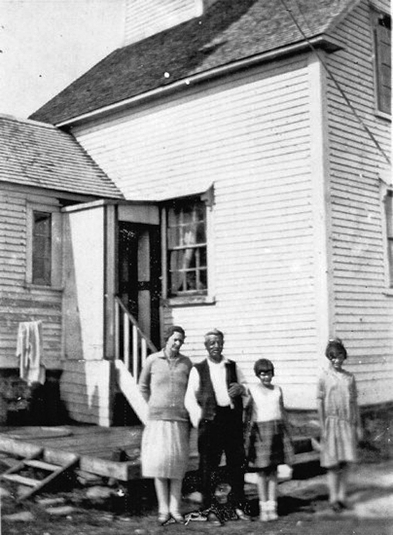
Henry Forward stands with his wife Elizabeth Dean and their grand daughters, Lily (on left) and Violet Taylor, at the front of the lighthouse entrance about 1925. (Photos from Public Facebook group - Freshwater, C.B., Newfoundland)
Taken close to where the 1890 photo was taken, today the spot houses the automatic lighthouse and lots of seagulls in 2025. B/W Photo from Memorial University of Newfoundland.
The remaining foundation of the lighthouse Henry Forward stood in front of nearly 100 years ago.
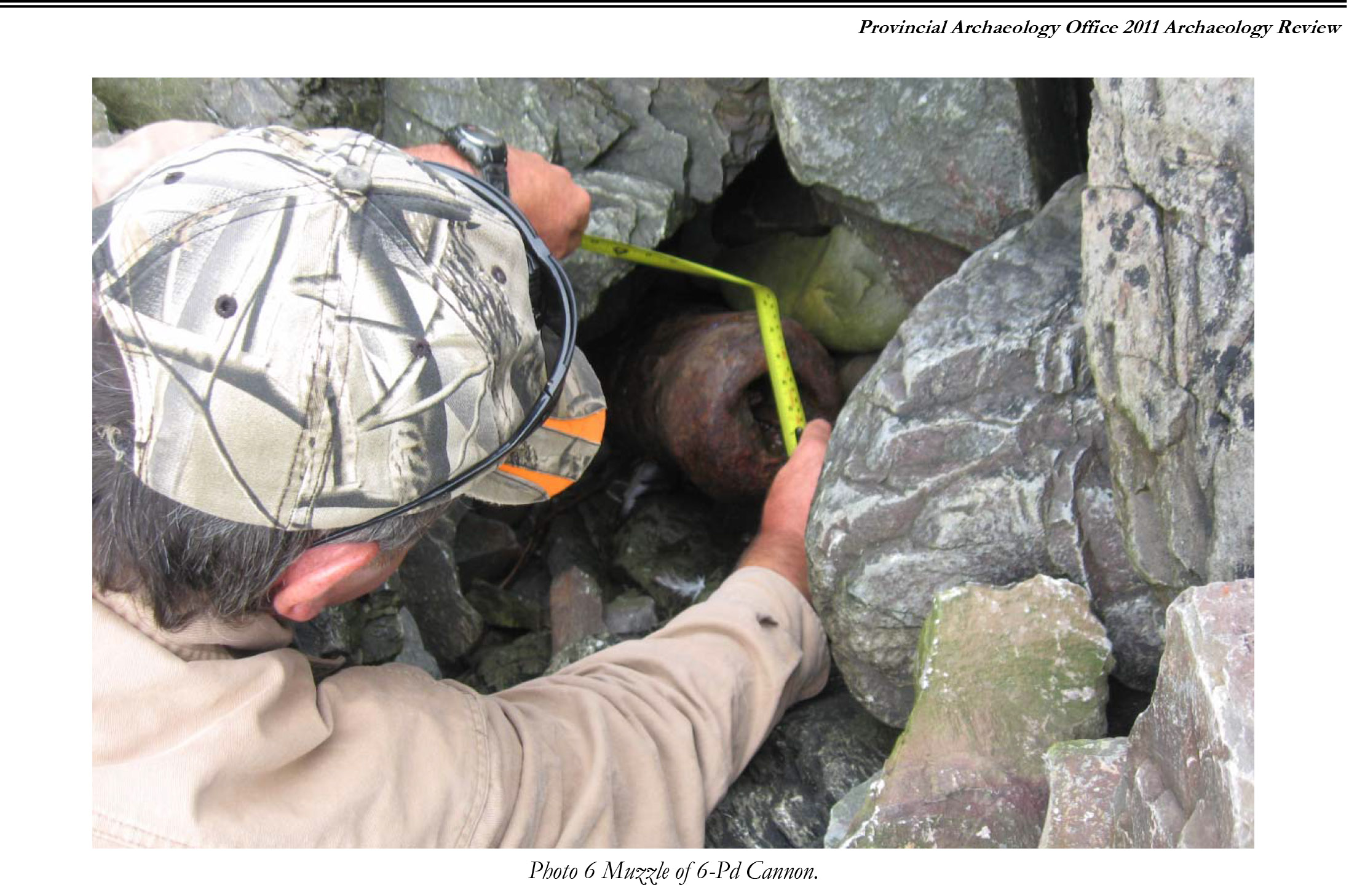
Burried under heavy rock along the cliffs edge, remains of a 6 pound cannon peeks out among the feathers. - From Provincial Archaeology Office 2011 Archaeology Review - February 2012 Volume 10
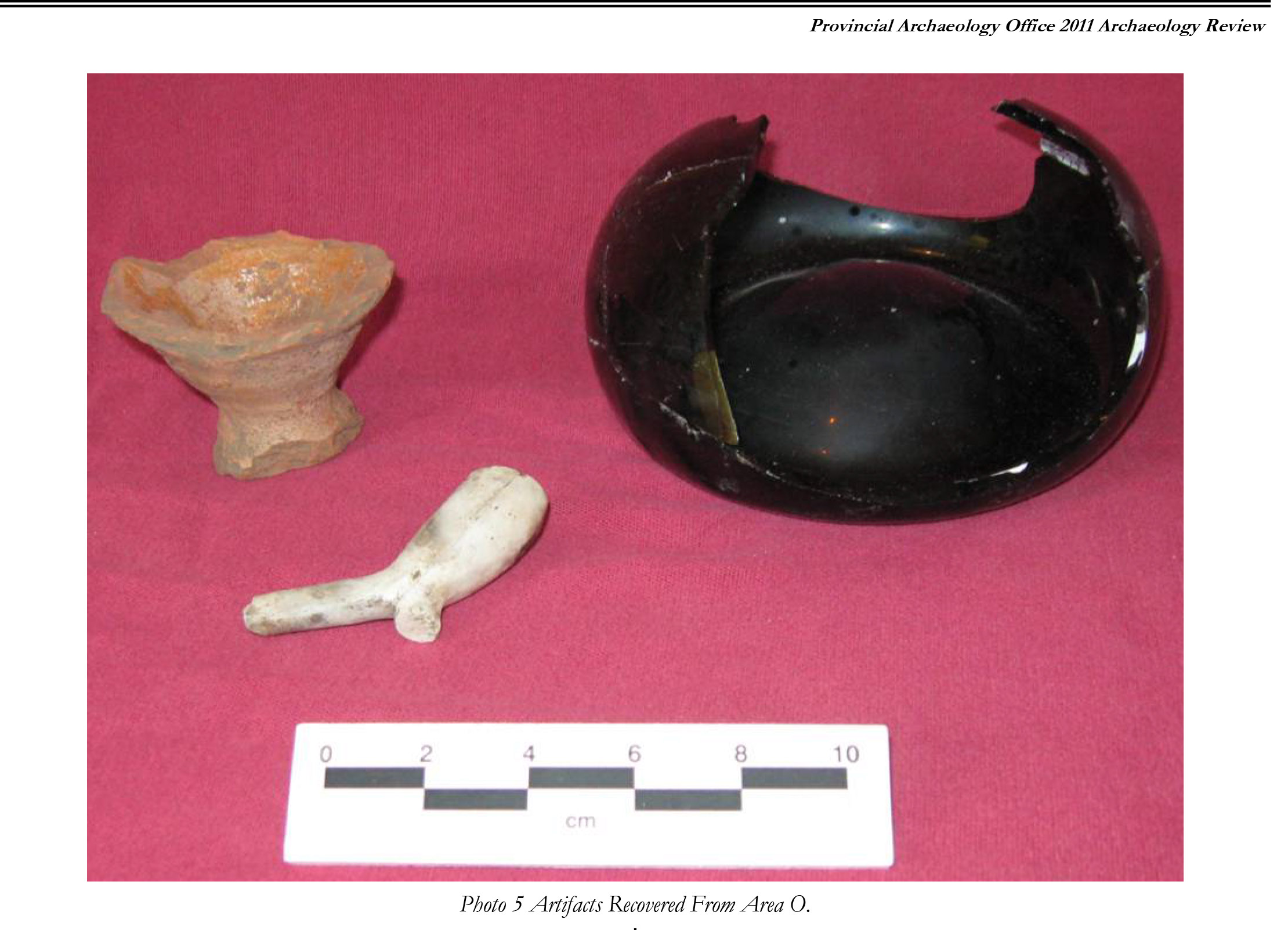
Clay pipe and pottery fragments. - From Provincial Archaeology Office 2011 Archaeology Review - February 2012 Volume 10
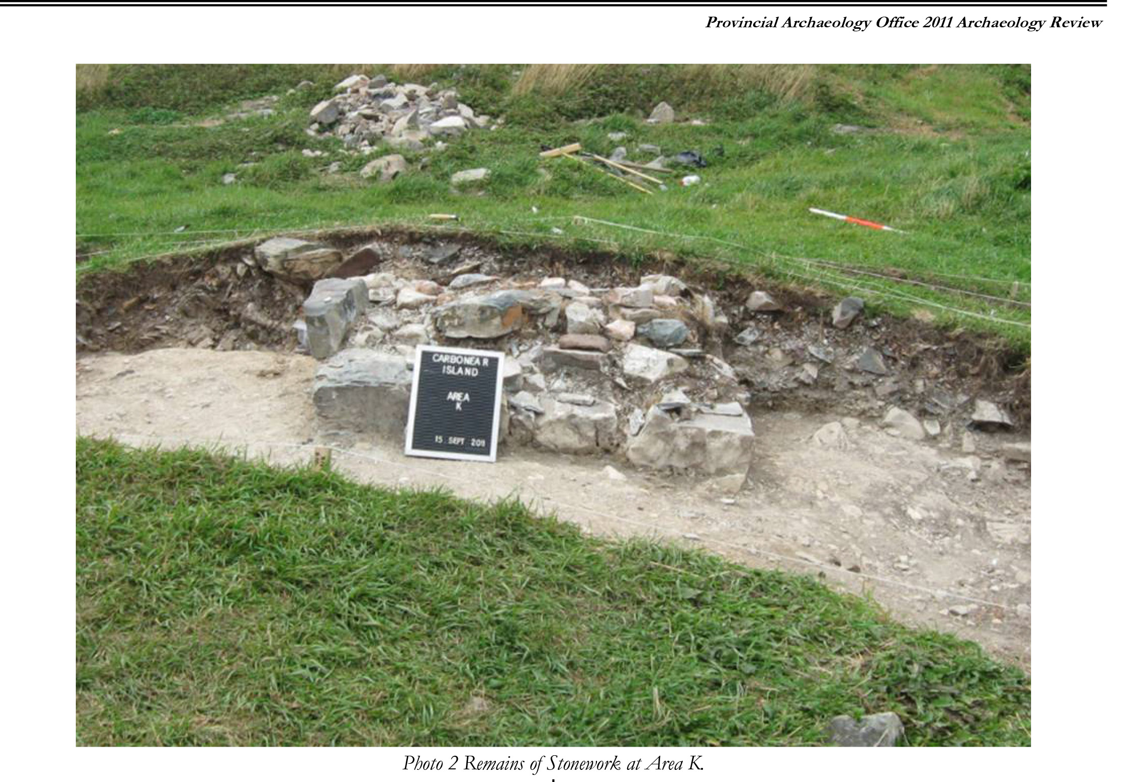
Stone work just under the surface. - From Provincial Archaeology Office 2011 Archaeology Review - February 2012 Volume 10
The island through the years.
More than 5,500 artifacts were unearthed during excavations on Carbonear Island, Newfoundland.
SHARDS OF IDENTITY - Ornamentum Magazine
Feature Articles - 20 June 2016
Article by Lorraine Flanigan
PIECING TOGETHER DOMESTIC FRAGMENTS
THE YEAR WAS 1697, and Pierre le Moyne d'Iberville led his French soldiers to Carbonear, one of the oldest settlements in Newfoundland, to set siege on the craggy, treeless, and dangerously inaccessible Carbonear Island where 200 English settlers had taken refuge behind protective earthworks.
"The civilian defenders of this island watched in sorrow as the French under d'Iberville burned Carbonear to the ground," says Florence Button. As project coordinator and one of a team involved in an archeological research project conducted on Carbonear Island in 2010 and 2011, Button catalogued the many artifacts left by the settlers who held out against the French. "I feel the sorrow of these courageous people as they watched their homes, fishing stages, and boats disappear in flames and smoke from the cliffs (of Carbonear Island)." The island was the only one in the area to hold out against the French attackers during this time, and it wasn't until war resumed in the mid- 1700s that the French finally defeated the settlers, burning and ransacking the island -and destroying their military defences along with their household effects.
Although the historical details of the battles that besieged Carbonear Island are clear, it wasn't until an archival research project conducted in 2004 by St. Philips, Newfoundland-based archeologist Roy Skanes that the island wasdocumented as a historic site of considerable significance.
"It's a unique spot in that it's a civilian defence area," says Skanes, which is unlike some other sites excavated in Newfoundland that have turned up many military artifacts. Not only was Carbonear Island primarily a civilian community, but it's been relatively undisturbed over time, Skanes explains. Despite some farming and a seasonal fishery, the impact on the original seventeenth-century settlement has been low -making it an unusually untouched site for archeological exploration.
Tobacco pipe fragments from Carbonear Island excavations.Photographs courtesy of Town of Carbonear.
During two summers of excavation in 2010 and 2011, fieldworkers unearthed more than 5,500 artifacts, including fragments of ceramics, glassware, tools, and even tobacco pipes. But the work had just begun for Florence Button and lab assistant Linda Saunders, whose tasks were to record the exact location of each piece, and then examine the fragments, identifying, describing, and documenting the type of materials and likely provenance of each before painstakingly trying to piece together the hundreds-years-old shards. To identify the ceramic pieces, Saunders, a trained production potter, would examine the type of clay -whether it had traces of mica or quartz or iron -its colour, and the glazes used. These were valuable clues as to the origin of the household items used by the settlers. Among the shards found on the site were the distinctive blue, salt-glazed Westerwald pottery from Germany. From Northern Italy, the site revealed samples of slipware, a decorative technique whereby a watery clay "slip" was applied to the outer surface of a vessel, usually in a contrasting colour, and either swirled with a feather, for example, to create a marbled effect, or by using the "sgraffito" method of scratching a design or pattern onto the surface.
Still other pieces hailed from Portugal, an important trading partner of the Newfoundland fishery town of Carbonear. In return for salt fish, the Portuguese ships sent wine in onion-shaped glass bottles -the pontil marks at their bases telling of the hand-blown techniques used in their making. Portuguese tin-glazed pottery was also discovered on the island, its distinctively bright-yellow glazed surface a popular -and cheap - way of imitating the fine
Chinese porcelain that was beyond the reach of any but the wealthy. "It was the Tupperware of years ago," says Saunders. The most exciting find for both Saunders and Button was the beautiful and distinctive agateware, a style developed in England that dates from the early 1700s. To produce the agateware found on the island, solid pieces of different-coloured clay were pressed together and cut into strips, and then placed into two-part molds, explains Saunders. After firing, the various colours of the clay formed distinctive patterns both outside and inside the vessel. This is a complex technique that fell out of fashion in the late 1700s, and here it was on Carbonear Island.
Agateware fragments of pottery found during excavations on Carbonear Island. Photograph courtesy of Town of Carbonear.
"This was a fishing community," says Saunders, "You're not expecting to see some of this fancy pottery." Unfortunately, agateware shards were just beginning to be found when the archeological dig of 2011 came to an end, and so only a few fragments remain housed in Carbonear's Railway Station Museum, which records the history of the island.
The most complete vessel Saunders was able to piece together was an amphora jar in a design typical of the Iberian Peninsula. "These were Spanish olive jars that came to a point almost like a seashell," Saunders explains. Determining which fragments belonged to a single vessel required lots of patience, she admits. "It's not like a jigsaw puzzle where you have all the pieces," explains Saunders. "You might have to wait: I put some together one year, and when they found other pieces the next year, I was able to fit those into what I had
started the year before." Nor is it an exact science. To hold the pieces together, Saunders used watered down school glue because it's water soluble, making it easy to take apart sections of an item if a new shard needs to be inserted or an existing piece must be removed because it was later discovered to belong to a different vessel.
Because of the clay material common to these jars, the fragments may seem to be from the same pot, but to distinguish one from another, Saunders would look for telltale marks of the potter, including fingermarks and the way clay would form patterns when thrown on a wheel. "You can see where the potter's hand rested and you could almost put your hand there," says Saunders. "You are touching something that somebody put together 400 years ago."
Through the thousands of fragments found on the island, the team slowly pieced together the lives of the small community that took refuge on Carbonear Island so many hundreds of years ago. "It was pretty harsh," says Skanes. Buildings were rough-hewn and the chimneys dry-laid without mortar. Until further funding for the project comes through, though, the site holds merely the tantalizing promise of further discoveries.
Lorraine Flanigan is a Toronto-based writer and editor who visited Carbonear, Newfoundland, in the summer of 2015.
See More Features and Travel
Destinations in the Gallery