Clown's Cove and Freshwater, Newfoundland History
With Its Independent Outport Families
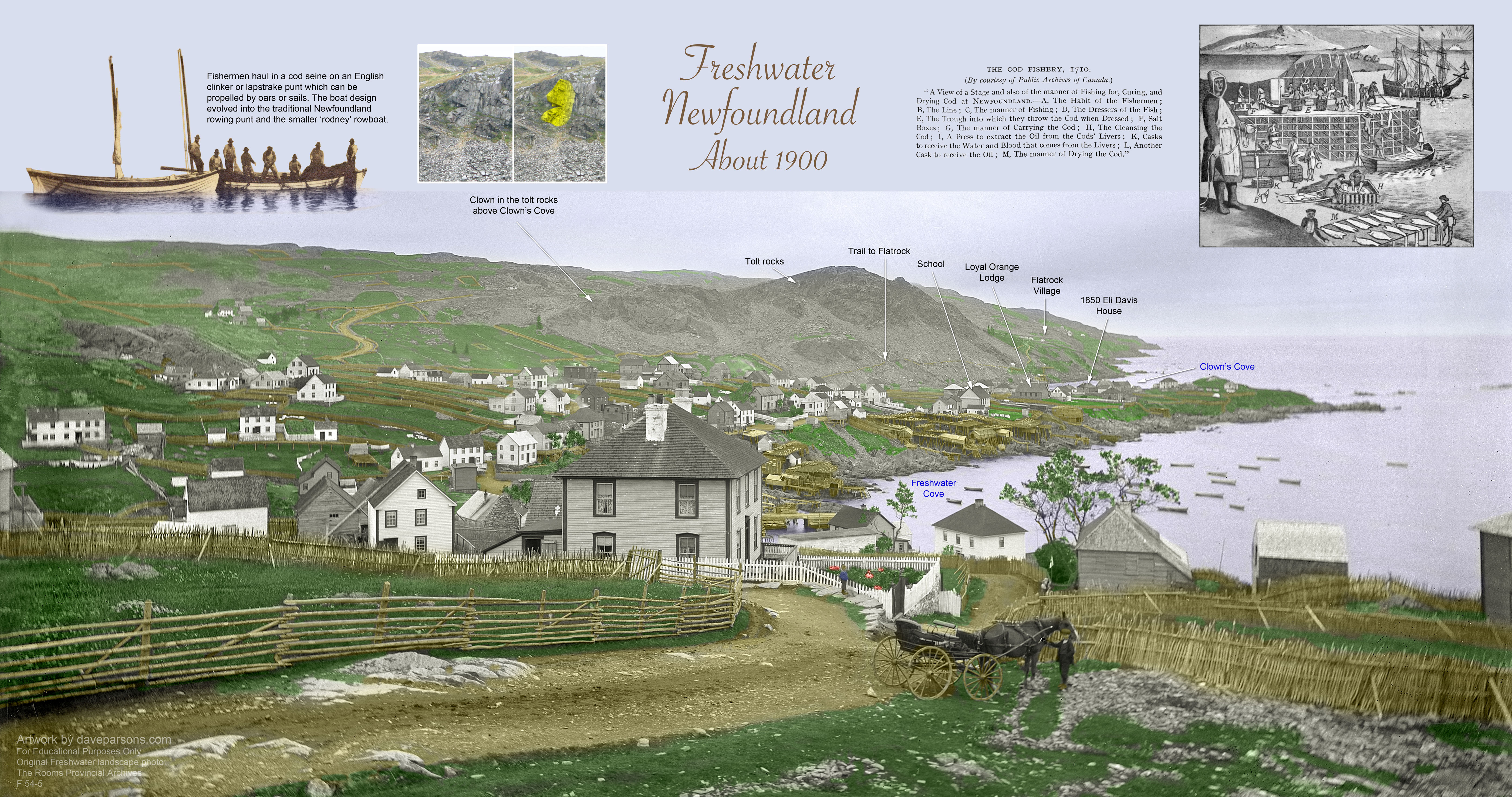
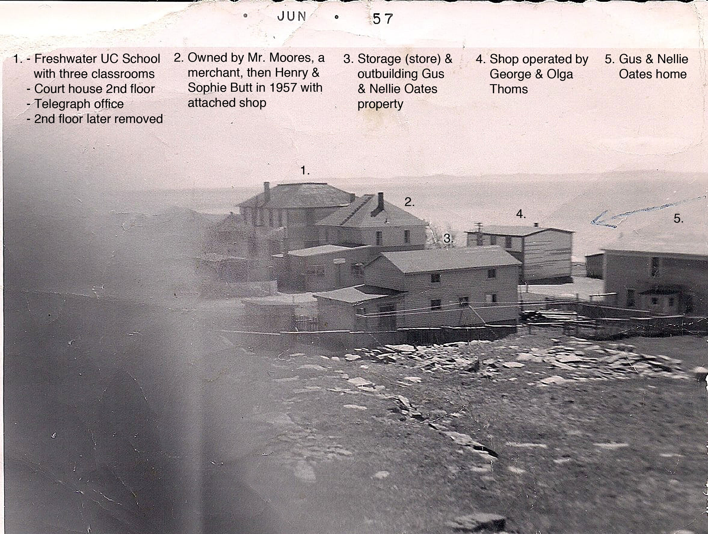
Sunrise from the rocky hill of Clown's Cove tolt (also called the Flatrock tolt) looking out towards Carbonear Island and Conception Bay on August 13, 2025. Flatrock and the cement remains of their abandoned 1954 school house stand on the far left and homes of Freshwater and Clown's Cove Head are on the right. (Dave Parsons photo)
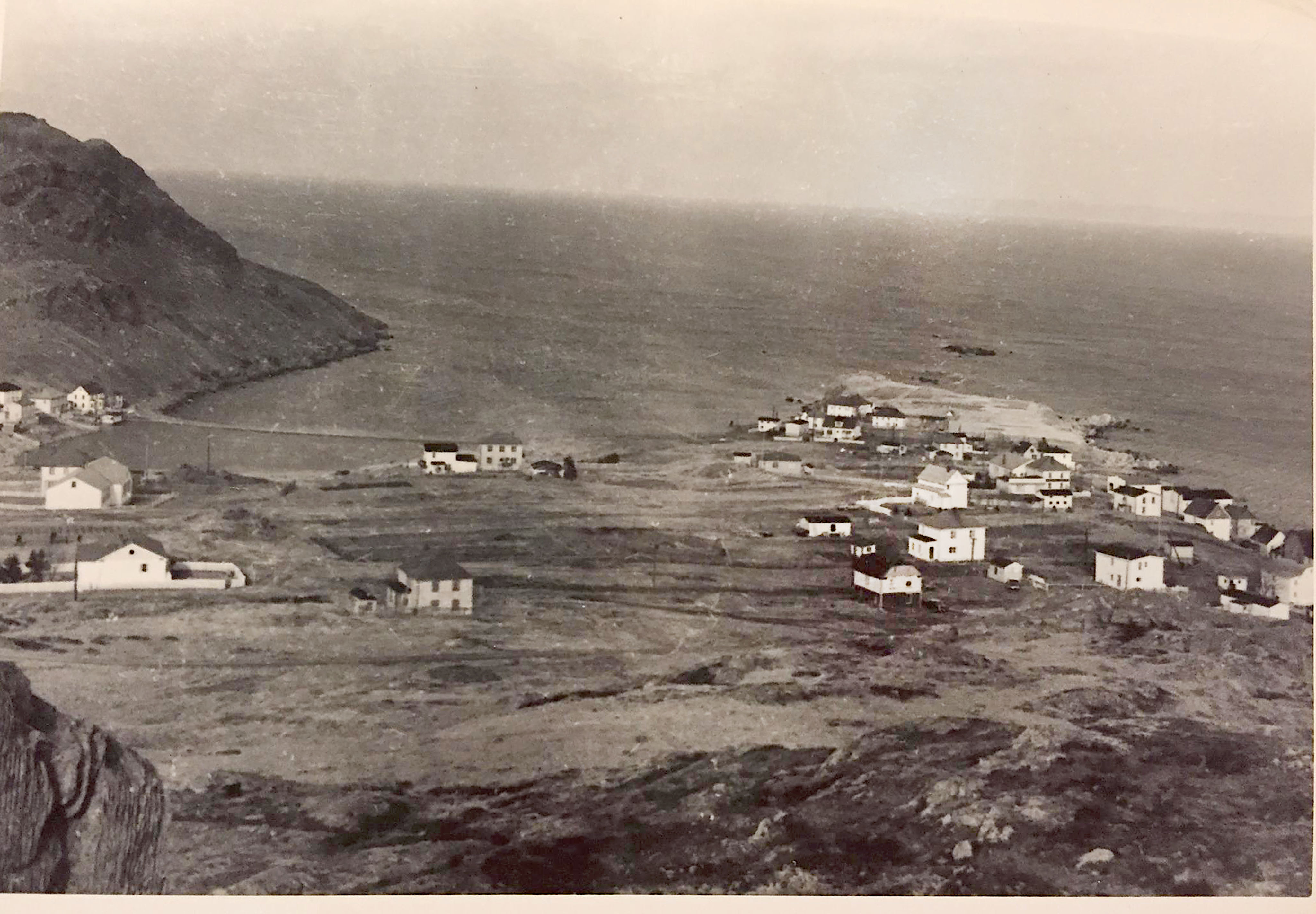
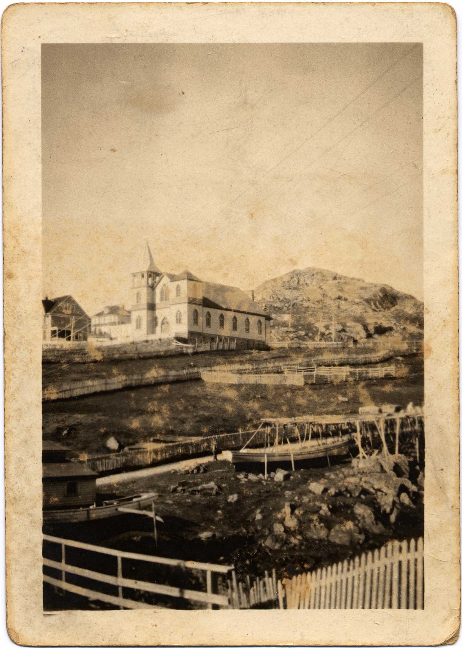
At sunset, a quiet neighborhood of homes and the Freshwater United Church built in 1926 overlook Freshwater Bay with the small wharf and remaining storage shed along the beach on July 20, 2006. The area was once a hub of commerce and fishing activity with a large wharf, multiple stages and schooners loading and offloading supplies. (Dave Parsons photo)
Audio - Durning low tide on a calm, foggy morning on August 14, 2025 waves gently wash ashore at Freshwater Cove as seagulls call out overhead. (Recorded by author)
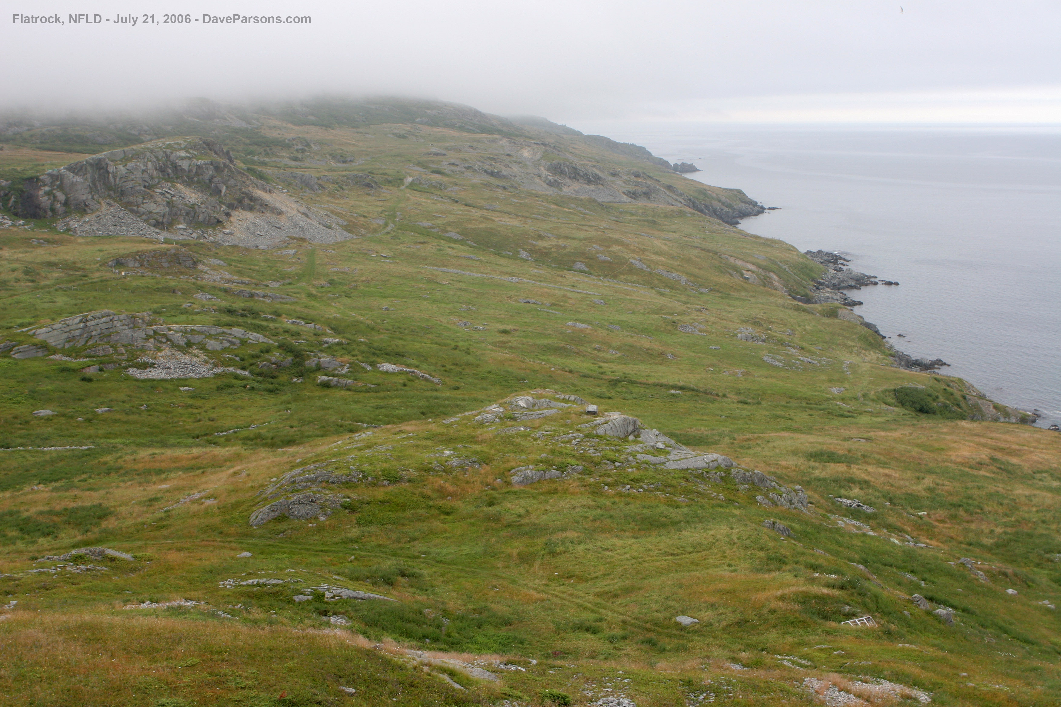
Stout ground hugging blueberries ripen as they perch on the side of Clown's Cove Tolt on July 21, 2006. For generations, families have picked the berries which have served as an important vitamin supplement to their diet.
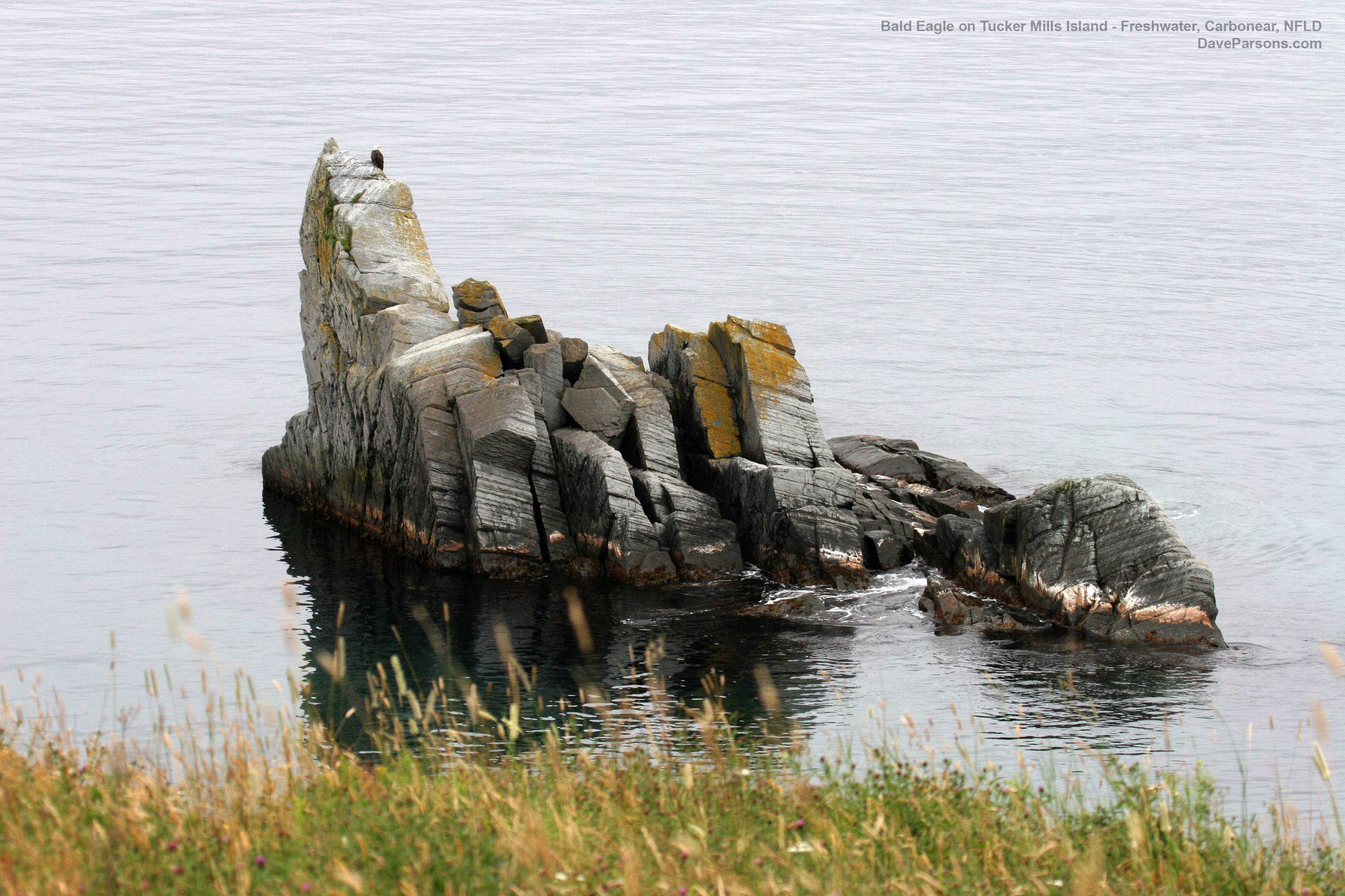
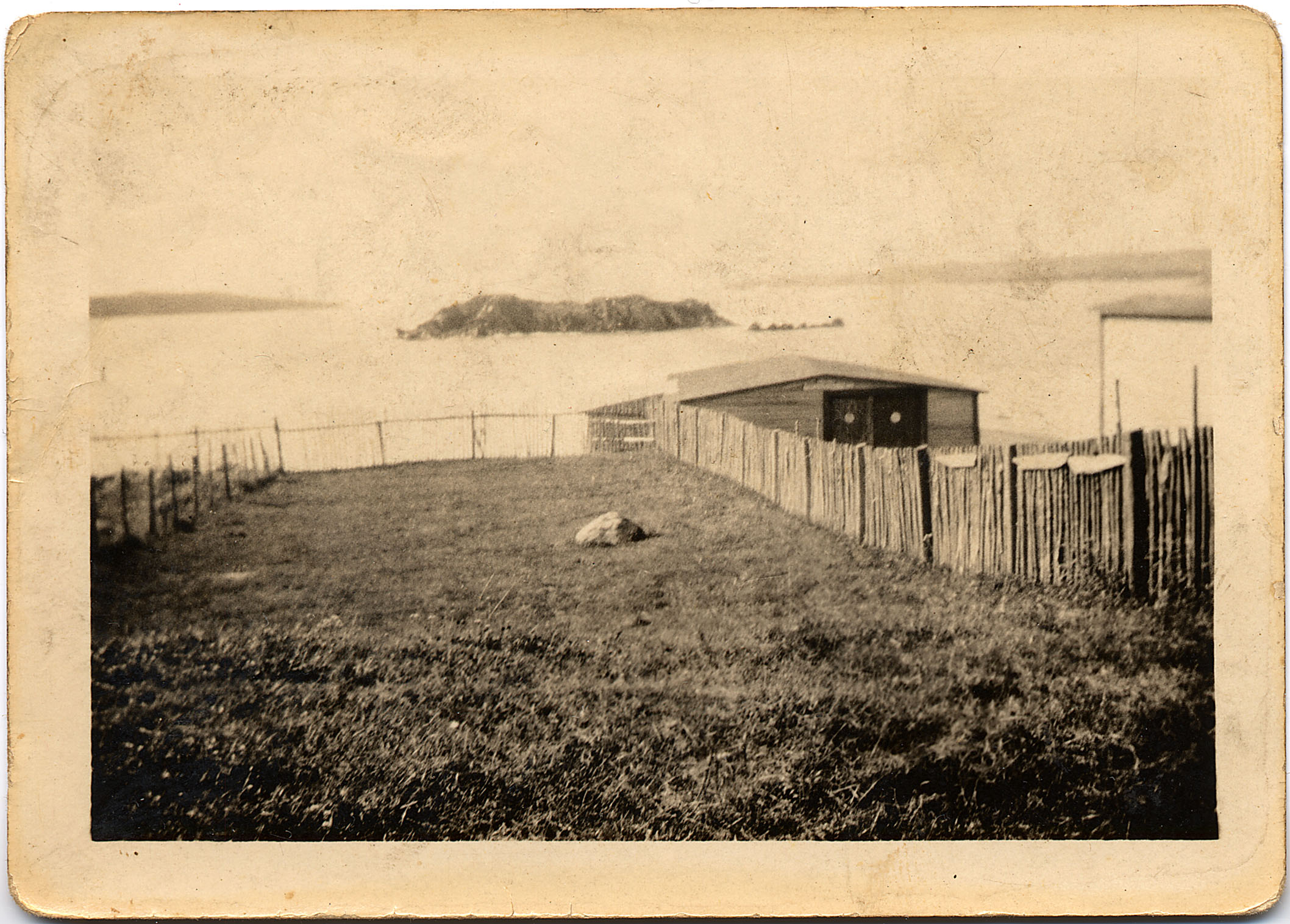
Locals refer to the jagged rocks just off Freshwater Cove as Tucker Mills Island, named after two young men who drowned while getting from their boat onto the rocks to hunt sea birds. In 2006, a bald eagle used it as a lookout while seagulls swooped low to haze the raptor. (Dave Parsons photos)
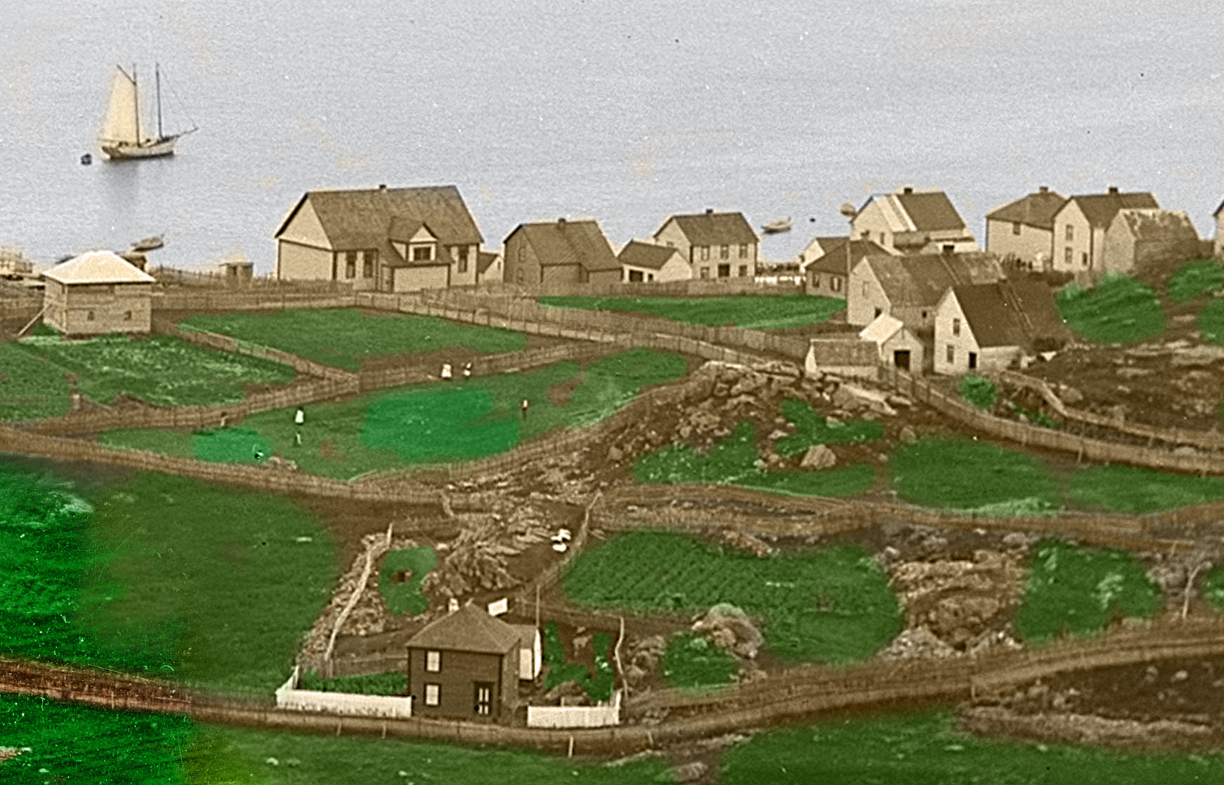
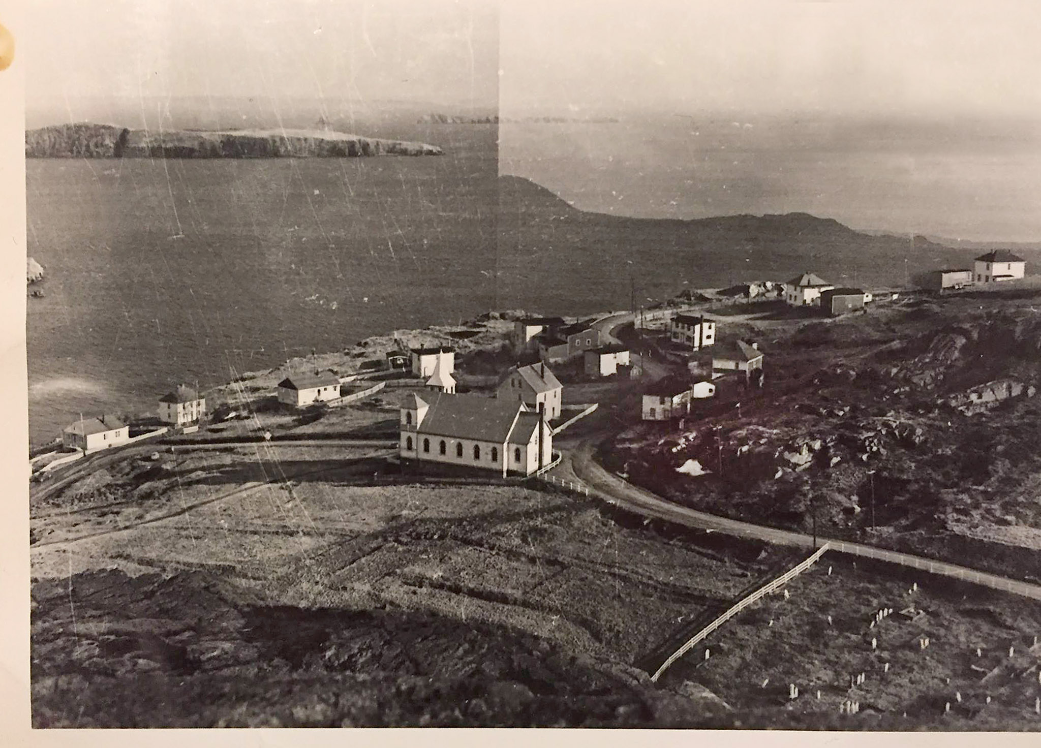
1900 and 2006 views of Clown's Cove, Conception Bay, Maiden Island, Carbonear Island and Freshwater. (Author's personal 2006 photo and black and white Robert Holloway (1850 - 1904) photos with added color and text from The Rooms Provincial Archives - photos B 4-76 & F29-19)
The Start of a Busy Fishing Village
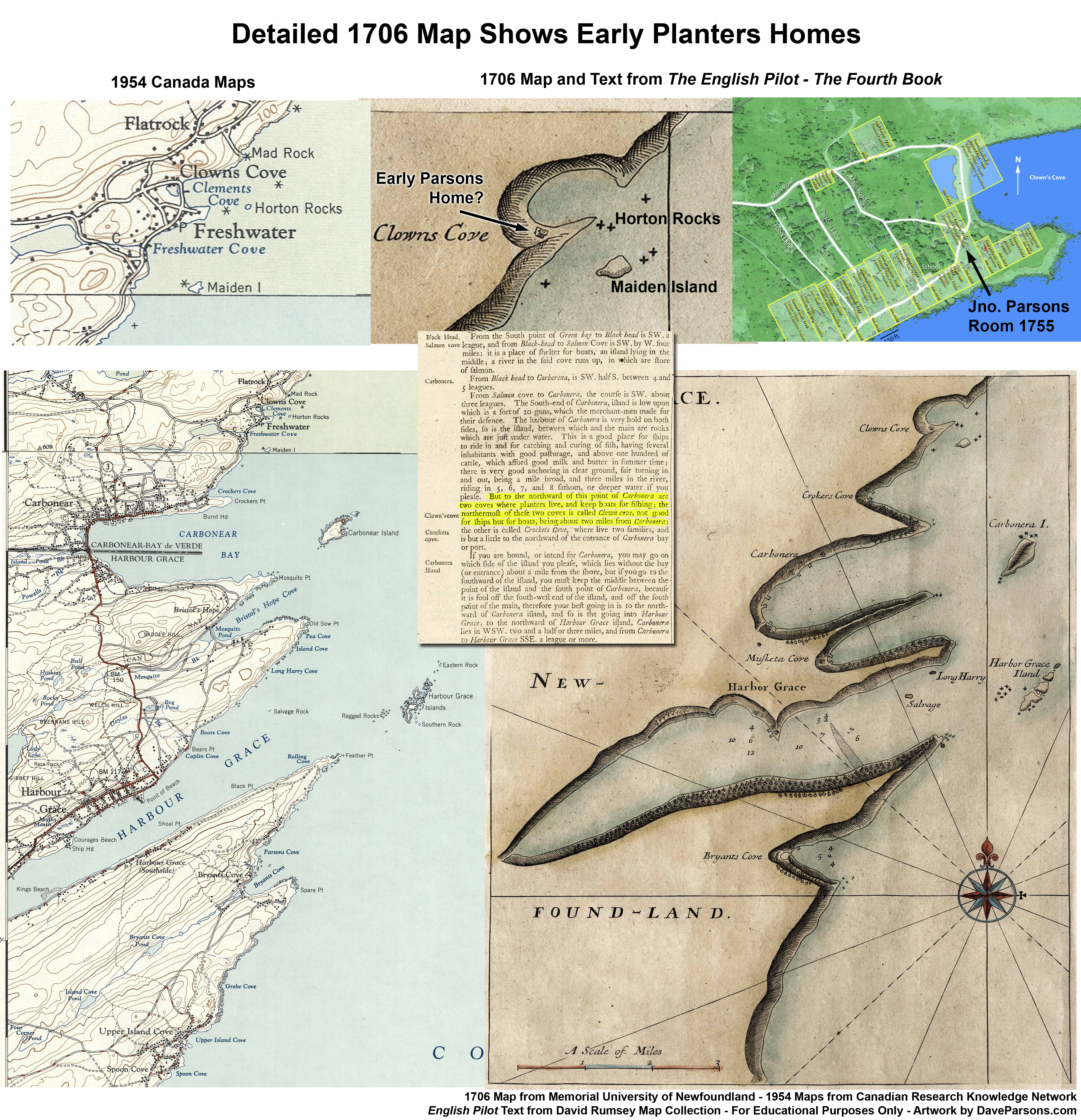
Located on east side of the Newfoundland Island on the Avalon Peninsula, Clown's Cove sits perched above the Conception Bay, looking out towards Maiden and Carbonear Islands. Standing tall behind dispersed homes and gardens with a few fishing boats, the glacially smoothed "Tolt Rocks," tall stone hills found throughout the island, provide a windblown overlook for Clown's Cove and Freshwater along the edge of the sea. Perched in the side of the hills, an odd face with large nose and chin looks westward towards Carbonear. As a result, early arrivals who found the cove favorable for landing their fishing boats, likely dubbed it "Clown's Cove" (See Graham Butt point out the face in the rocks in 2006). Many early maps, including one from 1675 and 1677 identify the location of the small cove. (Maps from Memorial University of Newfoundland)
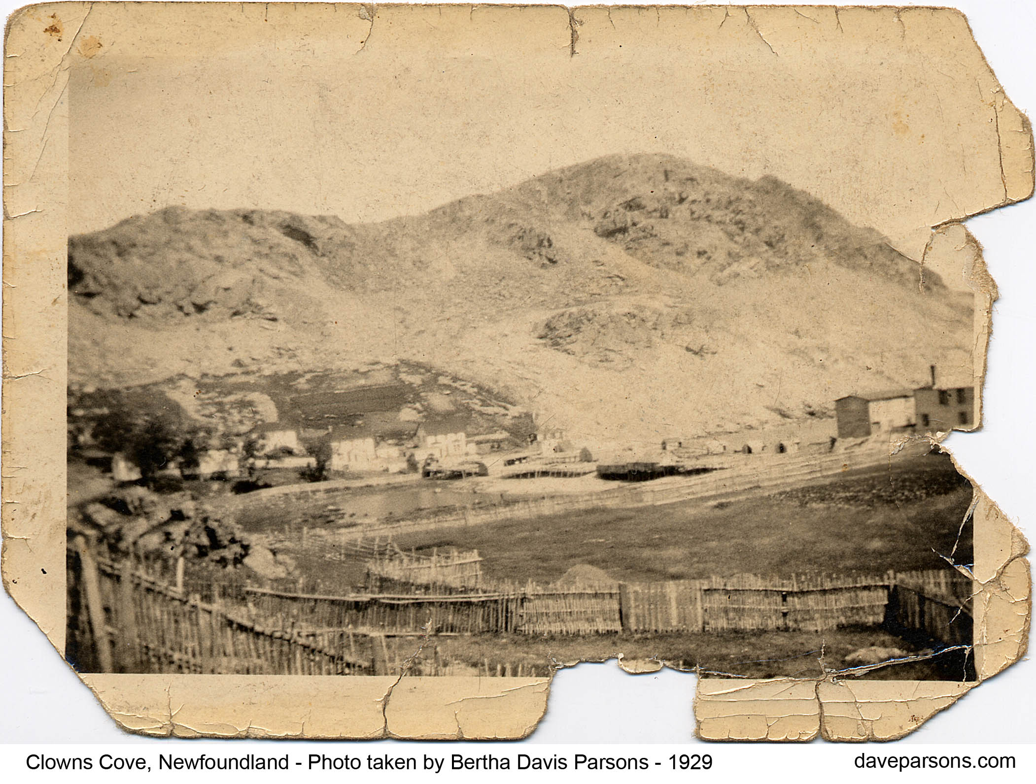
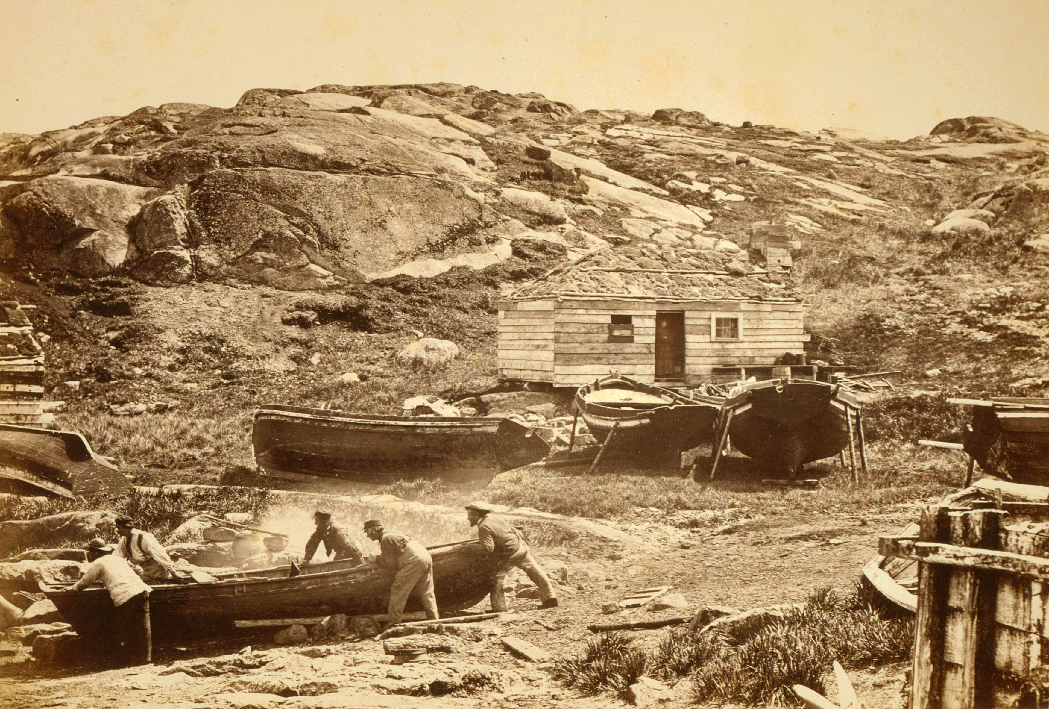
Taken by my great grandmother, Bertha Davis Parsons, the well worn 1929 photo above shows the "tolt rocks" overlooking the cove filled with stages, or wharves with sheds for cleaning, and salting cod fish. Fish were dried on flakes, or slatted frames and stored in sheds. Small breadbox shaped homes, also known as "saltboxes" to Newfoundlanders, stand among long fence lines of cut saplings outlining the property boundaries. Gardens cling to the hillside and stand in the open fenced field.
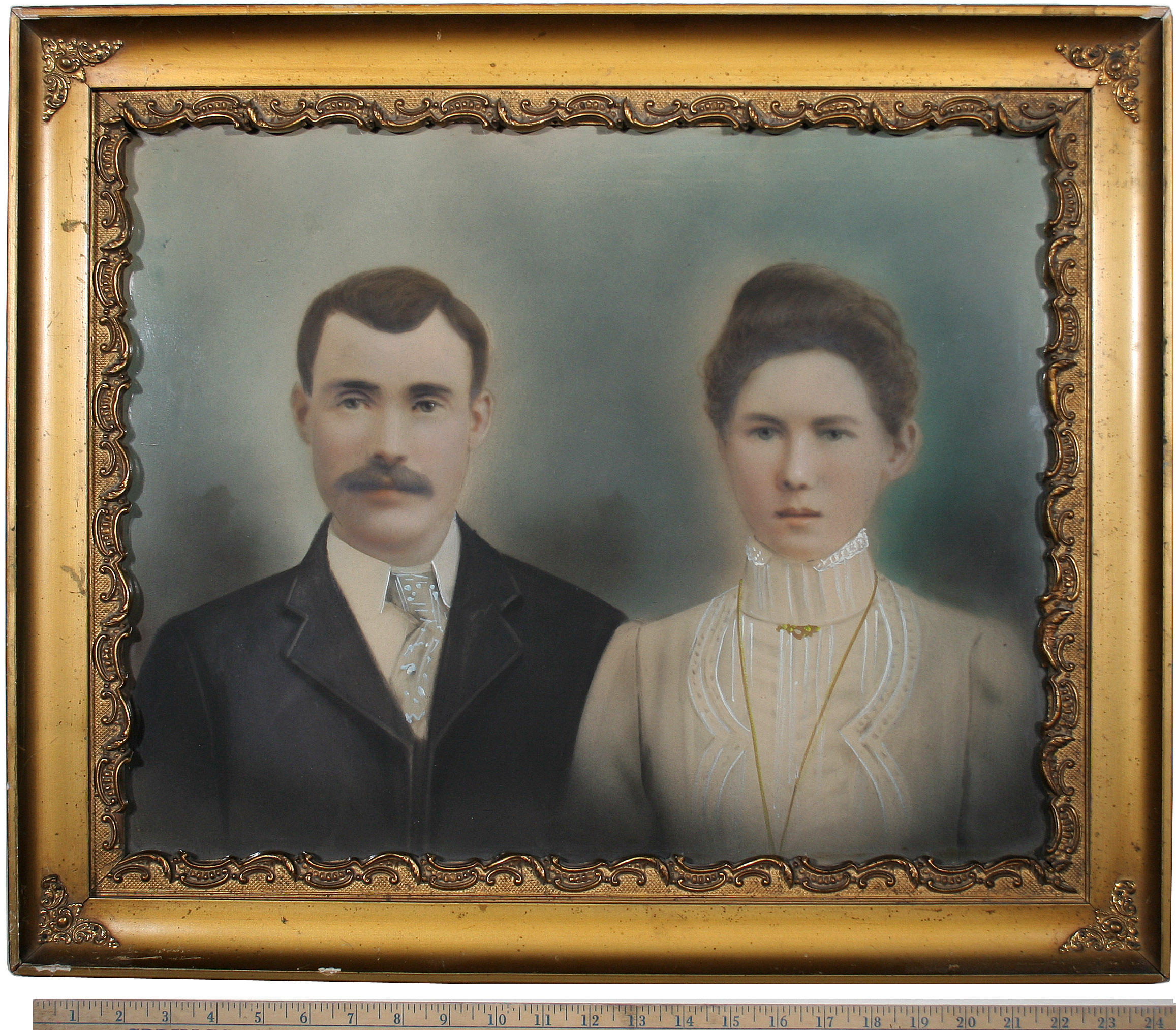
In a 1903 sun enlargement or "pastel photo," my great grandparents, James Parsons Sr., born 25 June, 1877 in Freshwater, Newfoundland stands next to his wife, Bertha Davis, who was born on 2 December 1878 to William Davis (1850 - 1937) and Jane Moores (1853-1919) in Freshwater, Newfoundland.
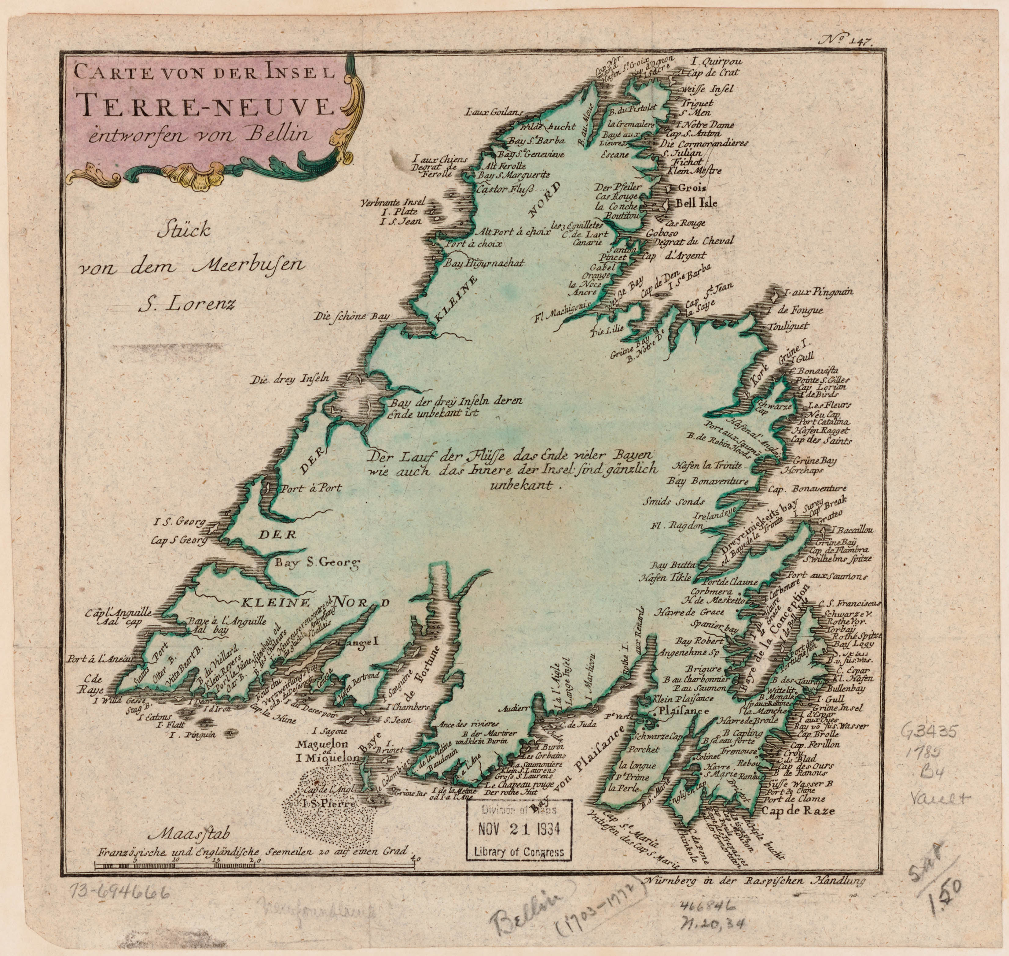
On a 1785 map, Clown's Cove is pointed out on the Avalon Peninsula. Click the map for a larger version and look for 'Port de Claune' next to 'Carbonera' or Carbonear. Map from Memorial University of Newfoundland
With south at the top rather than north, an early map of Newfoundland from 1625 by John Mason (in Sir William Vaughan's book "The Golden Fleece") shows Conception Bay and one of the earliest English colonies established in North America, the 1610 settlement of Cupids. The area had long been used by European countries sending their migratory fishing fleets including the English, taking advantage of the cod stocks since 1502. However, many of the earliest residents in towns along Conception Bay were populated from some of these early settlers from early colonies like Cupids. One of the Cupids settlers and governor, John Mason even tried to promote Newfoundland and Labrador as a potential home for Scottish migrants during the early 17th century, but was largely unsuccessful. Map from Folger Shakespeare Library and Memorial University of Newfoundland.
The last will and testament of Thomas Moores written on May 22, 1754 describing the Freshwater property or plantation he left to his family. (Families of Newfoundland). Moores tree from Bertha Davis. Familysearch.org
In the English fashion of "Planting" a colony, the English 1805 Plantation Records (717K PDF) indicate the Parsons had established a large property or plantation on Clown's Cove, located where the homes are on the right in the photo above. The fishing "room" or property dates before 1755 and was owned by a Jno., John Parsons or Johannes. The property was "By deed of gift from his Father." The Davis family owned an adjacent plot of land with the 1850 Eli Davis house. The majority of the homes, stages and even beach in Bertha's photo above were owned by the Pike family who are also listed in the 1805 records.
William, George and Eli and Bertha Davis family tree - Likely part of the same Davis line who eventually inherited Room #951 and later sold it John Parsons.
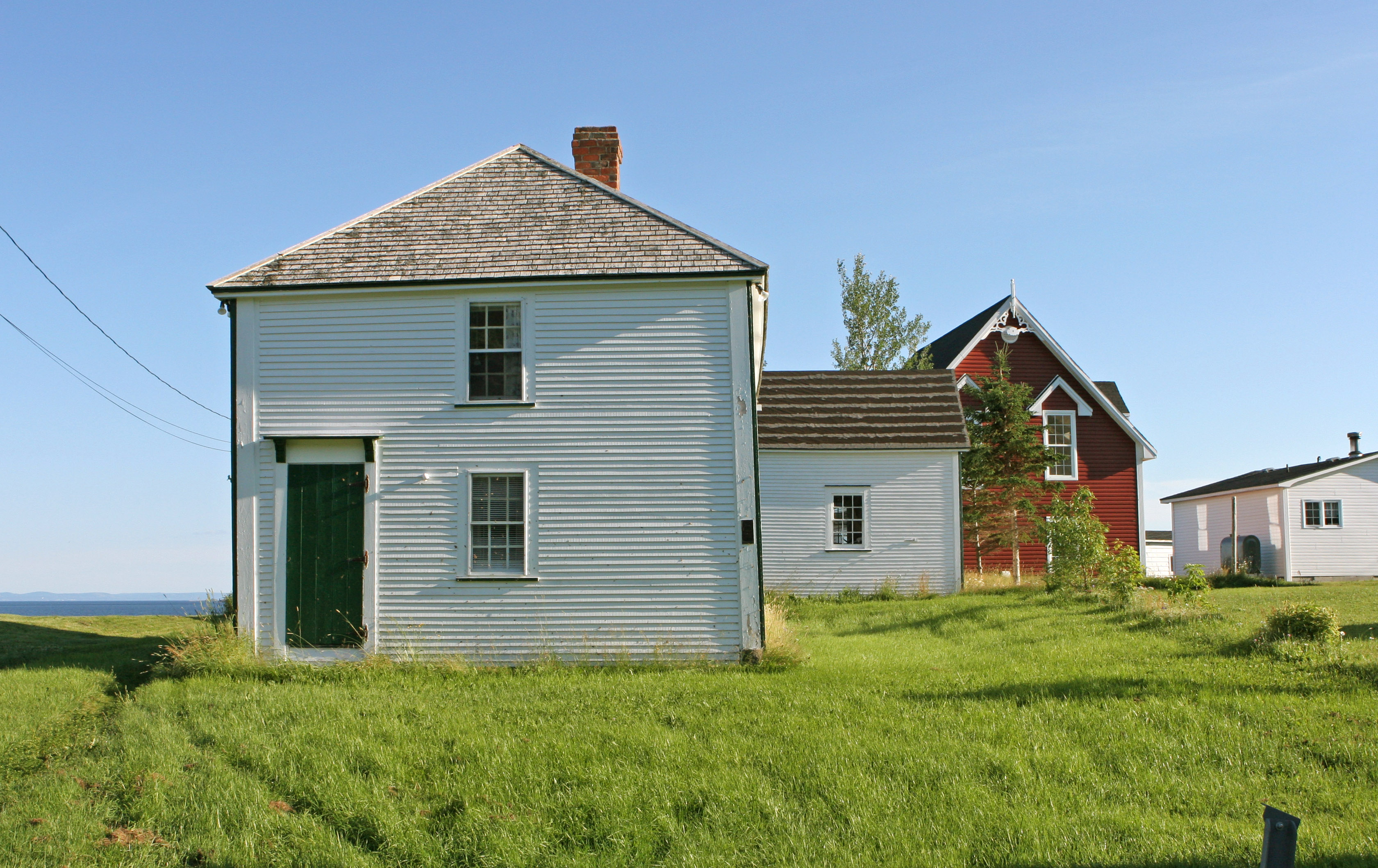
The 1850 built "Eli Davis home" still remains standing today (May have been built by his father, George). Eli was the son of George Davis and grandson of William Davis. The house sits on Room #951 with the Clown's Cove tolt rocks in the background. Photo taken in 2006 by the author.
Two early documents related to Clown's Cove Fishing Room #951 follow ownership as it passed through the generations and families. The first is a will from Jane Toque, giving her grandson, William Davis her third of the Clown's Cove plantation, (referred to as the Andrew Markin Plantation) located in between John Parsons and Thomas Pottle's plantations on November 10, 1774.
"Clowns Cove - November 10, 1774
Know all persons whom it may any said concern that I Jane Toque of Clowns Cove aforesaid relict (widower) of Peter Toque deceased do for divers good cause and consideration give unto my well beloved grandson William Davis all my third part of the room or plantation lying & situated in Clowns Cove..."
In the second document, George Davis, sells the room #951 in Clown's Cove Plantation to his neighbor, John Parsons in room #950 for 36 English pounds on November 24, 1807. The area is described in the document as "...all that room or Plantation situated in Clowns Cove in the aforesaid Newfoundland Island formerly in the occupation of the aforesaid George Davis and bounded on the West by a Plantation occupied by the aforesaid John Parsons & in the East by a Plantations occupied by Thomas Pottle together with all the Premises Houses out houses, Flakes, Stages etc. appertaining thereto with all ways, paths, passages…"
Document and Tocque family research from Pete Noel (2023, Vol 39, 4. "The Ancestor" fhsnl.ca) and Newfoundland Genealogist, Susan Snelgrove - Thank you! Documents from Family History Society of Newfoundland and Labrador - fhsnl.ca.
A closer and cropped view of rooms 950, 951 and 952.
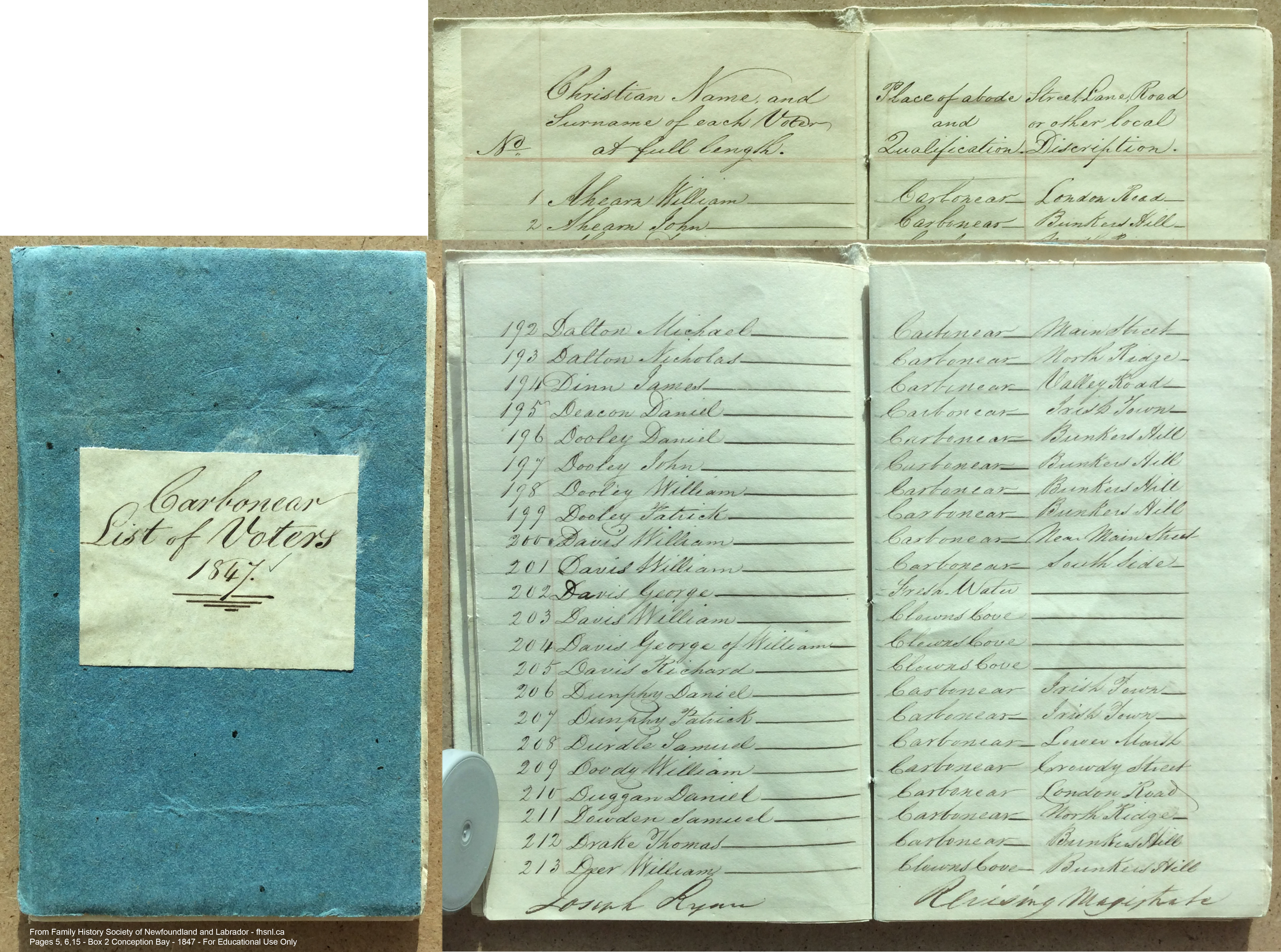
1832 and 1847 Voters Lists for the Parsons and Davis of Freshwater and Clown's Cove. Documents from Family History Society of Newfoundland and Labrador - fhsnl.ca.
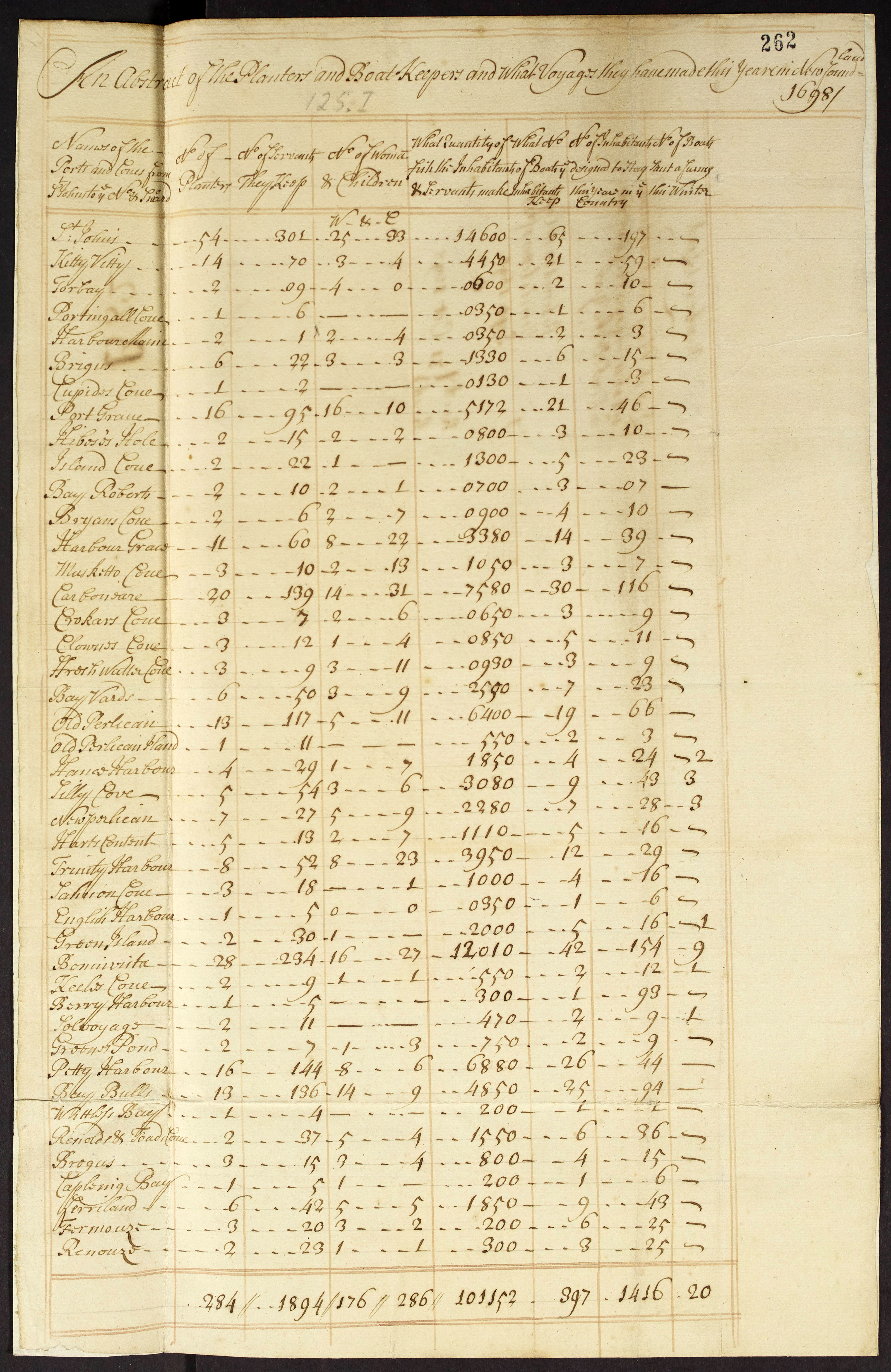
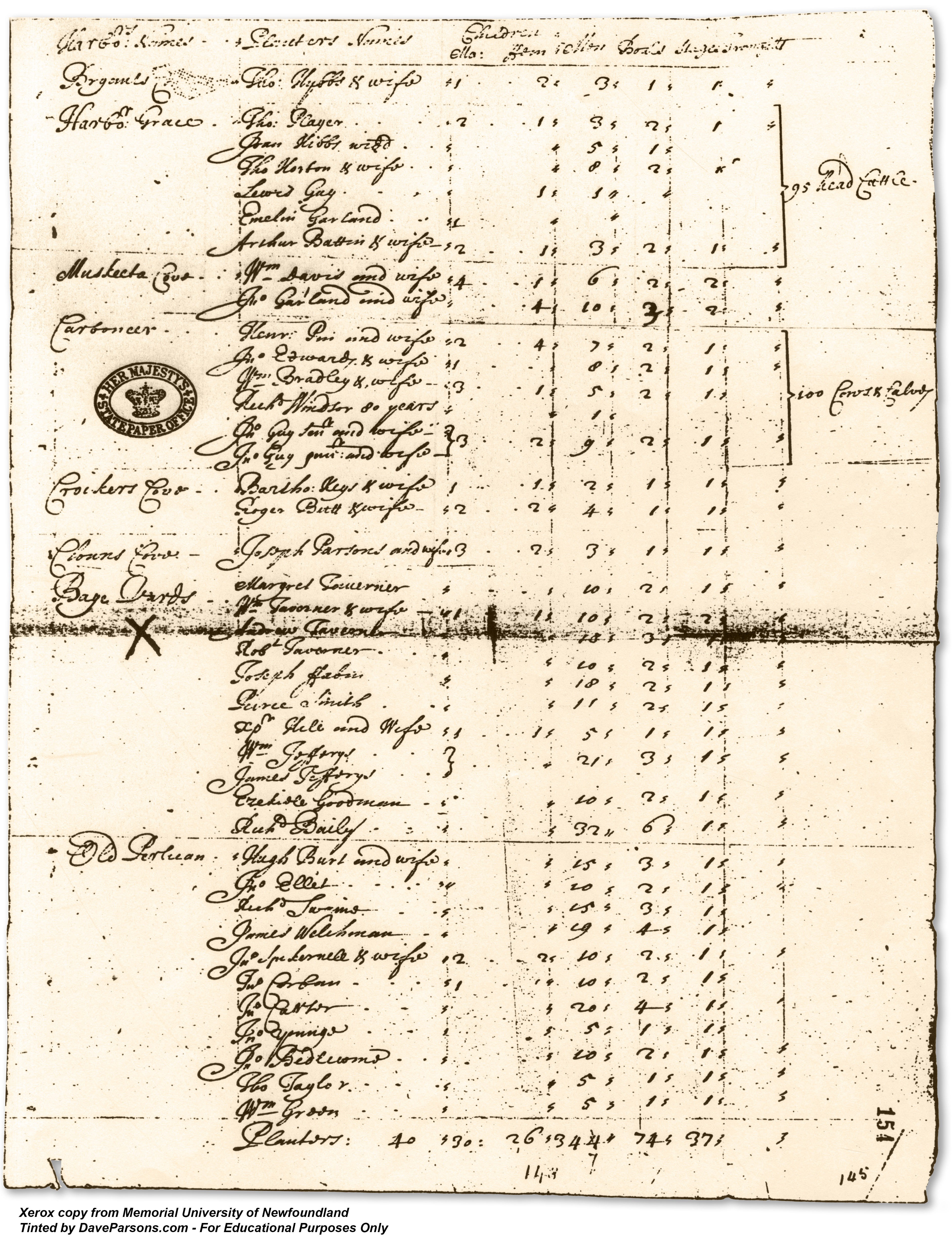
A 1698 accounting shows Clown's Cove with 3 planters, 12 servants, 1 woman, 4 children, 850 qunitals of fish produced, 5 boats and with 11 inhabitans that remained in the 1698 year. It also lists many of the surrounding towns of Crockers Cove, Carbonear, Harbor Grace etc.
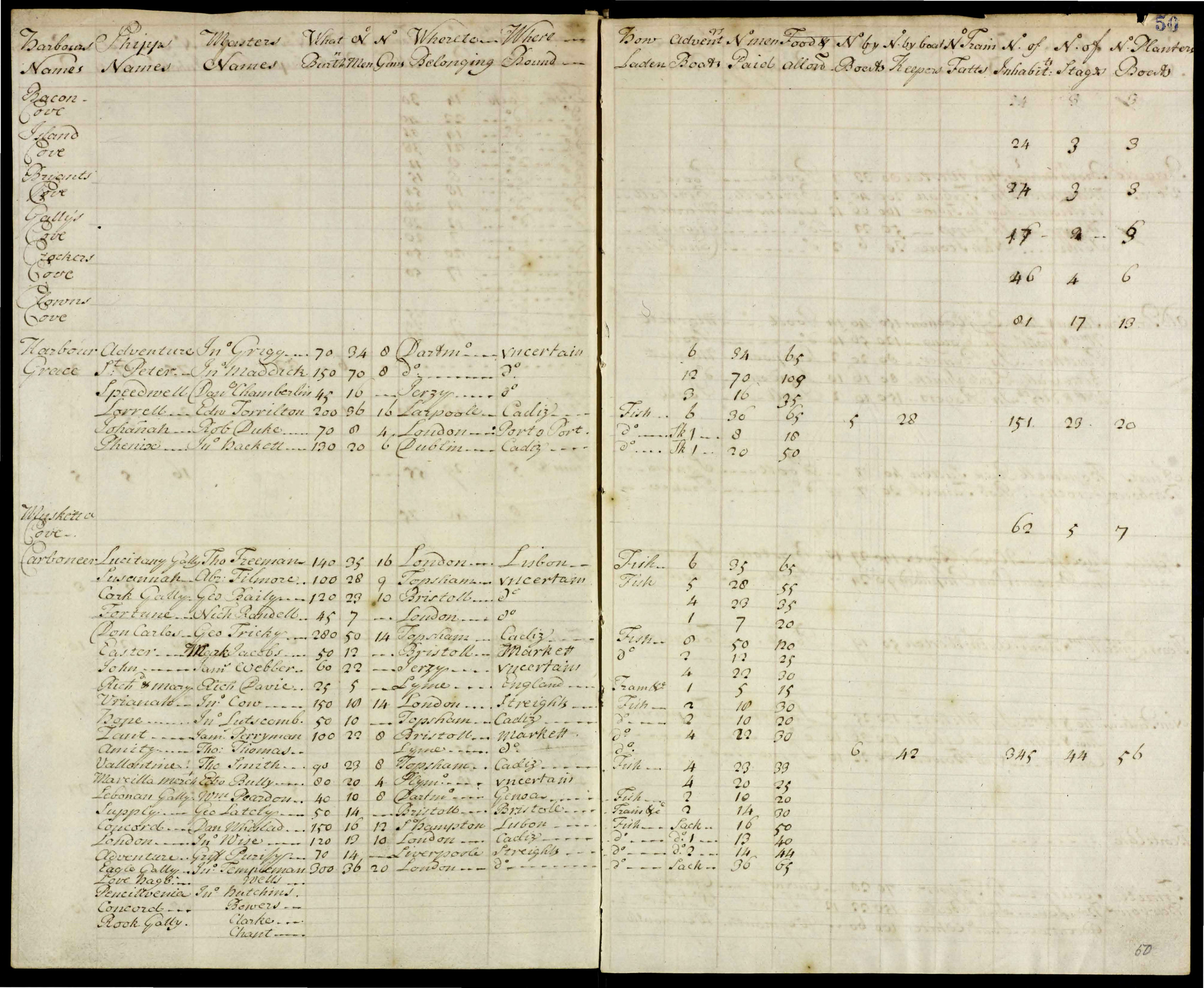
A couple of years later, more people were living in Clown's Cove. According to an account of the fishery in 1700 by Captain Stafford Fairborne, Clown's Cove now had 81 inhabitants with 17 stages and 13 planters boats. Nearby Crockers Cove had 46 inhabitants, 4 stages and 6 planters boats. His report details that planters made a living "by catching of Fish, then Splitted, Salted, washed, and laid of Flakes to dry, which will be a month before thoroughly cured, Their employment by winter is, Sawing Trees to make Boats for building Shallops, & Some goe (sic) a Turring (Hunting birds)." He also wrote "I have found that some of ye Inhabitants, Since the year 1685, have engrossed Some Stages, Cook Rooms, Beeches (sic) & other places, which before that time belonged to Fishing Ships; but upon ye arrival, they have relinquished ye Same, to ye publick (sic) use of ye Fishing Ships, arriving there."
A 1708
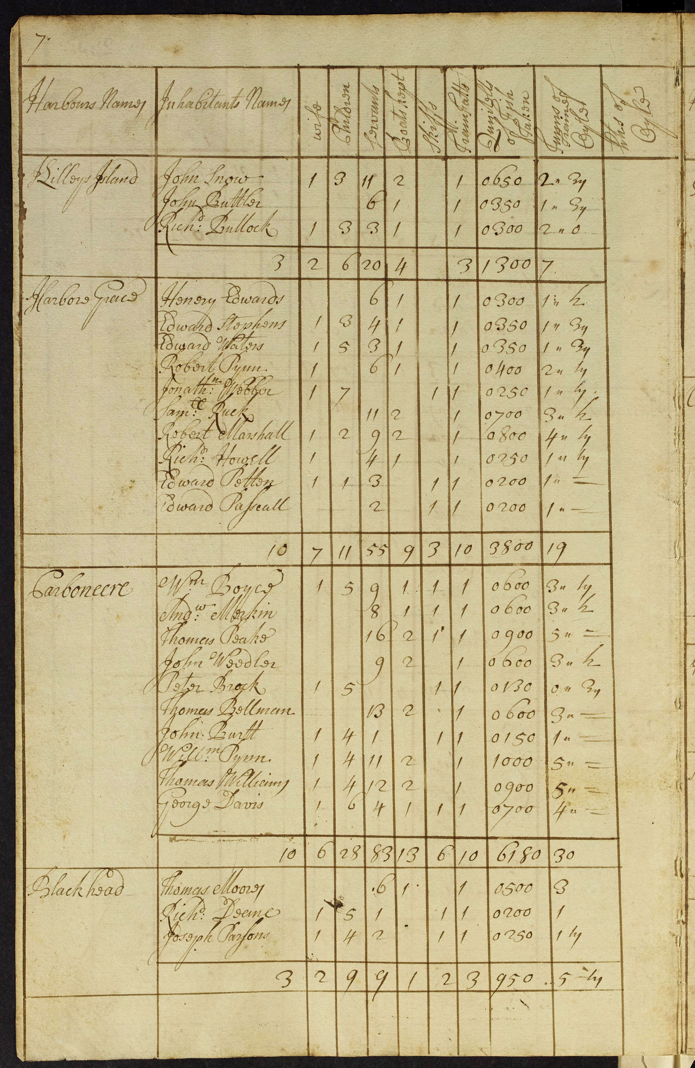
account names Joseph Parsons (likely the same listed in the 1675 census) and Thomas Moores at Blackhead, a tiny area a couple miles north of Clown's Cove. It also lists the merchant, Geroge Davis in Carbonear.
Another view of the Eli Davis House on July 20, 2006. (Dave Parsons photo)
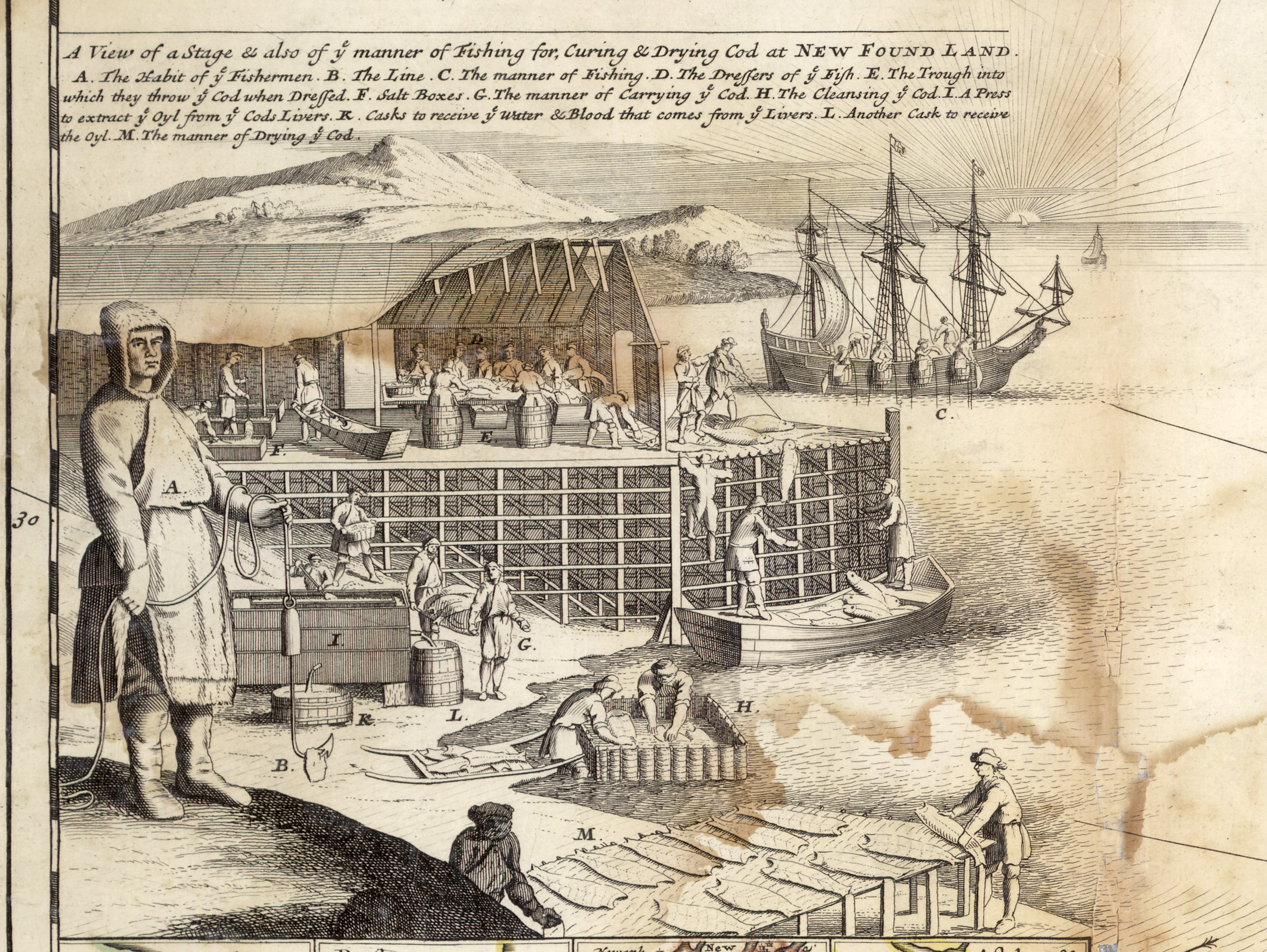
Showing the preparation of fish, a portion of a 1709 North American map demonstrates the process of curing cod with a migratory crew of fishermen complete with early ships. In Freshwater and Clown's Cove, families would be performing these same duties. From Memorial University of Newfoundland
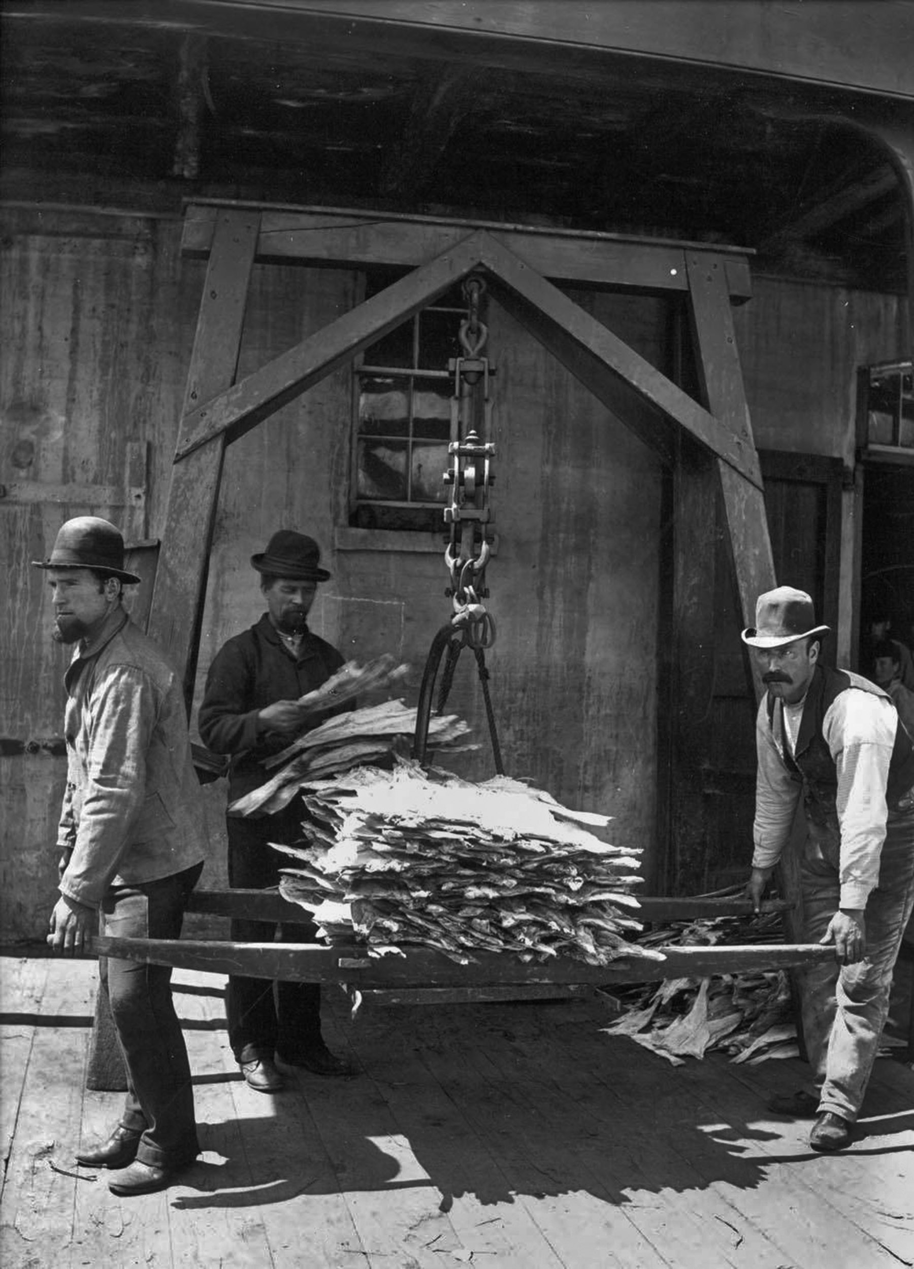
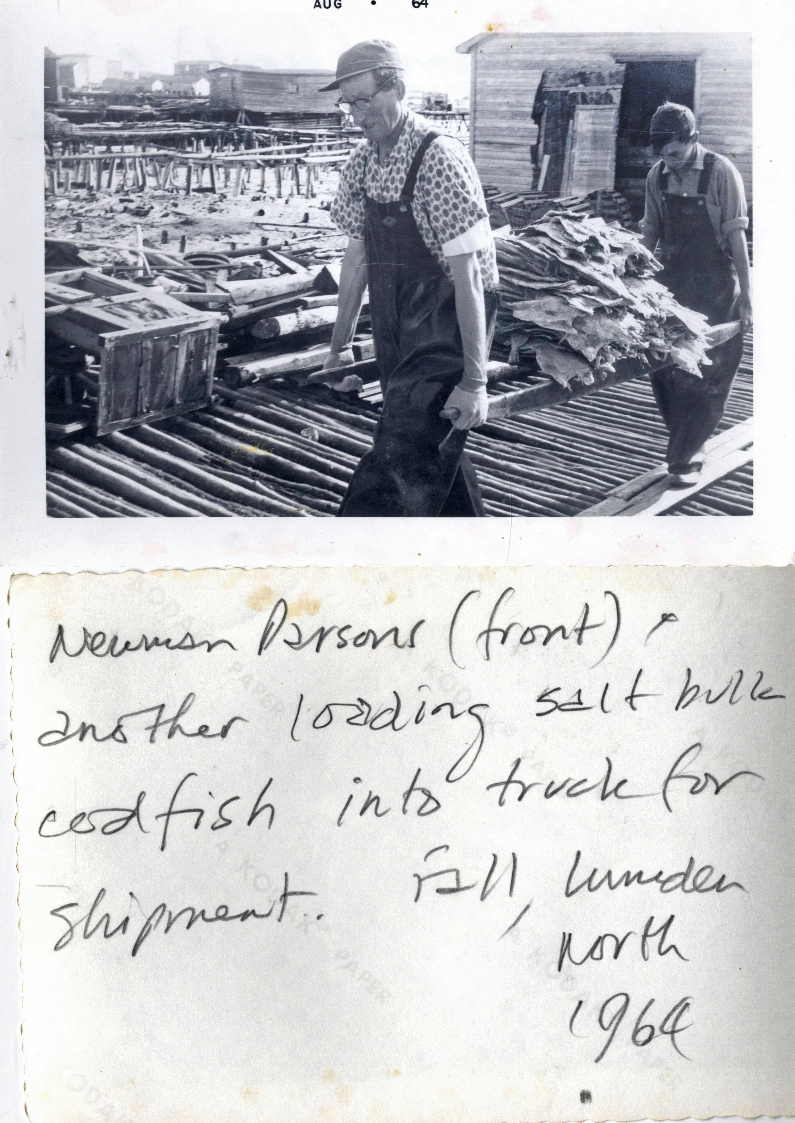
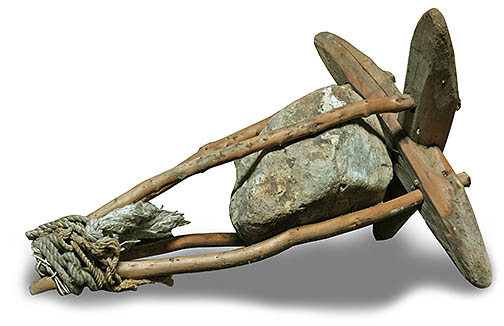
Looking like a sled, a wooden fish carrier illustrated in the 1709 map above (just below L.), is the same as the 1880s photo of weighing fish at Tessier's warehouse, as is the James Faris photo taken in 1964. The technology for carrying fish never changed for well over 250 years of use. The carrier above was photographed at the Carbonear Heritage Museum in 2025 (Dave Parsons photo). Photos from Memorial University of Newfoundland
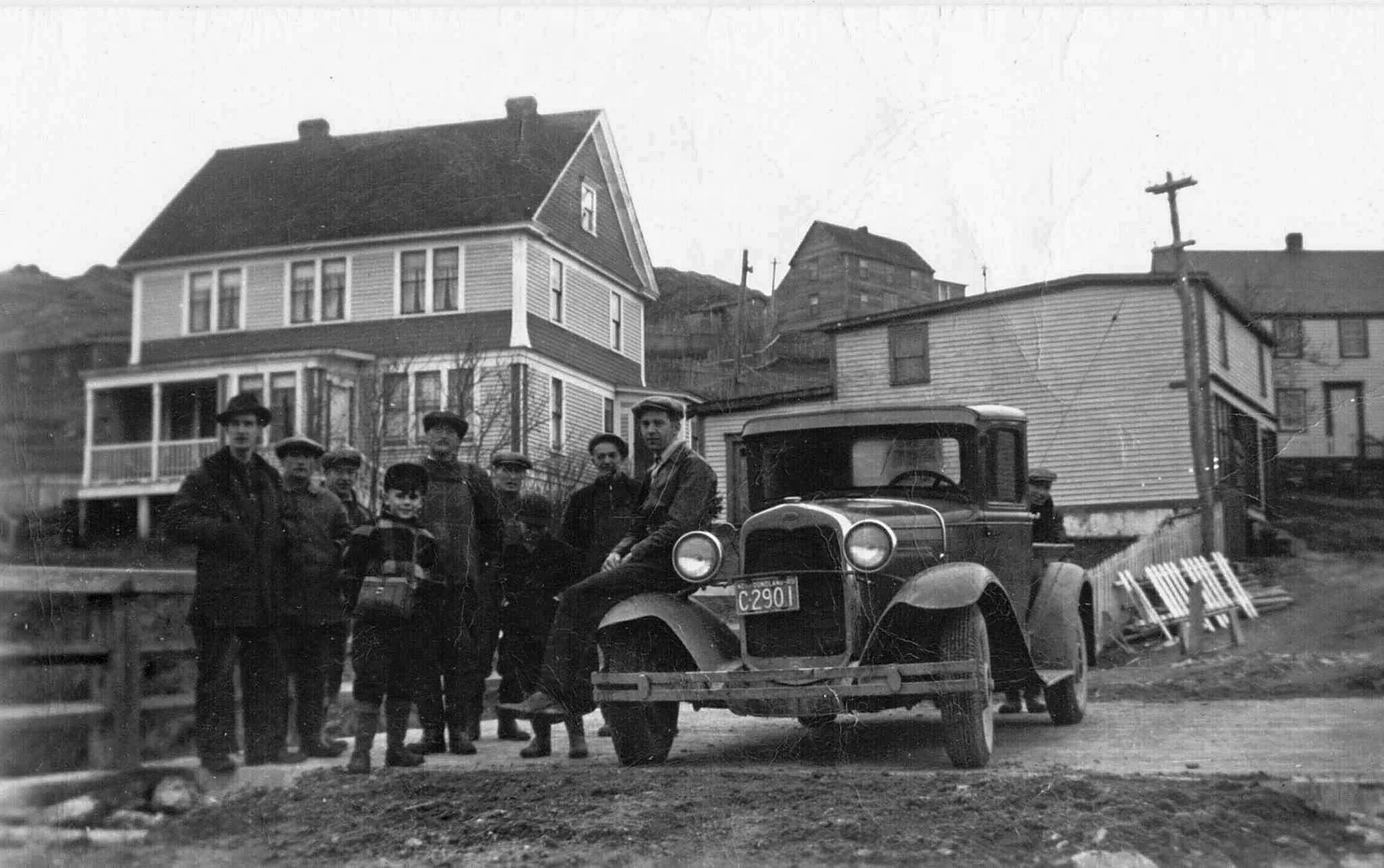
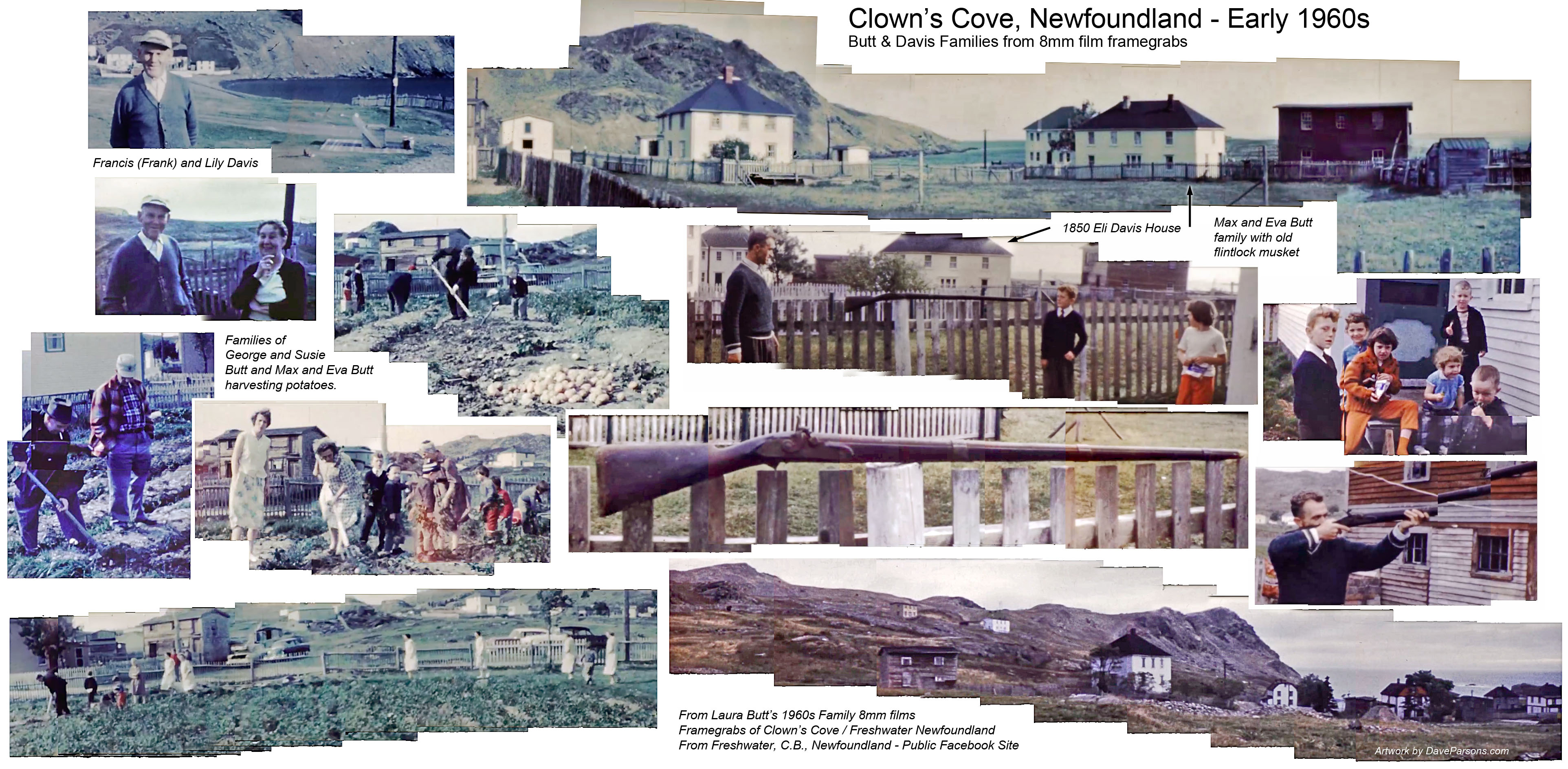
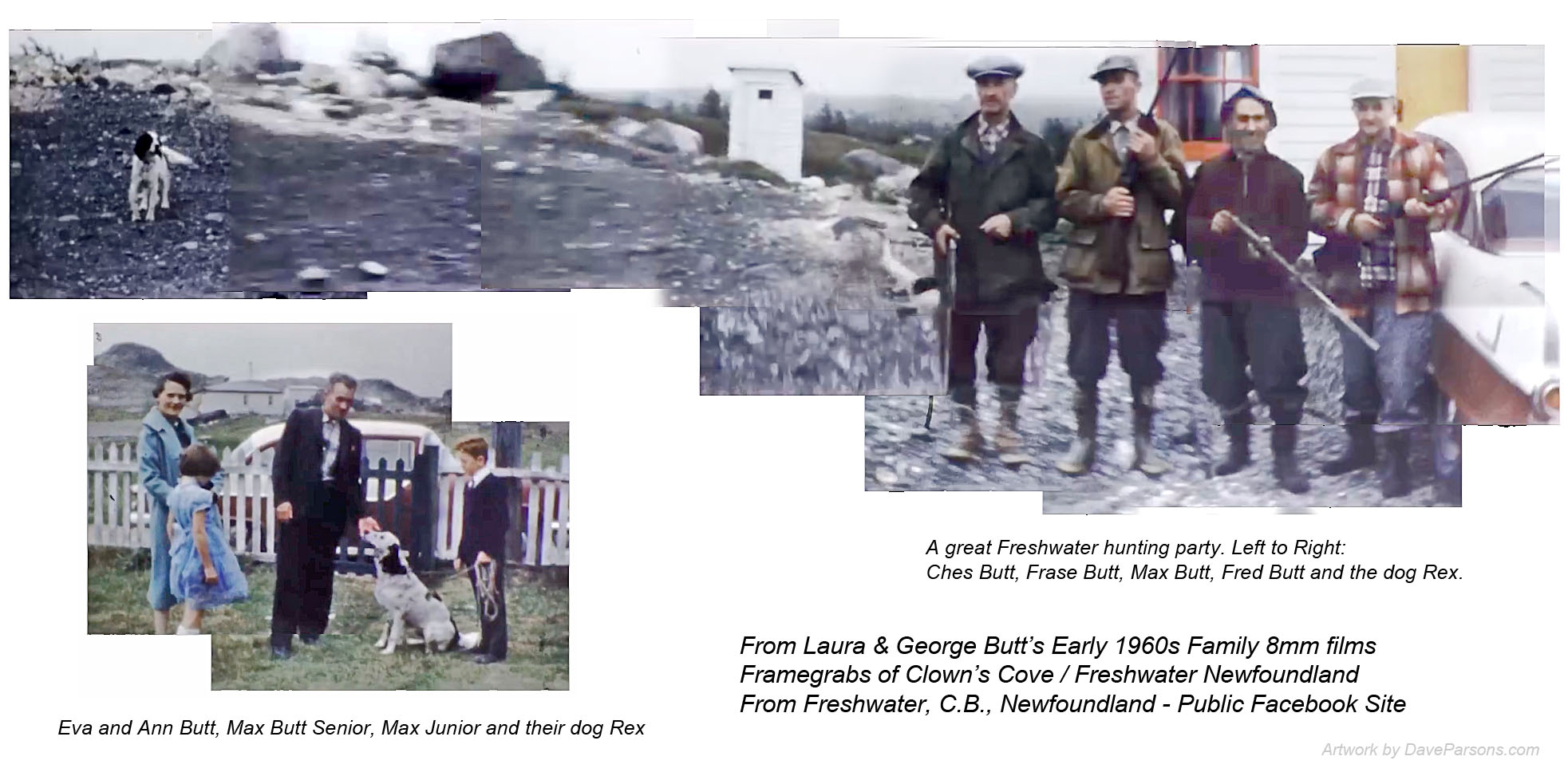
With a nearly deserted beach in 1955, Clown's Cove was home to just a few boats, telephone poles and a couple of small sheds. The Pike home stood at the bottom of the photo with the homes of William Frazier Butt (far left), George P. Davis, Frank Davis and John Hayward Davis (Eli Davis Home) out on Clown's Cove Head. Parsons family homes, descendants from John Parsons stood just off Clements Road adjacent to the Eli Davis home. (Photo from Public Facebook group - Freshwater, C.B., Newfoundland)
Just to the west of the Parsons room were a trio of rooms belonging to another family of early arrivals, the Moores. According to the last will and testament of Thomas Moores written on May 22, 1754 he left "unto my Son John Moores All that my Freshwater Plantation" in Conception Bay. Room 948 is listed under a Jno. or John Moores whose room also encompasses the home location of my great, great grandparents William Davis and Jane Moores Davis, one of the many great, great grand daughters of Thomas.
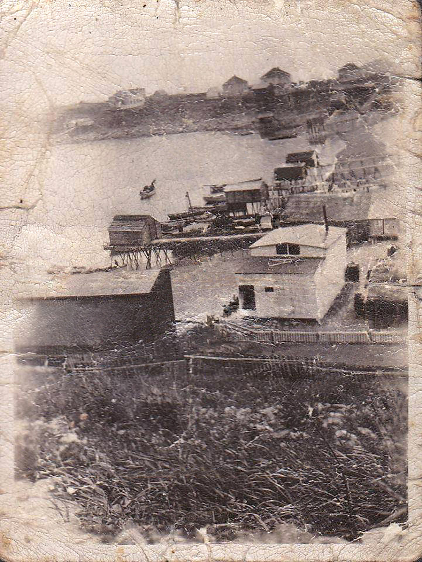
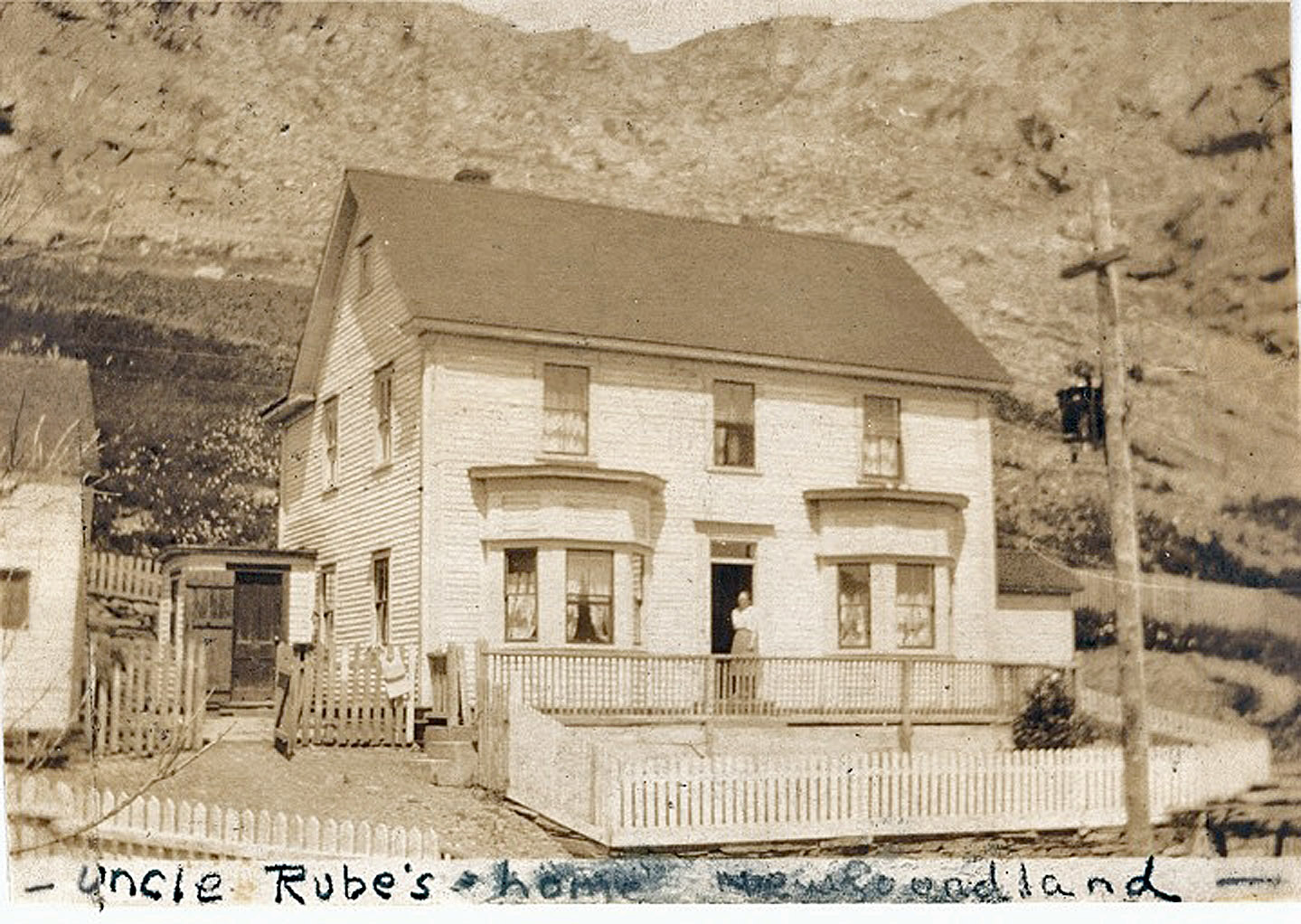
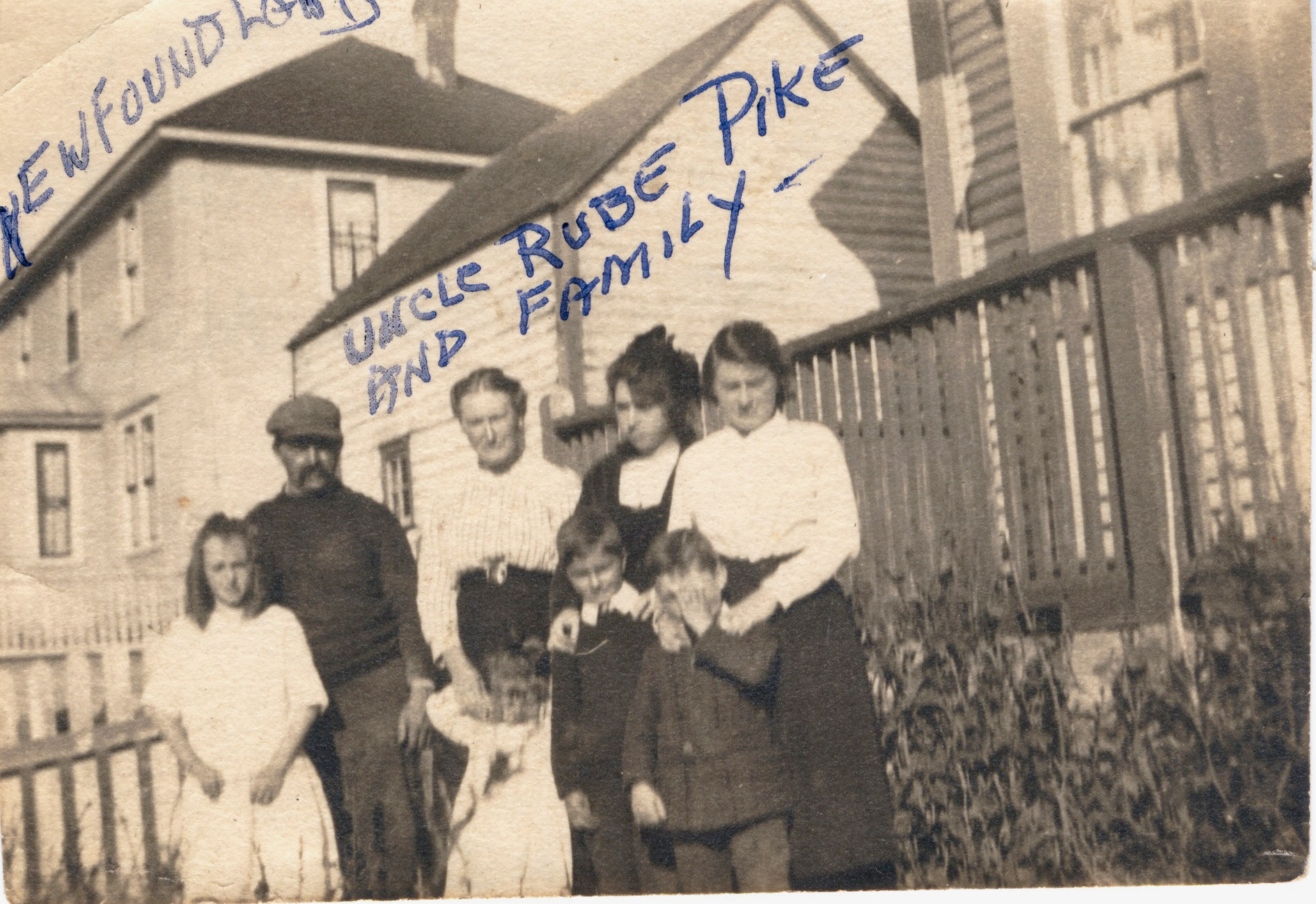
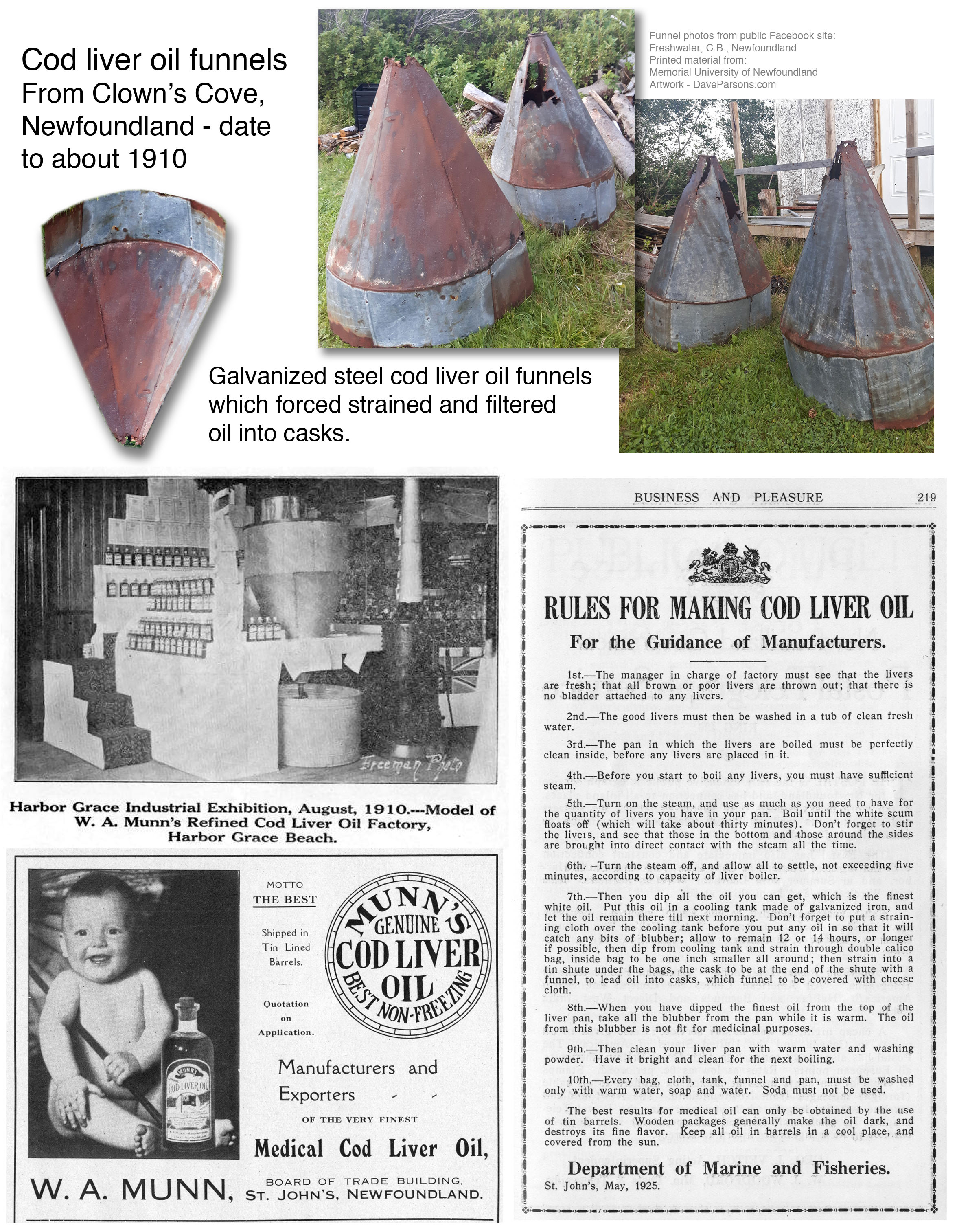
Clown's Cove was a busy cod fish processing area into the 1920's. Photographed about 1919, the well worn photo above shows stages and storage buildings taking up most of the cove beach. According to longtime resident Herman Butt in his 2011 poem, "The Merchants of Freshwater," Reuben and Jake Parsons owned a cod liver oil factory on the beach, yet others suggest the white building in the lower right could be the Pike family cod liver oil factory (Perhaps Herman was writing of Rueben PIKE and Jake Parsons?). Nevertheless, by the 1930s and the Depression Era, most of the structures would be gone from the cove. Today, a beach and breakwater are all that remain except for a couple of early 1910 galvanized steel cod liver oil funnels in the yard of a Freshwater resident (sadly disposed of in 2018). (Clown's cove photo and funnel photo from Public Facebook group - Freshwater, C.B., Newfoundland)
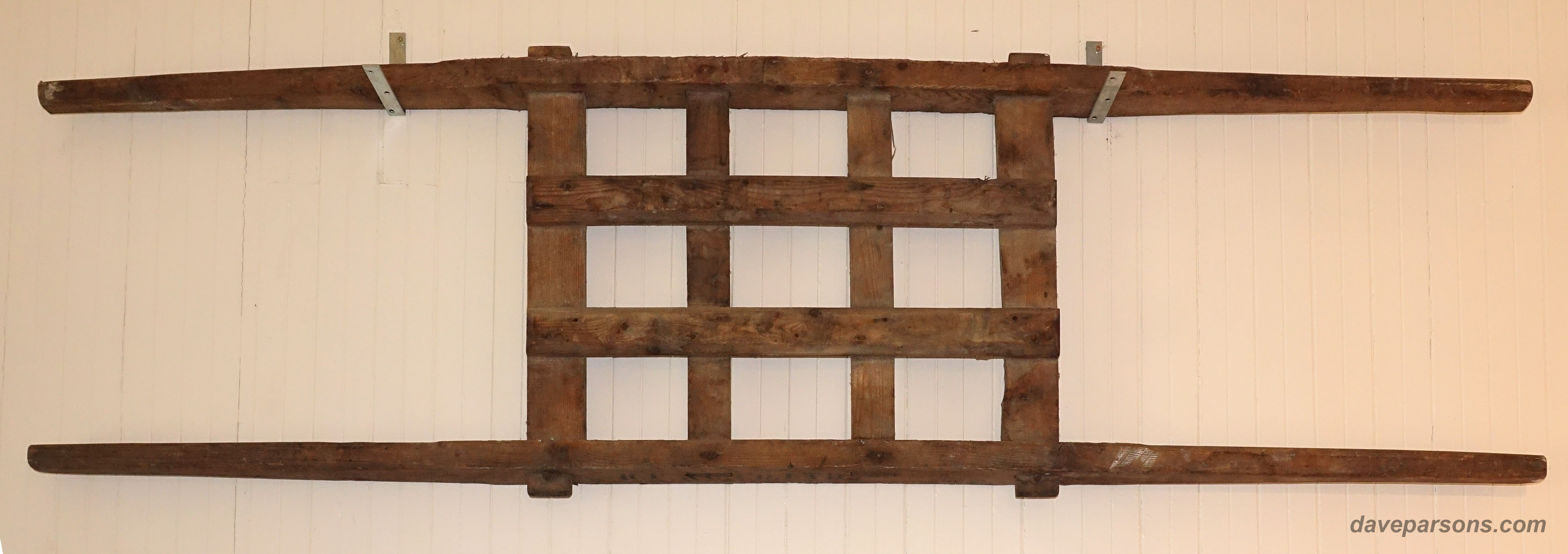
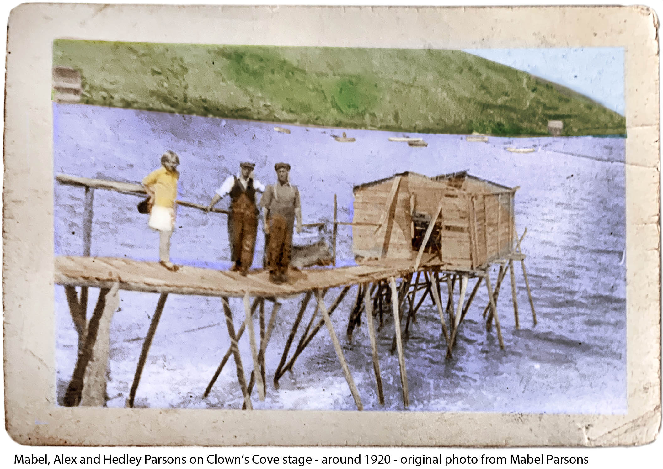
Mabel, Alex and Hedley Parsons, stand on a surprisingly durable, Clown's Cove stage about 1920. Stages were wharves with sheds used for cleaning, splitting, salting and storing fish and descended off rocky headlands to a sufficient water depth to unload a skiff or fishing boat. (To make the stage stand out a bit more, I tinted or colorized the original photo in Photoshop) Photo courtesy of Mabel Parsons and Bert Parsons.
Clown's Cove would have had an overpowering smell of fish, salt and seaweed. Spidery stages built from spruce poles and slats would hang off the rocky coast lines, enduring crashing serf and roaring gales. Trees would have been almost nonexistent in the area, as migrant fisherman and later inshore fishermen had denuded the area since the mid 1500s cutting the black spruce and fir trees for fish drying stages and flakes as well as for ship repairs and later, homes and fences.
Families lined at stage tables would split, gut, deftly remove the spine and heads and salt the cod fish as fishermen tossed their catch from a bouncing boat towards the stage with single-tined forks which they called "pews." Livers would be tossed into an odious cask for cod liver oil. Voices would travel across the cove as stories, told in a "r-less" dialect inherited from English ancestors in rural shires would pass rapidly between workers (The accent probably spread to New England and especially the Boston area from Newfoundlanders migrating to the U.S. - just listen to anyone born and raised in Boston - "Pahk the cah in Havahd Yahd").
Salted fish would cure in sheds and eventually be washed and dried on flakes or drying racks or pine boughs in the sun and breeze. The fish would be turned twice a day for about a week and rushed to cover if rain threatened. Cod would be stored and consumed or if there was a surplus, weighed and sold to the village supply merchant, packaged in barrels and shipped off to Europe, the U.S. and South America.
When cod were "running plenty" fishermen would work night and day as children would gather the wild blue berries from the hill sides. "Time is fish and fish is money" was once a common saying for Newfoundlanders. Wool-sweatered fisherman in bulky oilskins and boots would ply the coastal waters in dories, skiffs and four and five man long liners, hand-jigging for cod or haul in gill and trap nets from dark waters below.
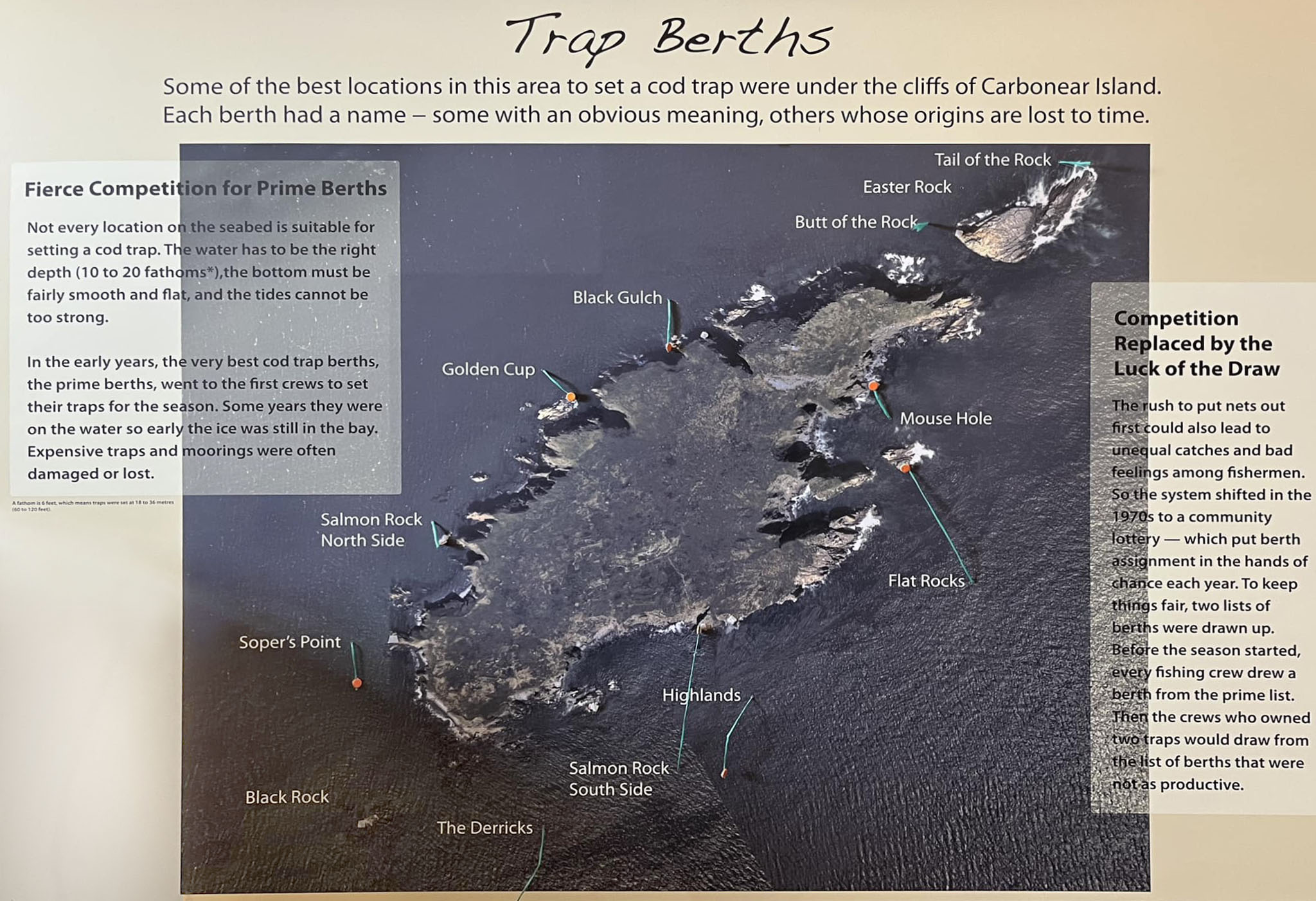
In a humorous and descriptive account from his book, "From the Nart Shore" of a 1915 inshore fishing excursion, longtime Flatrock resident and author, Herbert L. Pottle explains the competitive and delicate intricacies of "trap berths," fishing and loading, or in his case, overloading a boat in the waters near Carbonear Island:
"Shore fishing was invariable a short season - a few frantic weeks. It was when I was about eight years old that the date for setting cod traps was changed from 25 May to 5 June. Father used to figure 100 quintals of fish by 12 July (Orangeman’s Day) as a fair catch up to that date. A total "voyage" of 100 quintals per man was considered "a good summer". And a quintal of fish for a barrel of flour was a local equation signifying rough justice.
Getting on the water to catch the fish, and being able to cure it once ashore, were vital items in our current account…
My father’s crew as I have said, were four men in a boat…
Securing trap berths was something of a lottery but mostly a loss of sleep, especially in the case of very good berths. What usually happened was that the more powerful crews tended to make a pitch for the choice fishing locations around Carbonear Island well ahead of the trap-setting day - sometimes as much as a week in advance. This meant "lying to" on the berths during the day - anchored as a rule, which was against the law - and huddling up in some inlet of the island at night. Being thus exposed in an open boat for several days and nights, even by shifts, in late May and early June, was an outdoor exercise tantamount to an ordeal.
The "inside" berths - that is, the ones nearer the shore - were not so competitive, since most of them had been taken by the same crew year after year, so that they became known, for example, as John Charles Everly’s berth (Mad Rock), George Marshall’s (Peter’s Finger), or Ned Pike’s (Bradley’s Rock). The rest were more or less up for grabs. In order to make sure of one of the best of these one year, father was delegated to go after it, while the older brothers were in major action at the high part of Easter Rock, Carbonear Island. It was Sunday night, after church, when my church-going father and I pushed out punt off Broad Cove beach. Apparently he had reckoned that the better the day the better the deed. We held the berth overnight with part of a "fleet" of gear - that is, part of a complete set of anchors, buoys, moorings - father "keeping up" (keeping the punt on the berth, sculling into the wind), and I bailing water.
Some of the best fishing spots or cod trap berths around Carbonear Island. A fathom is six feet. (Photo from Public Facebook groups - Freshwater, C.B., Newfoundland)
Our larger cod trap was about 60 fathoms "on the round" (the total length of the four sides, the perimeter) and about 12 fathoms deep. The fish are led into the trap by a "leader" - a straight wall of twine - in such a way that, once the fish are inside, they tend to swim around and around in the same free space. The trap is winched or manually pulled from the bottom by four ropes, and as the twine is drawn up out of the water it is "paid away" (let go again), so that the area of the trap in which the fish are swimming is reduced until they are "dried up" at the surface. In the case of a big haul, once the boat is loaded, the rest of the fish are "bagged off" - that is, they are shifted from the trap into a large knitted, twine bag, then tied to the main trap and let float there until later picked up."
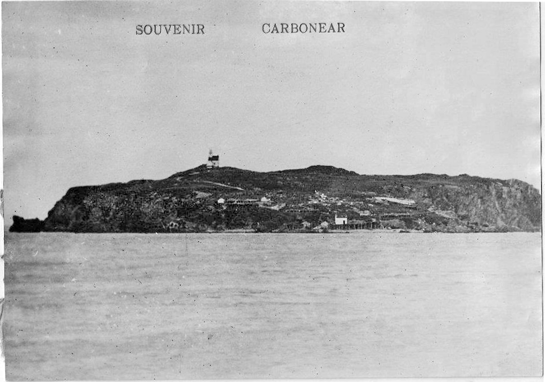
Carbonear Island postcard taken about 1900 with the lighthouse on the high point. Two summer dwellings with multiple stages stand just below and at the waters edge, a wharf with storage shed.
According to a longtime Carbonear resident "That old lighthouse served well, it's storm windows were put on our house in the winter & in use until the 1970's!, Taylor's of B/Hope grazed their sheep over there for years, Harry & his brother Pearce tended to the automated lighthouse until they retired & their sons Harry & Nelson took over, along with Hr. Grace island & the beach at Hr. Grace." (Photos from Public Facebook groups - Freshwater, C.B., Newfoundland)
After a particularly good haul, no one in their crew wanted to say "when" to stop taking fish aboard. As a result:
"Down, down settled the boat, inch by inch, quintal by quintal, fish by fish, until the water was lapping the gunwales. Probably some warning word from father or Art that we were going under stayed the overloading hands…
How we ever managed to stay afloat for so many summers, and still reach shore in our sinking condition, I cannot begin to divine. I recall one such hazardous trip when we loaded up (or down) at the "Flatrocks", a particularly good berth on the far side of Carbonear Island, just off the lighthouse. Coming through the "dullifer" (thoroughfare) we were suddenly espied by Reuben and Albert Pike, then hauling their trap at "the Mouse Hole". Once they caught sight of us - what there was of us above water - they dropped everything they were doing and just stared at us, puzzled and anxious, until we had steamed away."
(From 1983 Book - "From the Nart Shore" - Herbert L Pottle - pgs. 92-94 - could not contact publisher via phone or text for use of quotes - please consider my educational usage a "review" of the book!)
Other Freshwater fishing families commented on their experiences and fishing spots in the treacherous waters outside of Freshwater Cove: "My father's fishing spot was the trap moored to the rocks - they always called it dark gulch." Another resident remembers going out in the boats as a kid - "Growing up in Freshwater, we lived out in the punts in the summer… no life jackets, yet I never knew anyone that drowned. The boys would rock the boats though, to scare the girls. We did not row out as far as Carbonear Island, for obvious reasons such as wind changes, tides etc. but once every summer, we went out in a fisherman’s motorboat, for a picnic on Carbonear Island. It’s a fabulous memory." (Quotes from Public Facebook groups - Freshwater, C.B., Newfoundland)
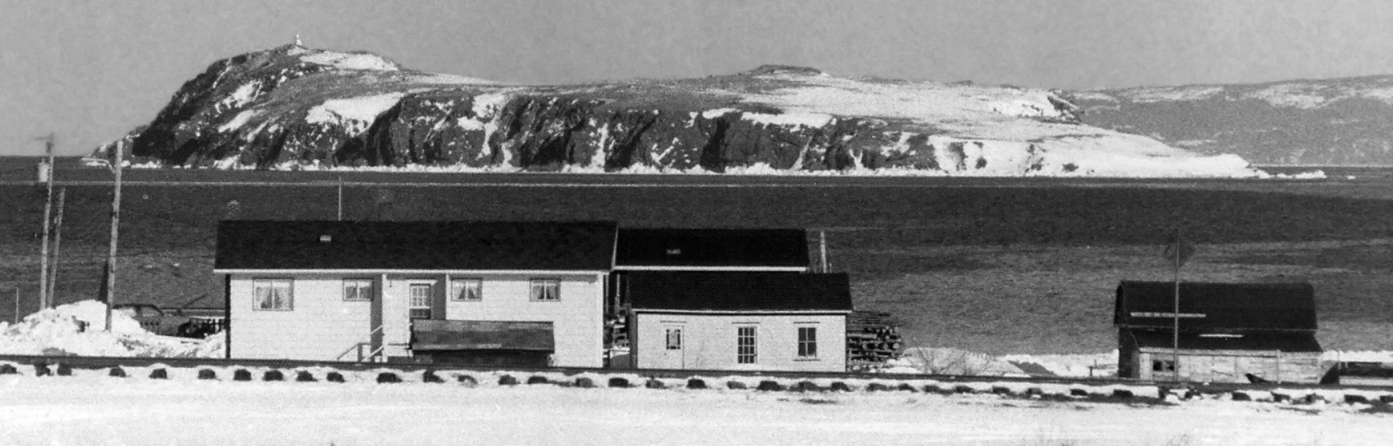
A zoomed in photo was taken from the south side of Carbonear Bay along the railroad tracks. The sloping Island with steep cliffs and hazardous currents is tricky to land on by boat. Learn more about Carbonear Island. Photo from Decks Awash April, 1987 Magazine in Memorial University of Newfoundland
Risky Business
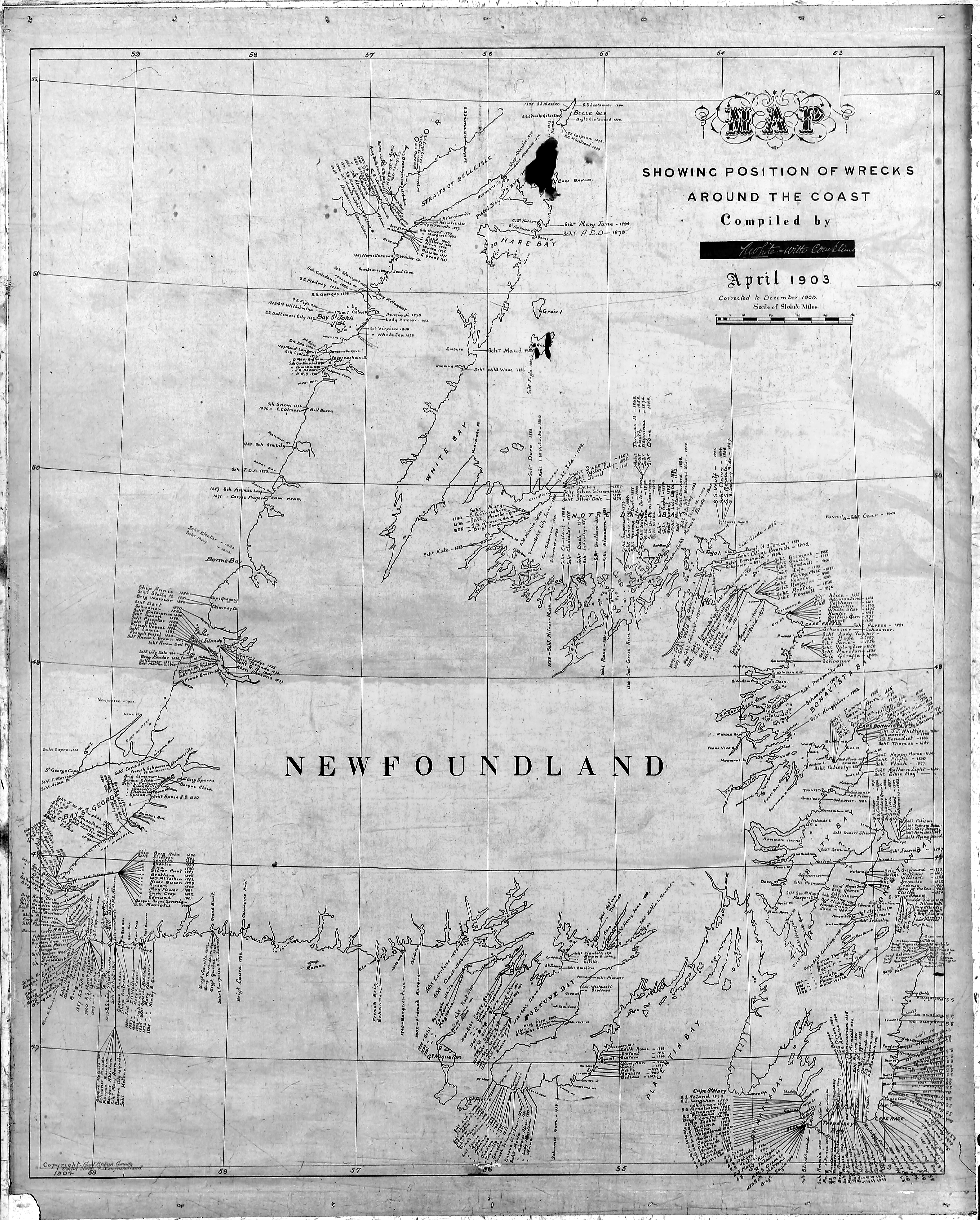
Unpredictable weather was the norm as fog, high winds, blizzards and rough seas would roll in at any moment. More than 7,000 wrecks line the coast of Newfoundland. During one weather event in June, 1901, a schooner left Carbonear and was struck by a violent storm causing her to loose her sails. The ship was pushed onto the rocks and tore out the bottom of the ship, flooding the living quarters. Survivors tied themselves to the deck rigging where they awaited their fate. After a night of ill fated rescue attempts in rough seas and a torrential downpour, the calmer morning allowed for the rescue of the nearly storm stripped survivors and unfortunate dead. Just a couple of years earlier, in September of 1899, a hurricane swept over the entire island, drowning many Newfoundlanders, destroying many fishing villages, boats and ships.
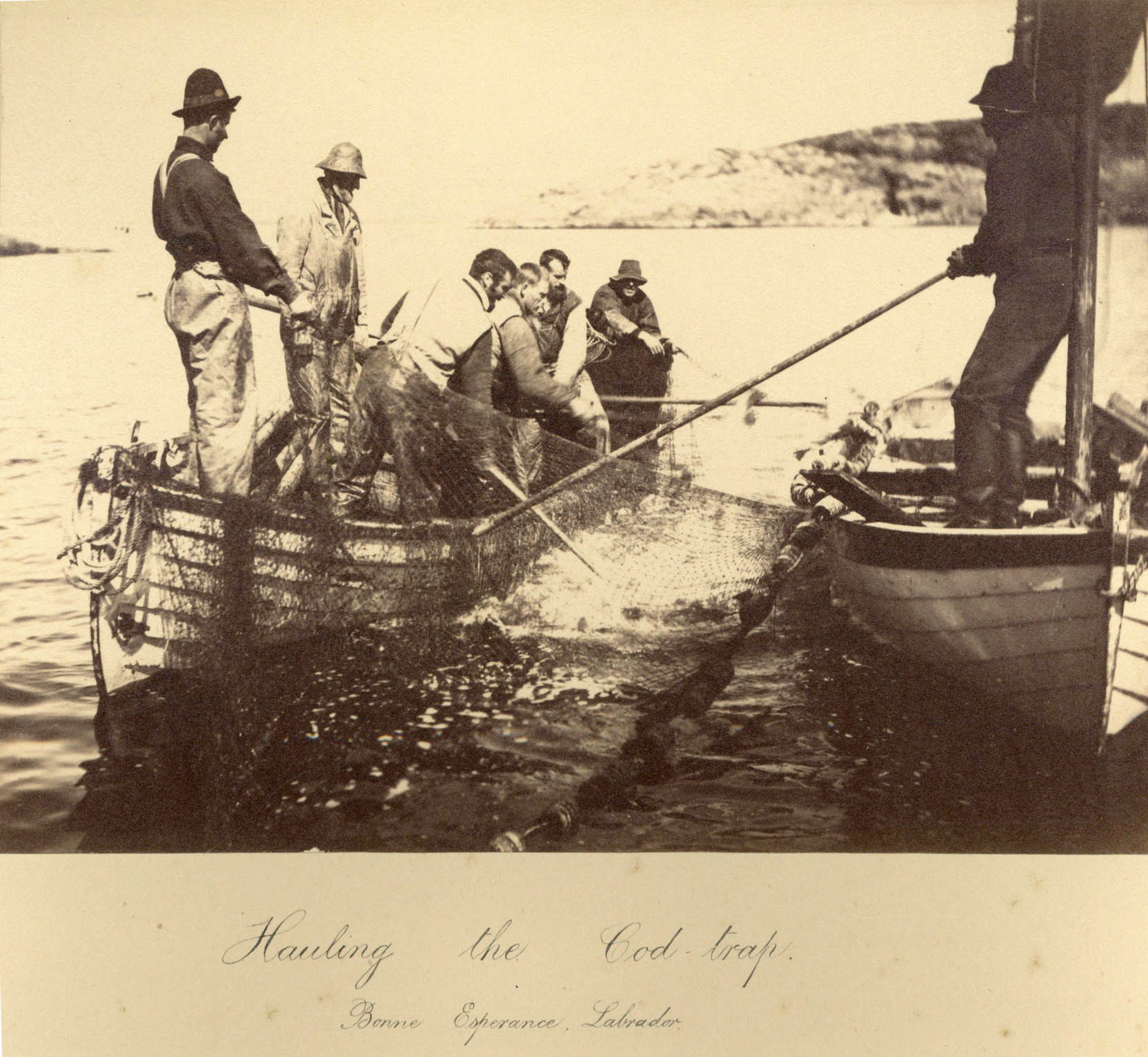
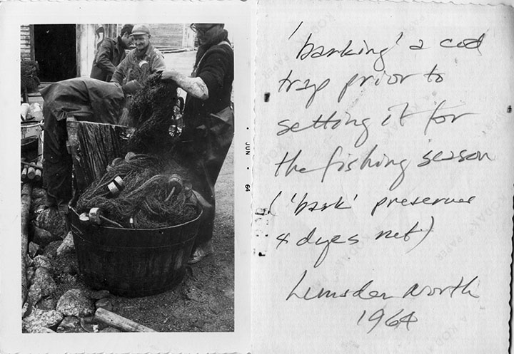
Many Clown's Cove and Freshwater families traveled north to find more fish and set up temporary fishing camps to prepare their catch. In a 1864 Labrador fishing village, the men work with their fishing boat with a pot or "barking kettle" over a smoking fire as a woman in long dress stands in the doorway of the timber and sod house while another family member looks out the window. Library of Congress.
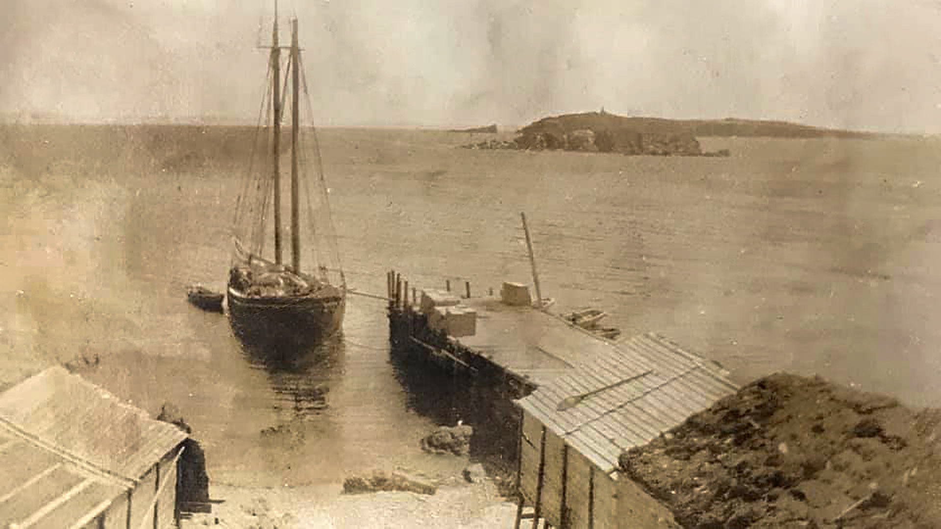
In a rare photo of a ship at Freshwater, the schooner "The Garland" owned by John Parsons and his brother Mark remains docked near the wharf. A plank runs between the ship and wharf, perhaps while unloading fish or loading supplies. The Garland sank in 1927 after a fishing season "down on the Labrador" near Triangle, about 30 miles north of Battle Harbor. The ever present, Maiden and Carbonear islands float in the background as fishing stages with storage sheds stand adjacent to the wharf. Notice the paddle on the roof of one shed and what looks like sod covering the roof of another. (Photo from Parsons relative on Public Facebook group - Freshwater, C.B., Newfoundland)
Despite the risks, many European countries fished for cod off the Grand Banks for centuries. The Clown's Cove area became a popular stopping off point for early 1600's sailors in preparing their fish and was labeled on some of the first international maps of the area including one from 1677. The area also had a near by source of fresh water - Freshwater Pond, which was most likely the origin of the town name.
Later, a few fisherman stayed and then their families arrived, populating the little area surrounded by rocky hills Newfoundlanders refer to as "tolts." Settlements outside of the original port of St. John's, or "outports," grew as coastal fishing villages became more populated with mainly English settlers, and industrious families built sod houses, fished the local waters, built stages for drying their catch, raised families and worked the land for hay and vegetables.
The Parsons were some of those early settlers called "planters" occupying shoreline fishing "rooms" known as "plantations." These "resident boatkeepers" or fishermen, are listed in Sir John Berry's Census of 1675. Joseph Parsons along with his wife, five children, three hired (and paid) fishing workers dubbed "servants," with having 1 boat and 1 stage and living in Clown's Cove.
The area grew as Davis families arrived in the area in the early 1700's. An 1800's home still remains as well as many graves at the cemetery close by. The Davis House was built around 1850, likely by George Davis and where Eli Davis resided, my great, great grand uncle. His brother William Davis (1850 - 1937) is my great, great grandfather. Eli's son, John Hayward Davis also lived in the Davis House. The home is similar to the rectangular homes pictured in the 1929 photo and is a Registered Heritage Structure of Canada and has been restored by the current owners and the Newfoundland Historic Trust.
Early living for these settlers was difficult as they had to survive the long winters, invading armies and even pirate raids as early as 1614 with minimal resources. Yet, despite the hardships, settlers continued to endure and prosper, supporting each other through hard times. Local families fished rough seas, endured harsh weather, and even rescued passengers from stricken ships.
The December 31, 1840 Carbonear Sentinel, reports Clown's Cove residents rescued survivors from the stranded St. Patrick, a "Packet Boat" transferring goods and people to and from Carbonear. The ship had struck the rocks off Maiden Island in a snow storm and was blown onto the rocks off Clown's cove in high seas. In the violent weather, residents at 6 PM, in the dark, heard the cries of survivors and manned a rescue. Locals including Richard Parsons, Richard Davis, Charles Moores, William Pottle, John Butt and others tied a line to the shore and threw the other end to rocks. In rough seas they pulled survivors from the stricken ship, rescuing many of the passengers and crew.
Ironically, on the same page of the Sentinel, an advertisement seeks passengers and packages and states that the same St. Patrick had been repaired and is making runs between Carbonear and Portugal Cove again!
Snow storms affected more than just shipping. According to Lawrence Coughlan, an appointed deacon by the Bishop of London for Newfoundland in 1766, "The winters in Newfoundland are very severe, there being great falls of snow and hard frost; the Houses there are mostly very disagreeable to those who are not used to them; in general they are all wood, the walls, so called are studs put in the ground close together, and between each, they stop Moss as they call it, to keep out the snow; this they cover Bark of Trees, and put great Clods over that, some are covered with Board in such houses I have been and in the morning my bedside has had a beautiful white covering of snow. My shoes have been hard frozen, that I could not well put them on til brought to the fire."
In the bitter winter of 1697 during King William’s War, French forces led by Pierre Le Moyne D’Iberville ravaged and burned settlements on the Avalon Peninsula including Newfoundland's Capitol, St. John’s. About 200 local residents around Carbonear area retreated to Carbonear island and fired upon the French with six pound cannons and refused D’Iberville’s appeal that they surrender. Days later, the French attempted to land on the island but were again repelled. Many more battles occurred and more settlements including Carbonear were burned. However, reports from local residents maintain the French never entered Freshwater as the strategic battery on Freshwater Hill manned with soldiers, a pair of canon and town residents also repelled the invading army.
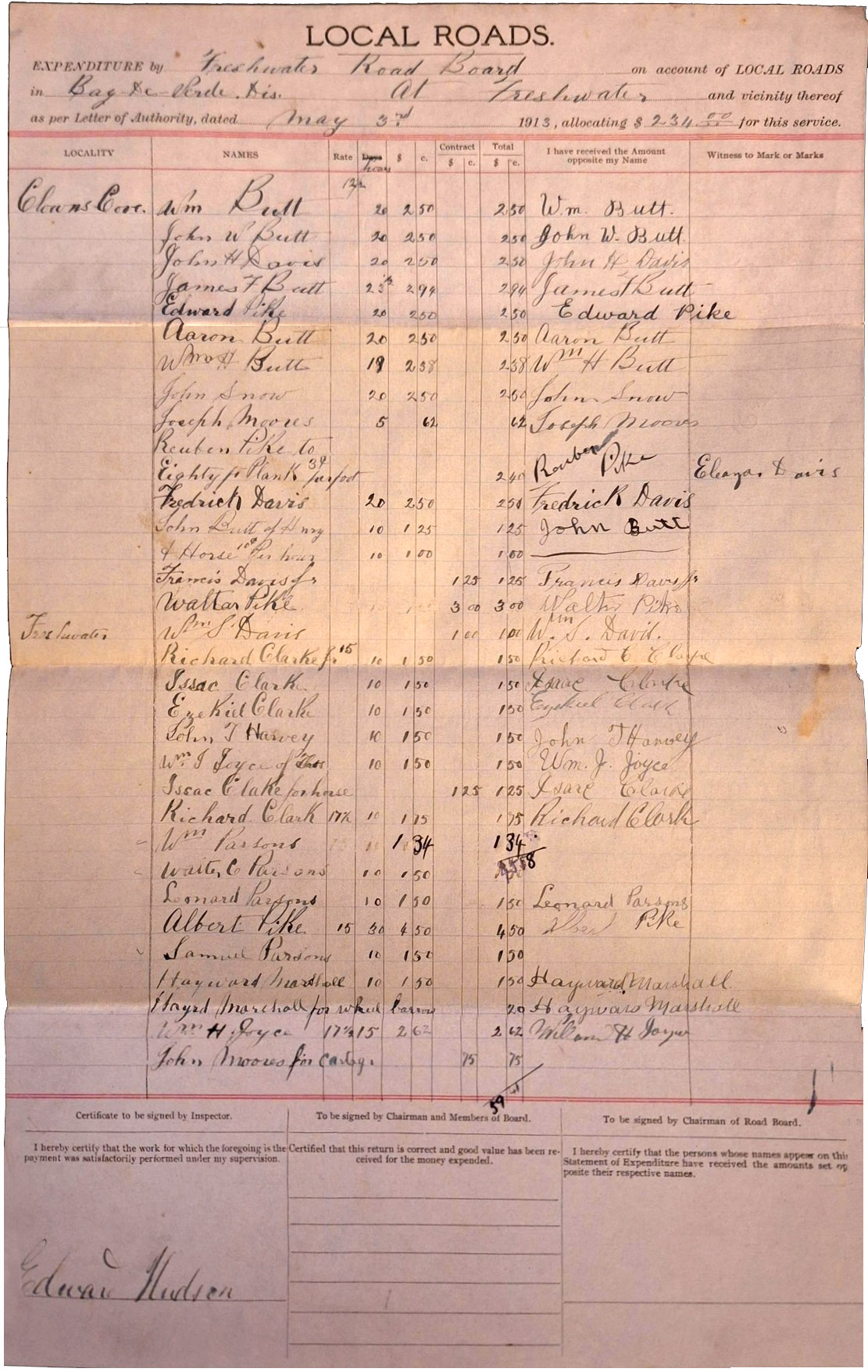
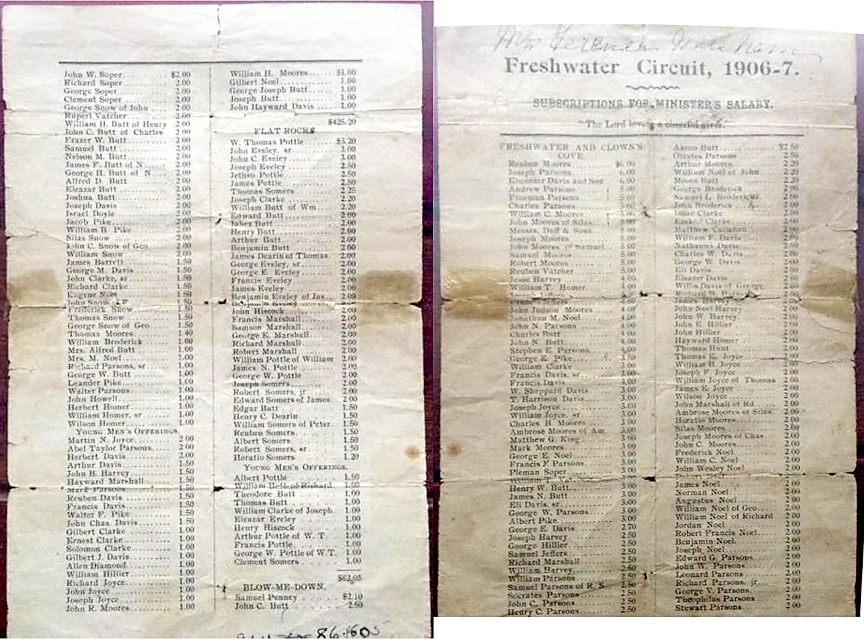
1805 Plantation Record for Clown's Cove and Freshwater, Newfoundland
by Bert Parsons and Dave Parsons.
Link and PDF text versions of records: 1805 records NLGenWeb
PDFs - Part 1 - 2 - 3 - 4 - 5 - 6 - 7
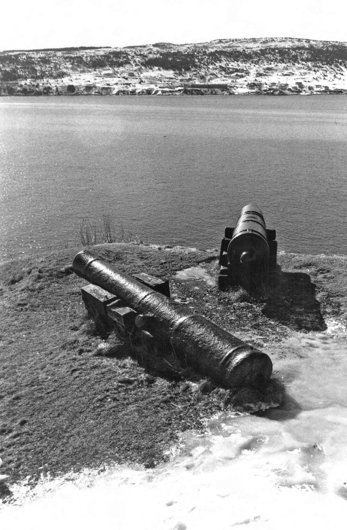
Once housed on Freshwater Hill, rusted cannons used to defend Freshwater and Carbonear from French and American Privateers during the 1700's, now look over Carbonear's Harbor Rock Hill. Until relocated, one of the canons remained in a local Freshwater resident's garden and the other was stationed on Freshwater Hill where a defensive battery or garrison once stood overlooking the bay. Photo from Memorial University of Newfoundland.
Learn more about the history of Newfoundland in, Early Settlers of Newfoundland written by Dave Parsons. Includes more photographs from my 2006 visit along with a general Newfoundland history. 21 MB PDF
Part of a copied 1675 "In New Found Land: A List of Planter Names..." showing Clown's Cove with Joseph Parsons along with his wife, 3 male and 2 female children, three hired men and having 1 boat and 1 stage. Memorial University of Newfoundland PDF.
Statistics from the 1858 Journal of the House of Assembly of Newfoundland shows a growing population in the 'Bay de Verde' area including Freshwater and Clown's Cove. Book from the Memorial University of Newfoundland.
The 1935 Newfoundland Census lists boats and fishing gear from towns around the Freshwater. Census from the Memorial University of Newfoundland.
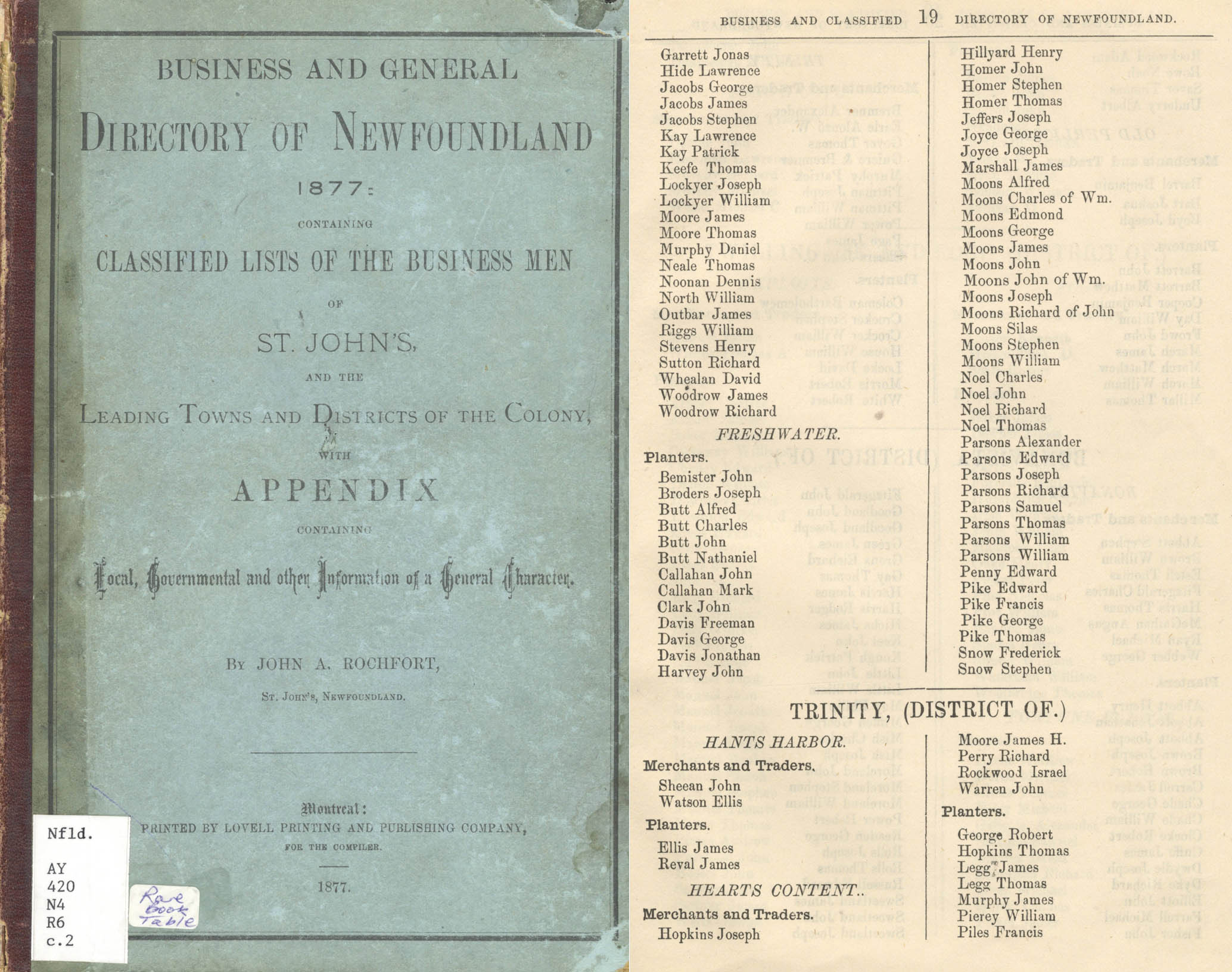
McALPINE'S Newfoundland Directory lists the residents of Clown's Cove and Freshwater/Carbonear from 1894 to 1897. Some residents like Eli Davis (1843 - 1931) are listed in both Clown's Cove and Freshwater. Eli is listed next to a William G. Davis, a carpenter in Freshwater. Nicholas Parsons (1845 - 1905), my great, great grandfather is listed as Freshwater fisherman and perhaps his father Richard Parsons and uncle Joseph Parsons are listed as Freshwater fisherman also. The tough part, if at all possible, is to identify the correct ancestor, as so many of the family names are the same.
Book from the Memorial University of Newfoundland.
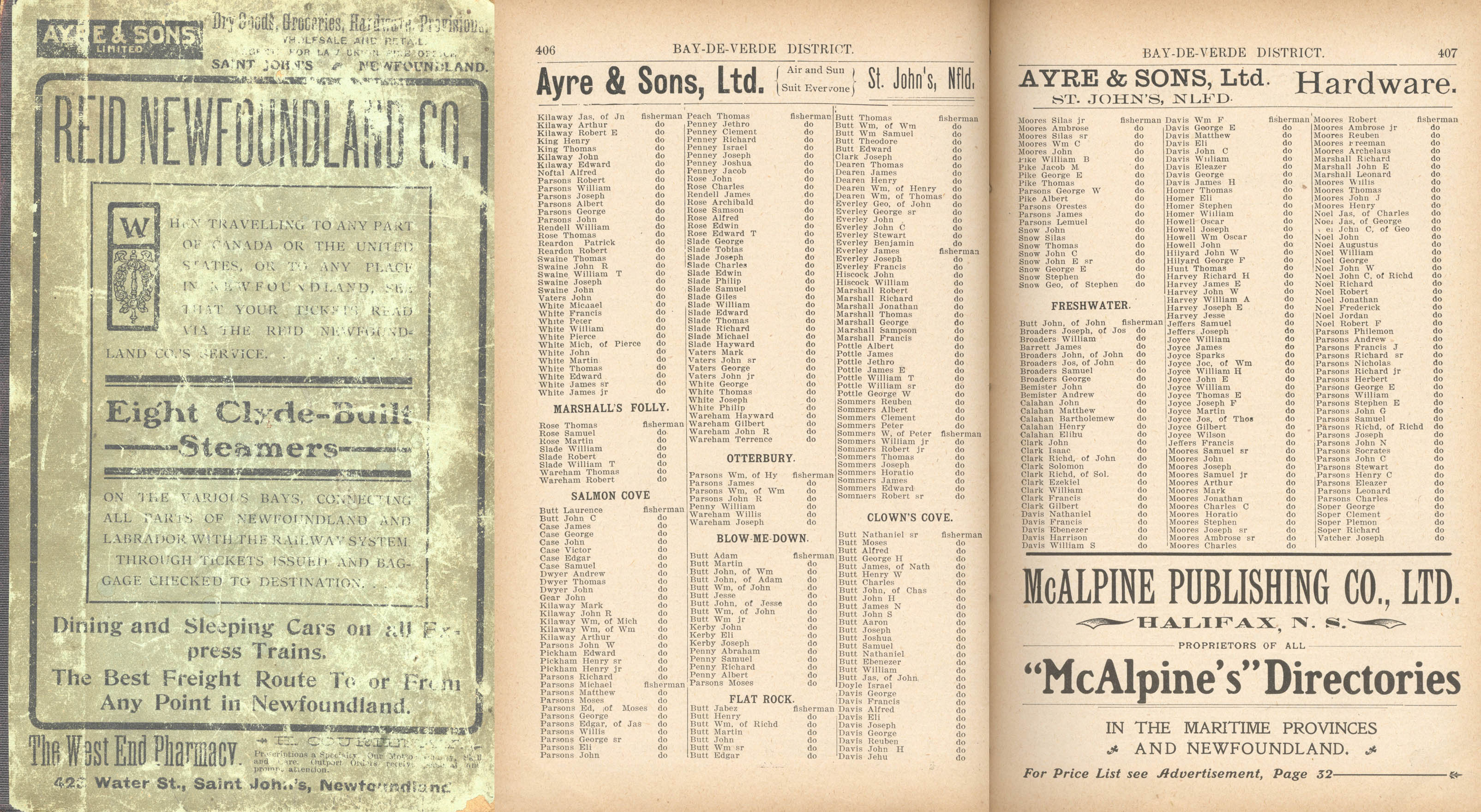
The 1904 Directory lists Clown's Cove and Freshwater fishermen, no longer planters.' Directory from the Memorial University of Newfoundland.
1709 Petition to Queen Anne from Carbonear and nearby residents sheltering at Carbonear Island asking for English support from French attacks. Signed by George Davis, Thomas Moores, Thomas Pike and other locals. Author colorized black and white Queen Anne document scan from David Pike's Family History and Genealogy Resources Page. Book page from Encyclopedia of Newfoundland in the Memorial University of Newfoundland.
Busy Conception Bay Coves
In the absence of war, Clown’s Cove and Freshwater with established planters or settlers with their homes, boats and stages began their part in a worldwide triangle trade of the north Atlantic. In a lopsided triangle that mostly benefited England, southern Europe imported tons of Newfoundland cod provided by the settlers and migratory fishermen, and they in turn exported wine and fruit to England which exported manpower and supplies to Newfoundland. Clown’s Cove and Freshwater were now considered resident fishing stations, supplying prepared cod for which they traded supplies. Passing trade ships were a life-line providing basic food stuffs and materials required for survival. In accounting records from 1731 to 1765, Simon and Nicolas Tocque traded such English supplies out of their Freshwater shipping business for fish from nearby Carbonear merchants.
Using a dual entry accounting system, "per contra," ledgers were filed throughout the years listing various supplies easily sold to the settlers, like salt, flour, bread, brandy, oil, fish hooks, etc. which arrived in the spring and were offset with a settlement payment of quintals fish in the opposite column, paid in the late summer and fall as the ships headed back to European ports.
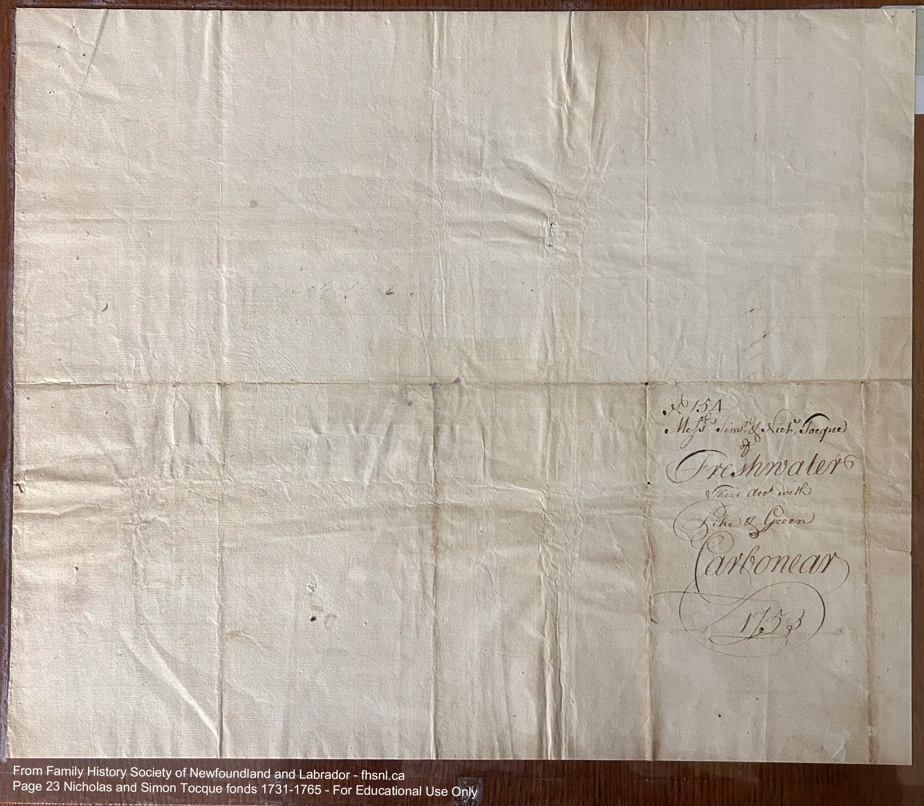
Freshwater shipping accounting documents from 1753 and 1761. Documents from Family History Society of Newfoundland and Labrador - fhsnl.ca.
In 1753, agent George Davis, with his accounting written in a flowery script, listed the English supplies of Simon and Nicholas Tocque, based in Freshwater with the cod supplies provided by the Pike and Green merchants of Carbonear. Simon and Nicholas (the debtors) arrived on May 19 with a laundry list or expense report of supplies from England, including nails, cordage, 1-1/2 gallons of tar, long lines, lead, one tin kettle, sugar, 12 large fishing hooks, English beef, barrels of flour, salt, molasses, gallons of rum (all listed in the left column). The total with a 14 pound "discomt" on the balance or "discount" left a total of just over 39 pounds of goods. The Carbonear fishing merchants (in the right column) provided 166 quintals fish on September 1st, worth over 112 pounds. As who wrote the check for the 73 pound difference was not accounted for.
In 1761, local Thomas Pottle accounted for the Tocque brothers and Pike and Green merchants again. There are additional payouts for John Moores of 2 pounds and John Parsons of 10 shillings among the list of supplies. On May 26, 34 pounds worth of supplies arrived, and on September 21, over 53 pounds worth of cod went out.
As trade continued, more of the typical small town needs like schools, stores and churches were established. Likewise, a court system slowly developed in defiance of England's control. Early on, any judiciary system in the settlements depended on the rough justice doled out by the attending fishing admiral. By 1812 Newfoundland settlers numbering around 30,000 built a rudimentary administrative system. In the nearby Harbor Grace, a court house was established and soon settling disputes. In one case, Freshwater residents in 1828 let the jury decide.
In the Harbor Grace Court Records dated from 1828-29, records survive of the following court case which saw Freshwater neighbors pitted against each other and resorting to the court system for justice. In the end, the jury voted in favor of the defendant, George Davis and against his neighbor and plaintiff, Joseph Parsons over a long simmering dispute over a fishing room #944, Jonathan Marshall's previously and its stage prone to collapse during rough springtime seas. What’s interesting is not just the squabble, but the people attending the case as the jury and witnesses. Deciphering the hasty cursive and abbreviations is challenging but, the reader eventually gets the idea in the following rough transcript.
(The plaintiff (Joseph Parsons) is the person who brings accusations against the defendant. The defendant (George Davis) is the party against whom charges are being brought.)
24 November 1828
Joseph Parsons Vs. George Davis - Case worth sum of 4 pounds being for the use and occupation of certain Premises at Freshwater from the 1st June 1820 to October 1828 as per annum.
Dft (Defendant) pleads General Issue
Jury Sworn
1828 - George Davis Vs. Joseph Parsons dispute in Freshwater. Harbor Grace Documents from Family History Society of Newfoundland and Labrador - fhsnl.ca.
William Parsons (of Jonathan) Freshwater
John Parsons
Robert Parsons (Bears Cove)
William Parsons (of the Plum?)
Jonnthan Parsons
William Parsons (Caplin Cove)
George Parsons (Harbor Grace)
Nathan Payne
John Payne (Harbor Grace)
Nicolas Payne
John Patey
William Penny
Mr Halls For Plaintiff W Anderson for Defendant
Deed Of sale dated 21 October 1806 from George and James Kemph and Co To Joseph Parsons the Pltf (Plaintiff) should forever certain premises at Freshwater with stage flakes took the property of Mr Marshall and others bounded on the W. by Ely (Elizabeth) Anderson -E by the Sea - on the NW by the woods Cons on 60 pounds.
Joseph Suppers Witness: knows Pltf and Dft (defendant) resides at Freshwater and is a Planter - knows stage near Dft Premises - knows the premises lot the property of Mr Marshall which has been occupied by Plaintiff for some years - Pltf and Robert Marshall built the stage together about 18 years ago on the premises described in the deed - Pltf and Marshall occupied the premises and carried out the Fishing together for 2 or 3 years - Pltf had potatoes and cabbages planted on the premises - the stage fell down about 8 years ago after which Pltf built it up - the stage usually gives way come spring with the sea -
Witness thinks the use of the ground where the stage is may be worth five shillings per annum. X knows that Robert Marshall had a brother called Jonathan Marshall (Room #944) who owned a part of the premises occupied by his brother.
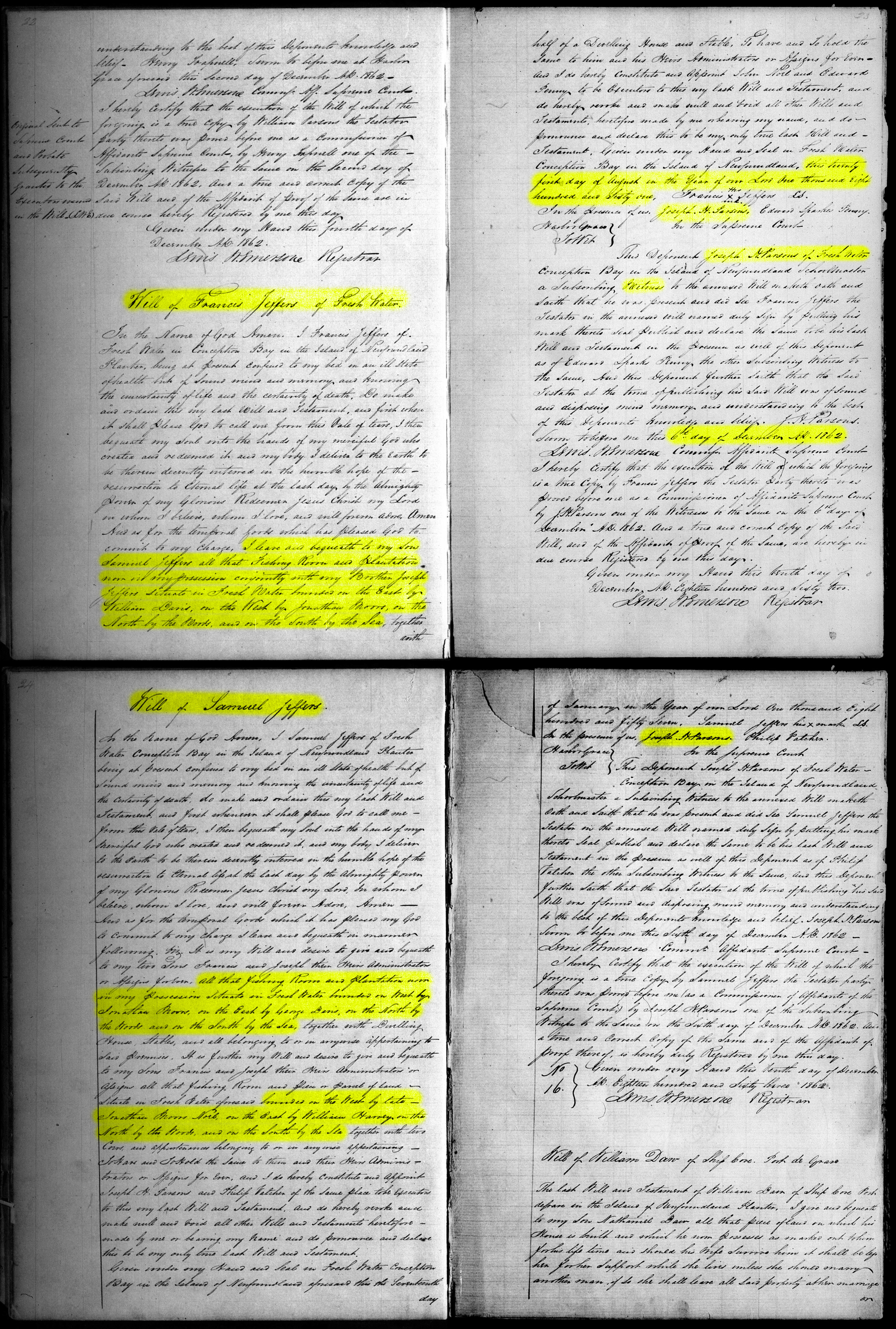
1862 wills of Francis and Samual Jeffers with his "...fishing Room and plantation now in my possesssion situated in Freshwater bounded on the west by Jonathan Moors and on the east by George Davis, on the north by the woods and on the south by the sea..." Wills Volume 2-fhsnl.ca.
William Moors Witness: lives at Freshwater knows the Pltf and Dft there is only one stage between Pltf and Dft premises - knows that many years ago Pltf purchased some premises from Kemps and Co and that Pltf has occupied them ever since. Witness thinks Pltf has occupied then premises for 20 years - part pf the stage was always considered the boundary - Dft has been fishing on the stage often of at all events for 6 years - the privilege for which the stage is worth 10 shilling a year.
Dft occupies the premises formerly Jonathan Marshalls (Room #944). Pltf has made no fish on the Room for several years. Joseph Parsons — recollects Dft paying Pltf Rent for a stage in 1818 - fit is a son of Pltf. Dft give Pltf one Quintal of Menhan table fish which is that year was 16 shillings. The Rent was paid Dft — Parsons on Pltf amount-
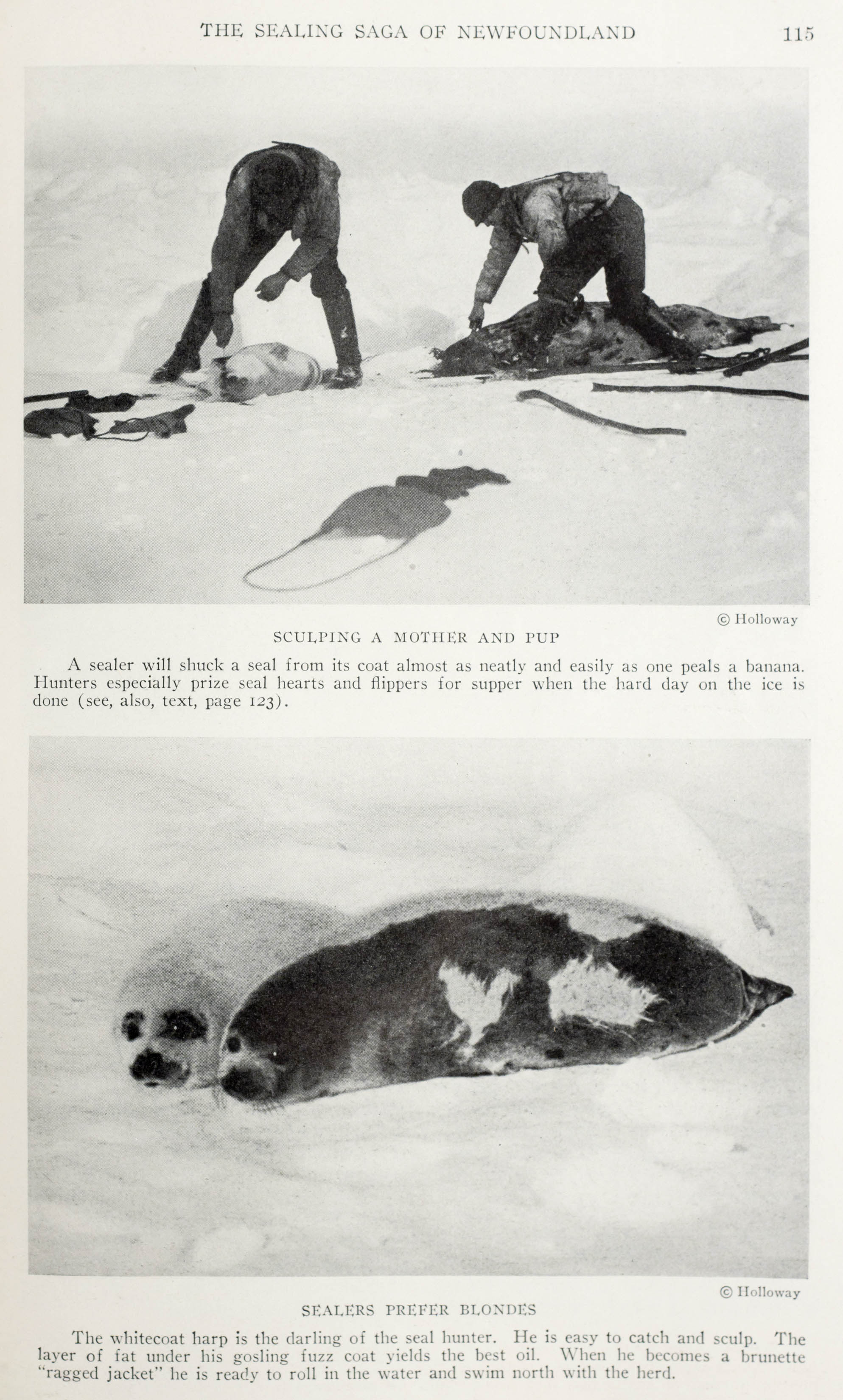
Plaintiffs Case closed
Robert Marshall W: Witness lives in Freshwater - the Western part of old Richard Marshalls Room (Room #945) was willed to witness and his brother Jonathan (who owned Room #944) - the certain part of the room was occupied by Richard Marshall swear William Marshall and Elizabeth Anderson - the Pltf now possessing what was sold by Kemph and Co, then. Dft holds what was Jonnthan’s premises (944).
North? sea washes south? Stage which is annually the wreck is divided and then taken away by Pltf and Witness - Pltf occupied the stage jointly with Witness for some years say five years. Dft still occupies the part of the stage which he purchased from Jonathan Parsons.
Jonathan Marshall Witness: Is son of old Richard Marshall (who owned Room #945) who once occupied the premises now possessed by Pltf (944) about 21 years ago. Witness sold his room to William Davis and which he again sold to Dft. The Rock upon which the stage is built is altogether and the part of the Room and opposite the Premises of John Sewell. Defts Room as some distance from the stage and does not adjoin it - the Rock belongs to the Room sold by Witness to William Davis and now possessed by Dft.
William Davis Witness: Lives in Clowns Cove sold to Dft the premises now possessed by him the rock was included in what Witness sold to Dft the premises now occupied by Pltf belonged to the first wife of Richard Marshall -
Verdict for the Defendant.
May 29, 1834 Mr. Thomas Parsons builds and launches the 91 ton schooner "Cordelia" from Clown's Cove, much like the ship being rebuilt in Placentia in 1928. Also in the same week another pair of Parsons, Mr. Joseph Parsons of Carbonear and Miss Catherine Parsons of Clown's Cove were married by Rev. J.G. Hennigar. News clipping from Canadian Research Knowledge Network. Photo from Memorial University of Newfoundland.
The busy fishing village also saw the construction of small fishing boats and large schooners destined for the seal fishery, a growing industry where outport families could make a little money. According to "The Star and Conception Bay Journal," of May 29, 1834, a few years after the court case, Mr. Thomas Parsons built and launched the 91 ton sealing schooner "Cordelia" from the beach at Clown's Cove for the owners of T. Chancey & Co. The bustling area was already busy with fishing as the ship construction must have been wedged in between the many stages. Cod was processed and dried on the small cove while trees were cut down from the interior and dragged by men and horses down to the beach and cut into shape.
Growing Businesses, Families and Organizations
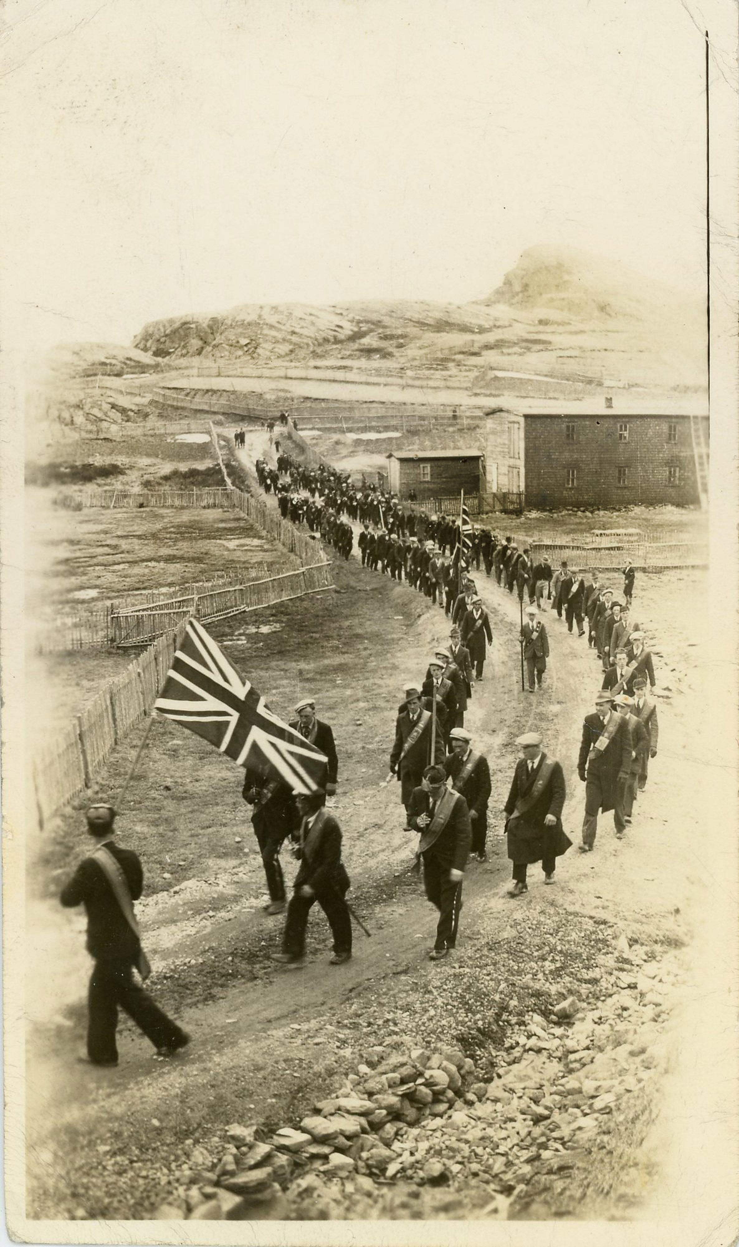
Walking in line, Freshwater's Orange Lodge #62 members wearing their sashes (link pictures sash from nearby Carbonear) walk Flatrock Road above Freshwater, past the buildings owned by Worley Noel. (Photos from Public Facebook groups - Freshwater, C.B., Newfoundland & Carbonear Heritage Society)
The Freshwater area continued to grow. In 1858, statistics show 145 people living in 21 Clown's Cove houses with 20 acres of 'improved' lands, all born in Newfoundland, mainly catching and curing fish and attending one school and one church. The cove had one horse, four milch cows, nine neat cattle and 29 swine and goats. Families produced over 184 barrels of potatoes and 13 tons of hay. With only two nets and seines, the village had 19 large boats capable of hauling 4 to 15 quintals (a quintal is an old English measure for 112 pounds (51 kilograms) of fish) and three large boats capable of hauling over 30 quintals. They cleaned, dried and processed 1,565 quintals of fish and produced 1600 gallons of fish oil for the year.
As migratory fishing ships from Europe filtered in and out of the area, they brought news and new faces and ideas. As information spread through the growing community, these introduced ideas and organizations or societies also took root. Two that developed early on were the Methodist Church and the Loyal Orange Institution.
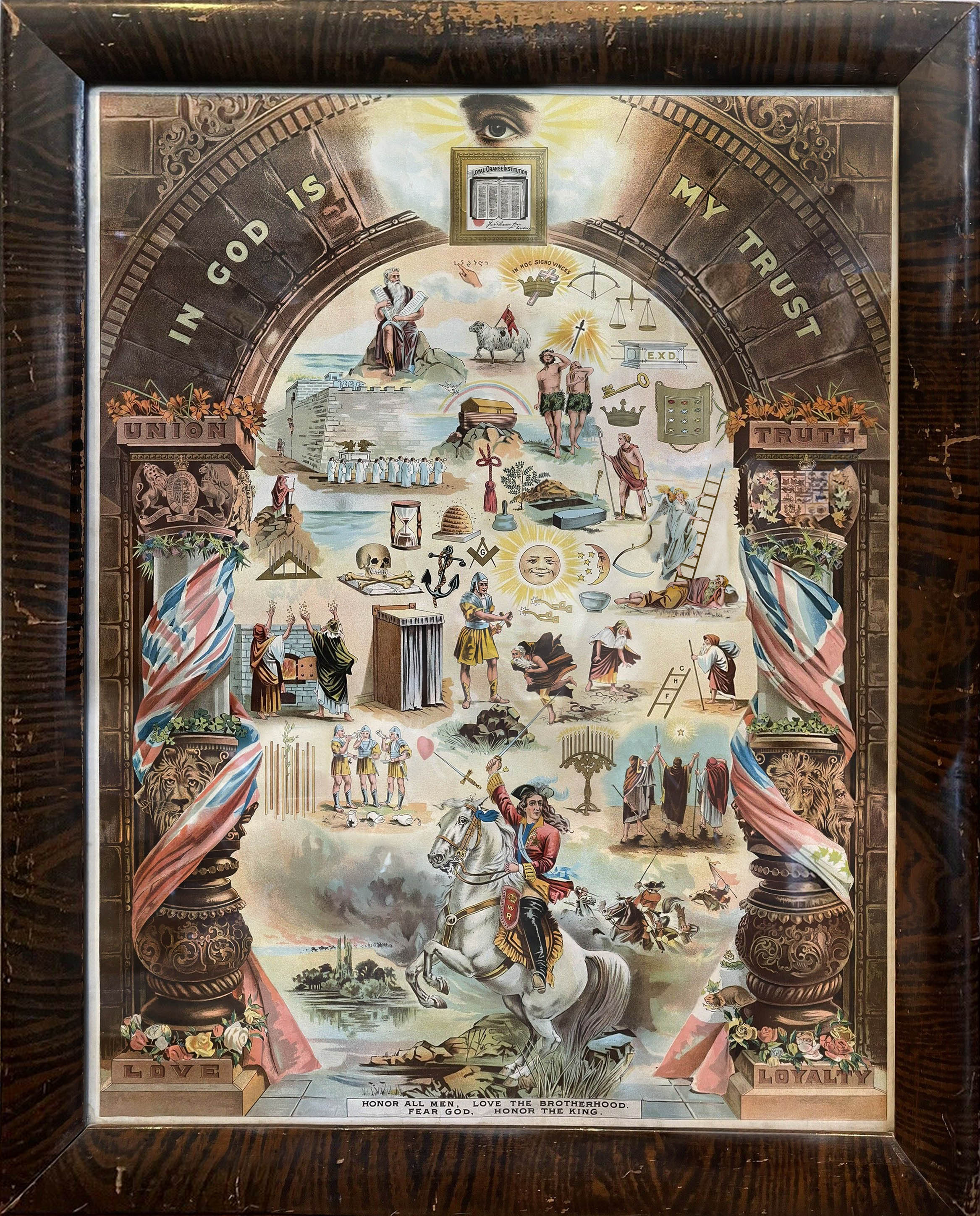
The Protestant, fraternal Loyal Orange Institution was based on William of Orange or King William III. On a early 1900s poster depicting twin pillars and an archway, the sword wielding horseback rider, King William III, rears up in the 1690 Battle of Boyne. The same pillars and archway are depicted on the outside of the Orange Lodge buildings. The "benevolent and friendly society" sought to provide financial and moral assistance to those members in a time of sickness. Photo from Ebay.
The Loyal Orange Institution also known as the Orange Lodge and Orange Order developed as a result of the Protestant Reformation, the Glorious Revolution of 1688 and the never ending battle for religious supremacy between Catholicism and Protestantism.
During the Battle of the Boyne, fought on July 1, 1690 in Ireland, the Catholic Jacobites were defeated as the deposed King James II fled back to France and the Protestant, William of Orange established himself firmly on the English throne as King William III.
The battle, the largest engagement on Irish soil and a defeat for French king Louis XIV, William’s long time foe, was crucial in securing the spread of Anglican Protestantism in Ireland. Significant for Irish Protestants, an organization was later established in 1795 known as the Orange Order derived from William of Orange and was designed to defend Protestantism in Ireland. As a result, the image of William III of riding his white horse with sword drawn and the dates 1688 and 1690 were emblazoned Orange Lodge banners, member vests, medals and printed material along with other fraternal and biblical symbols.
The characteristic twin pillars and archway are depicted on the outside of the Orange Lodge buildings. A flag pole also stands above both buildings. The earlier lodge in the 1900 photo was most likely built in the 1800s (original photo B-4-76 from The Rooms Provincial Archives). The lower photo taken in the 1980s shows the lodge that was built in 1911 near the same location as the first. Residents remember playing darts and having dances there as well as Monday night Lodge meetings. (Public Facebook groups - Freshwater, C.B., Newfoundland).
That Protestant pride spread from Ireland to the settlements in Newfoundland and Canada in the form of the Loyal Orange Lodge (LOL), a fraternal organization memorializing the efforts of King William III. The "benevolent and friendly society" with their mottos "In God is my Trust" and "Honor all men, love the brotherhood, fear God, and honor the king," formed their Society "for the purpose of assisting each other in time of sickness" according to a 1861 LOL pamphlet.
Also spreading at the time in Freshwater and Conception Bay was the influence of a new Christian denomination, Methodism, a Protestant belief rivaling the Church of England which involved logic and reason "in all matters of faith." The inclusive religion, known for its rich musical tradition, followed the teachings of an British Anglican cleric, John Wesley and was introduced to Newfoundland in 1765 by evangelist Lawrence Coughlan. Initially slow to gain ground, by the mid 1800's, Methodism spread to most of the island which succeeded in establishing an educational system of building schools and combating illiteracy.
According to the History of the Rise and Progress of Methodism (PDF from Canadian Research Knowledge Network) written by Reverend Charles Lench (PDF from MUN) in 1911, "Freshwater for more than 100 years was an appointment of the Carbonear Circuit. The Rev. Lawrence Coughlan used to pay regular visits to the settlement and obtained converts there. Mr. Clement Noel and Mrs. Parsons corresponded with him after his return to London, England, and incorporated the correspondence in his little volume, entitled: Seven years missionary work in Newfoundland. Twenty-nine years ago Freshwater became a separate Circuit." Lench continued, writing "Freshwater has had a splendid band of lay-helpers" and listed numerous residents with their contributions, hard work and efforts. He also wrote, during the ministers absence, "Messrs. Richard Penney and Terence Butt, with Edgar Kelloway and William Parsons, are holding the fort" and "Thus every appointment is cared for in the minister's absence. The Noels, Homers, Parsons, Moores and Butts have their successors to-day."
In an interesting side note, about the same time Reverend Charles Lench was writing his history of Methodism in 1911, he was also photographed in Newfoundland around the Western Bay area along with the churches, fisherman and residents of the area. Likely commisioned by the church to promote and document missionary outreach, the professional photographer, shooting a wide array of stereoview photos also documented Freshwater, in likely the only known stereoview of the town. The Reverend was photographed with prominent community members as well as fishermen and the local kids.
Likely commissioned by the Methodist Church, an early stereoview looks over the homes and few small boats in Freshwater Bay. It is one of the few, if only, stereoviews of Freshwater - and the 3D works! The photographer or likely the wind shook the camera on the tripod as the image is slightly blurred. Photo part of public domain. See the other stereoviews and watch the CBC videos - October 15, 2024 CBC article and video and January 11, 2025 CBC follow up story.
The professional photographer also took photos in the small communities within what is now referred to as Conception Bay North, like Western Bay, Tackers Cove and Small Point-Adam’s Cove-Blackhead-Broad Cove. There is also a view of St. Johns.
Stereoview photography was rare and expensive in Newfoundland at the time. According to the CBC video, it was likely Frederick Stevenson, once an employee of the Underwood and Underwood stereoview company until 1902 and later a United Methodist Church Secretary overseeing foreign youth missions documenting the works of the church among life in small Newfoundland outport villages. This included the missionary travels of Reverend, Charles Lench (pictured below) who was also writing his book titled "The History of the Rise and Progress of Methodism on the Western Bay Circuit…" published in 1912. Notice the same Western Bay Chuch was photographed as a stereoview and for the Reverend's book. The photographer is unknown, however, there may be a reference in the caption within the church photograph in the book which is difficult to read: "METHODIST CHURCH, WESTERN BAY DISTR B.V. NFLD."
As Methodism grew, eventually, Freshwater even gained its own Methodist Church newsletter first published in 1918, The Freshwater Recorder, a monthly magazine with local advertising that posted relevant information about church life and news in and around the communities at Freshwater, Flat Rock and Otterbury. Subscriptions cost 50 cents a year.
The Freshwater Recorder first published in 1918, was a monthly Methodist Church magazine with local advertising that posted relevant information about what was happening in and around the communities and churches at Freshwater, Flat Rock and Otterbury. Subscriptions cost 50 cents a year. (From Bert Parsons Collection - Carbonear, NFLD)
Both the Methodist Church the Protestant Loyal Orange Lodge and even schools seemed to grow in tandem with many of the small outports including Freshwater. In the 1900 panoramic photo of Freshwater at the top of the page, the Methodist school stands just a few houses down from the Orange Lodge, with its two pillars and arch over the doors. A later Orange Lodge was constructed in 1911 near the same location on the waters edge. The second Methodist church constructed, the Freshwater United Church was built in 1881 and stood on the high ground overlooking the small fishing village.
After steady gains in late 1880s, the Freshwater population took a hit soon after during a fishery collapse in the 1890s, but began to rise from 1901 into the 1920s. The prosperous times in Freshwater resulted in a larger, third version of the church, one that would be built in 1926 on the same location as the previous church.
Arriving later on the scene was The Fishermen's Protective Union which was established on November 3, 1908, by William Coaker and nineteen other fishermen. Looking to address the economic, social, and political disadvantages faced by fishermen in Newfoundland, its goal was to create a cooperative movement that would ensure a fair distribution of wealth in the fishing industry and provide fishermen with greater control over their livelihoods. The union's motto, "to each his own," encapsulated its mission to empower fishermen and promote equitable practices within the industry. According to Coaker, fisherman, loggers and sealers, otherwise known as the "toilers," they had a need, "to revolutionize the fishing, political and commercial interests of the country, in a manner that will ensure for the toiler a more equal vote in the Government of the Country, as well as secure a square deal for those engaged in the fishery..." (W.F. Coaker: 1930, pp. 5-6)
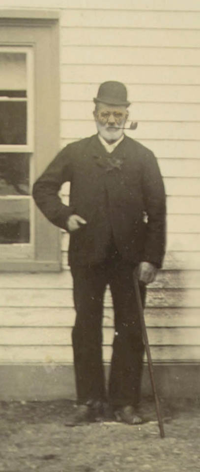
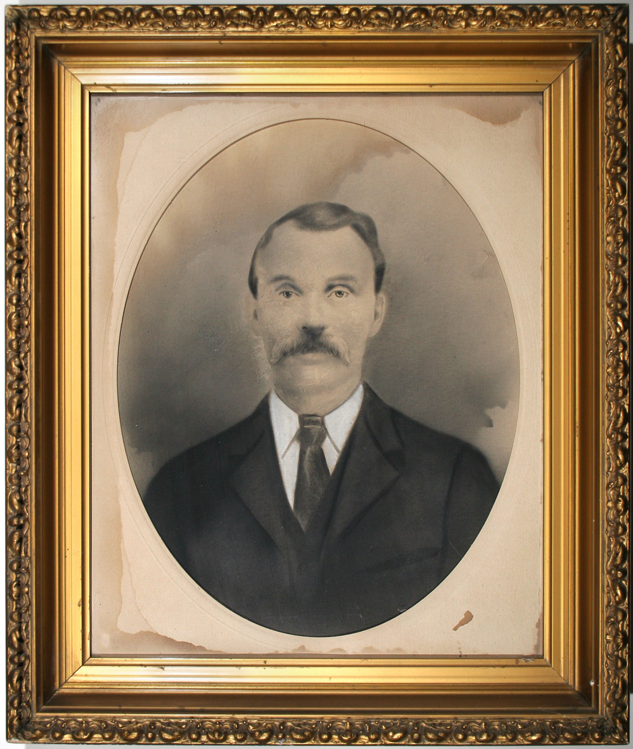
The authors artistic representation of William Davis combining three different people and adding his cane and boulder hat in front of church per Graham Butt's description.
To communicate, the FPU had its own union newspaper The Fishermen’s Advocate (was published in Port Union until the 1980s), which provided members with information about the union's activities, as well as news that would enable fishermen to bargain with merchants from a stronger position. "By 1914, the Union boasted more than 21,000 members in 206 councils, over half of Newfoundland's fishers. While the Union was unique in the Colony, its structure was based on the democratic principles of fraternal organizations familiar to fishermen, especially the Orange Lodge." However, after its final annual convention in 1939, the union began to slowly fade away and despite surviving post-confederation, by the 1960s, it lost its political force.
The "right steep" roof of the William Davis house stands to the right of the rocks with sheds, and a barn. (original photo B-4-76 from The Rooms Provincial Archives).
Today, in Clown's Cove and Freshwater, many of the homes built in the days when cod fishing was booming have disappeared. An open field is all that remains of my great, great grandfather, William Davis' house which overlooked Maiden and Carbonear Islands.
According to Graham Butt, a longtime resident describing the old Davis house, "the roof of the house was right steep you know." So steep in fact, according to Davis in his letter in 1931 to his son George, "I got the felt for my house but I can’t get nobody to help me to put it on. I suppose we'll have to try and put it on ourselves. The misses will have to put on pants and get up on the house with me and I tell you it's no load on her to climb on the house although she is seventy."
Graham also remembered Davis’ later wife Flora Pye Davis "the old lady, she used to make molasses hops and sell them to the kids going to school." Graham continued about William: "Oh, I remember him, he was a tall, tall straight man and he'd always walk with a cane you know and he'd go to church and he'd have that boulder hat on you know." (boulder hat - looked like a upside down bowl with a rim on it). "And he’d used to talk in a right loud voice. His brother used to live over there (pointing to the Eli Davis House) - with John Hayward’s father - Eli and his brother George" (see the video below).
Another artistic version of what William Davis and his home would have looked like around 1900 with the old school, Mosquito Point, Maiden and Carbonear Islands in the background. The ladders on the roofs would be used for the constant chore of cleaning the chimney to prevent fires. Glacially rounded rocks surround the nearby hillsides and tolts. Artwork by Dave Parsons
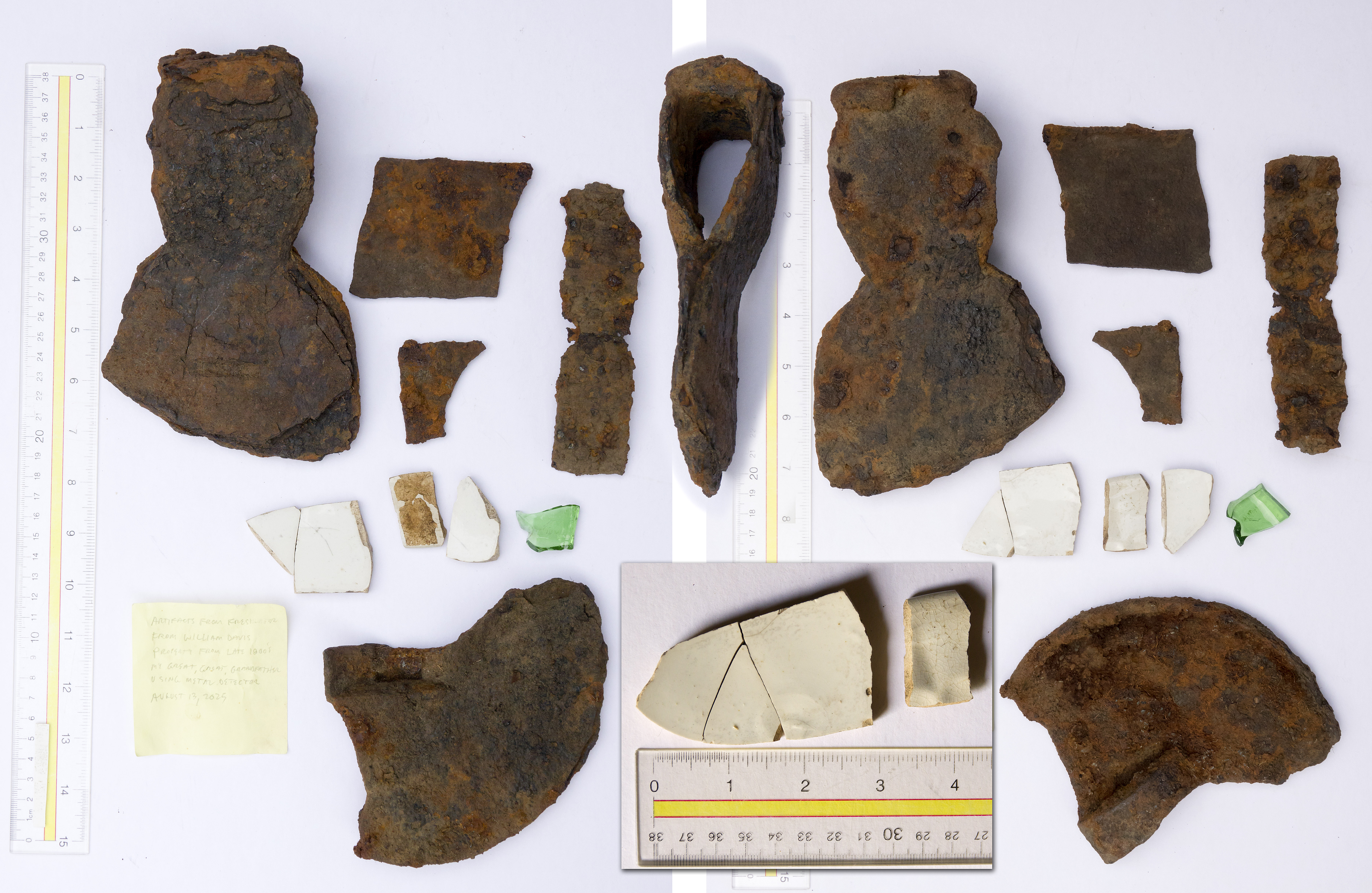
With permission from an adjacent property owner, I used a metal detector in a ten foot square area in the tall grass and found a few artifacts including an axe head, cast iron pot lit and dish fragments 6 inches beneath the surface top soil on William Davis' old property in Freshwater, Newfoundland on August 13, 2025. The recent shard of green coke bottle was found only a couple of inches below the surface. The area was located near the fenceline corner near where the Davis storage shed and home once stood (1900 photo) and was pointed out in 2006 by Graham Butt and pictured in the open lot photograph below. On August 13, 2025 the plot was completely overgrown with trees and shrubs.
The axe is an earlier form with notches in the sides and not straight sides and likely dates from the late 1800s to early 1900s. However, there are similar axes from the 17th and 18th centuries from archaeological sites around the Avalon Peninsula. Finding the axe head and dish fragments just feet from the homesite of William Davis and his first wife Jane Moores makes me think of the possibilities they once cut firewood with the old axe and used the dishes at meals for years.
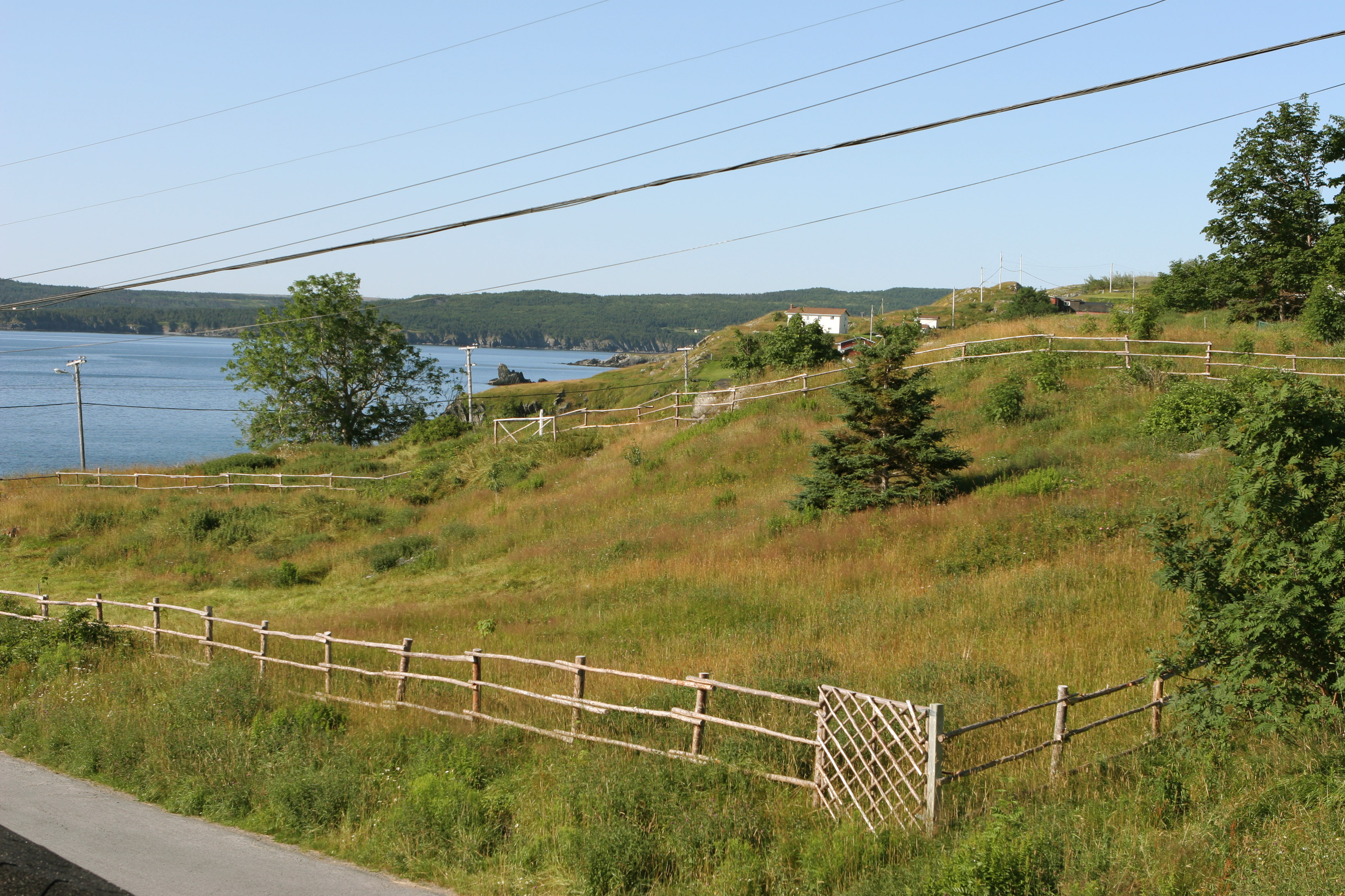
July 20, 2006, Graham Butt pointed out the fenced off empty field as the old Davis property. Slight depressions in the hillside indicate where the home and barn foundations once stood near the corner of the fence line in the foreground. In the background, tall rocks rise out of the water. Named Tucker Mills Island after two young men who drowned while getting from their boat onto the rocks to hunt sea birds. (Dave Parsons photo)
Another view of the Davis family property with the Clown's Cove tolt in the distance in 2006. (Dave Parsons photos stitched together)
July 21, 2006 - Standing on the edge of Parsons Lane with the Clown's Cove face and tolt in the distance as well as the road leading to Flatrock. (Dave Parsons photos stitched together)
Stereoview photos of Clown's Cove tolt and Clements Cove motorboats today during a calm day. (Dave Parsons photos)
Dark Clouds on the Horizon
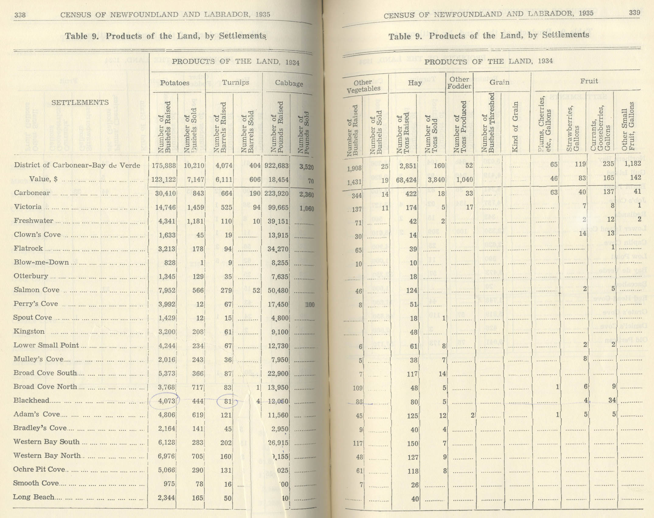
After the steady growth through the 1910s and 1920s, the hard times of the Depression hit and the market for fish dropped steeply. In 1934, Clown's Cove had 42 families in 40 houses with 24 acres of improved land and 13 motor boats and no fishing schooners. Families owned 18 cod traps, 5 salmon nets and 4 herring nets (pgs.74-5). They grew a number of crops and harvested 1,633 bushels (60 pounds/bushel) of potatoes, 19 barrels of turnips, 13,915 pounds of cabbage and 30 bushels of 'other' vegetables. They produced only one more ton of hay than in 1858, 14 tons total.
During that time, many fishermen took other jobs in mining and the lumber industry throughout Canada, as well as other jobs in the United States. According to a long time Freshwater resident,
"Those fishermen - some went to the U.S. to work in the summer, usually in construction. My father was a fisherman and a miner who went to Nova Scotia if he didn't get a good year fishing. Many people did that and went away in the fall mining and came back for the next fishing season... My father was doing that even before I was born and a lot of others from neighboring communities - it was a backup for fishing. In 1935 there was a big storm in August - most of the boats came ashore and broke up and that was the end of the inshore fishery in Freshwater and Flatrock." (Memorial University of Newfoundland)
The Davis and Parsons family members are listed in the Lovell's 1871 Newfoundland Directory. Directory from the Memorial Univ. of Newfoundland
Fishing became even more difficult for the local inshore fisherman as industrial fishing fleets became highly efficient and technologically advanced forcing many families to look for job alternatives. An earlier fishing market collapse in the 1890s must of have surely influenced my 3rd great grandfather Nicholas Parsons and his family to look for a better life and immigrate to the United States soon after. Furthermore, census statistics show wages were higher, two to three times higher, in other industries like carpentry. Likewise, the 1930 Chelsea Massachusetts census shows my 2nd great uncle, George William Davis, who was born January 14, 1890 in Freshwater, obtained his citizenship in the U.S. in 1898 and worked as a carpenter/contractor and later in 1940, a carpenter at an electric plant.
Unfortunately, as overfishing became more common, the busy fishing village of Clown's Cove, once with a long wharf and stages for drying cod fish began to suffer hard Depression years. For William and Flora who stayed behind in Clown's Cove, just surviving was a challenge. On May 26, 1931, William wrote to his son George:
"Sorry to hear the times are so bad in the States and that you have done nothing since Xmas but let it be never so bad in the States it’s not as bad as it is in NFLD for there’s hundreds and thousands don’t know what they’re going to do this summer. The whole country is in a confusion and don’t know what’s going to be the end of it...
The weather is getting fine here now the summer is come but the fish and salmon are very scarce. I tell you there’s not many stages built on Clown’s Cove this summer. The capelin will have lots of room to run ashore this summer. Uncle Eli and Uncle George is not much of it neither one of them. John Hayward is home walking about don’t know that he’s going to do this summer and hundreds more like him."
William Davis original letter from May 26, 1931 describing the Depression and lack of work and trying to put the felt on his house. Parsons Collection
With everyone out of work, getting enough money for food was a challenge. Just a few days earlier on May 20 George sent some money to his father just in time for them to purchase a new barrel of flower. William writes back with a bit of additional news adding insult to injury for the nearby town of Carbonear. According to William:
"Well, George, my boy, I received your letter on Saturday and more than thankful to you for the present that you sent to me and thanks to you very much for it for it came in a very good time to get a barrel of flour as our flour is just about out now and it is getting fine and cheap. 5.20 a barrel as we haven’t had one since October and this is May so I don’t think that we have anything to grumble at in regards of extravagances in flour."
William Davis original letter from May 20, 1931 thanking his son and describing the fire in nearby Carbonear. Parsons Collection
"I must tell you that first night there was a terrible fire in Carbonear. There was 14 homes destroyed in all and Billy Mores place that was Mr. Duffs big brick building was burnt flat to the ground. You know that he sold it last year to Mr. William Mores from Freshwater and all of Saunders and Howell’s factory and the boot and shoe factory and Maddock’s place and Leonard Ash’s and all the lumber yard there was pieces of paper and felt came down here and pitched in our garden. So that is all of that now I must tell you that I am tired tonight for I was working hard today in the garden clearing away and working out the ground to set our few potatoes in and the misses is cutting the seed to begin tomorrow or next day. You know that it don’t take much to make me tired now as I will soon be 81 years old and Mrs. Davis will be 70 the 8th of August so you see that we are not young but thank god we are both gifted with health and strength..."
As malnutrition and poverty spread throughout the island, most Newfoundlanders were barely surviving on inadequate relief payments and a food assistance program known as the "dole" (PDF). In 1935, William and Flora were sick for weeks and his nephews couldn't take them in. So Flora's son, Frederick Pye, from the town of Victoria, just to the north of Freshwater took them in. The Pye family nursed them back to health.
William Davis lived to be 87 years old, and died in bed in his Freshwater home in 1937. Sophia Davis wrote to Bertha Davis Parsons about her father stating she was with him "till the last" and "if you and I make such good ending like your father we will be all right."
Similarly, as many of the older generations died off and over exploitation of the cod fishery became more common, younger generations looked for different opportunities in the cities and abroad.
Likewise the population of the Freshwater area seems to follow the boom and bust cycle of the cod fishery with the population peaking before the 1930s Depression and then declining afterwards.
As cod exports declined through boom and busts, so did the population trends of Freshwater, declining through the 1930s. (Maritime History Archive - Public Facebook Page)
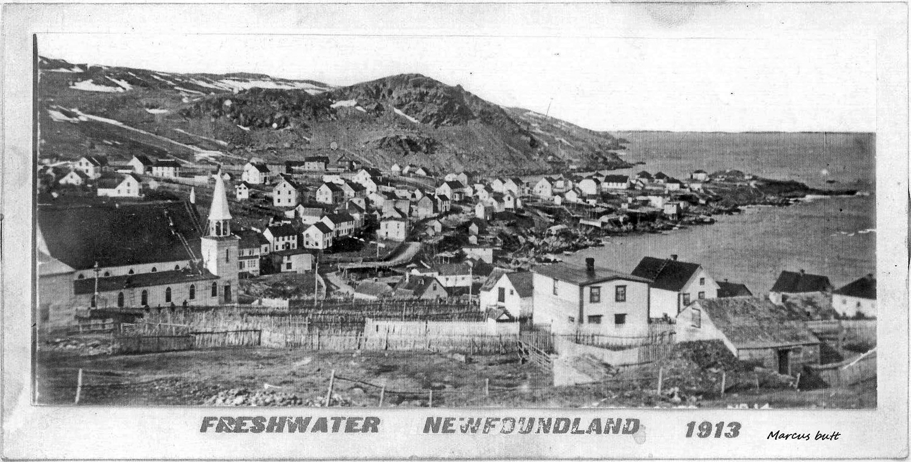
Freshwater comparison photos looking eastwards towards Clown's Cove Head. The pairs on the left were taken about 1913 with the old church, multiple wharves and lots of boats in Freshwater Bay. Its comparison photo, perhaps taken in the 1960s still has its dirt roads. The pair on the right was taken after the 1926 construction of the new church, perhaps in the 1930s as there are fewer homes than the 1913 photo and significantly fewer in its companion photo. Through the decades, there was a significant drop in the amount of homes and populations as data suggests. (Photos from Public Facebook group - Freshwater, C.B., Newfoundland)
Freshwater was one of the earliest settlements in Conception bay and early on had a population of 22 in 1696 according to Abbe Jean Baudoin’s journal (accompanied le Boyne d’Iberville in 1696-7 French raids). The following census data shows some fluctuations, but the population rises for Freshwater from 1901 to 1921 and is then followed by a heavy decline after the 1930s into the 1940s with a slight rise in the 50s and then steep decline leading to the 1990s. Clown's Cove data suggests the same trends.
1836 hand written Census of Conception Bay, Newfoundland with Freshwater and Clown's Cove counted together. (Records from Memorial University of Newfoundland).
Fishing collapses occurred throughout the 1970's, 80's and 90's, caused by improvements in technology and massive foreign trawlers fishing year-round. The final death knell for fishing in Freshwater and Newfoundland was the was the federal moratorium on cod in 1992 (PDF). A way of life that had endured generations ended as 30,000 people were put out of work. Fishing equipment and boats were sold and much of the outport population that had not moved in the 1950's 60's and 70's centralization (PDF) and resettlement programs (PDF) moved towards the larger towns once again and Clown's Cove turned into more of a small suburb of city of Carbonear.
An "old time ditty" written about 1890 for fisherman reminiscing about the out harbor or outport planters from long ago. From the 1923 book in Memorial University of Newfoundland
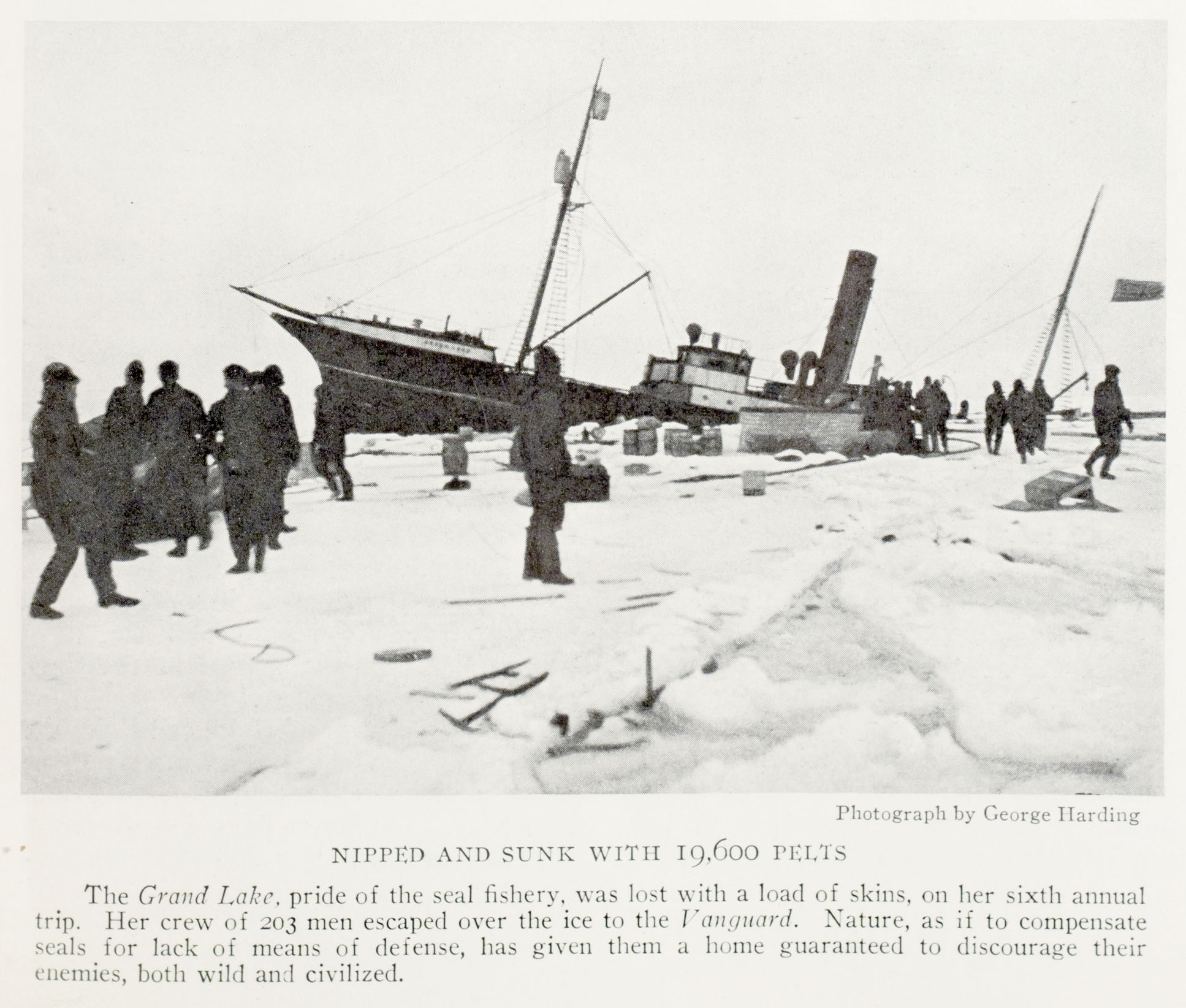
Out on the front, descending through the ice, the steam ship Grand Lake takes her load of seal pelts down to the depths. (July, 1929 National Geographic Magazine)
Icy Gambling - Newfoundland Sealing
While repairing nets and boats during down time in the winter, many men in the Freshwater Carbonear area would try and earn a bit of money and take part in the annual harp seal hunt.
The second most valuable fishery in Newfoundland, the annual seal hunt started in early March, "the worst time of the year, when gales of wind and snow are the usual thing" according to the famous sealing Captain, Robert Bartlet in 1929.
In the early 1800s, companies owning wooden sailing schooners looking to profit would sometimes purchase old and run down fishing ships from Europe and retrofit them for the ice hunt. They would hire local men for the hunt, who would try and find comfort in the storage hold of a barely seaworthy ship with no bunks, using only their clothes bag for a pillow.
In 1828, sixty ships from Carbonear, five from Freshwater, and one from Clown's Cove made up part of the Newfoundland sealing fleet with a total of 3,180 men from the Conception Bay Area, an early adopting region of the seal fishery. One of those Conception Bay residents, an early innovator, Richard Taylor of Carbonear, was known as "The Thoughtful Man" and worked to protect ships from the crushing ice by fitting wooden bows with "iron sheathing" and strengthened ship hulls with "false beams." He also divided the ships hold into "pounds" for preserving pelts and preventing shifting loads during prolonged voyages.
As ships and technology improved, steam ships were introduced in 1862 and were first made of wood and then steel. Both would be employed in the sealing industry. Steaming out of the harbor in the capitol city of St. John’s as well as outports like Harbor Grace and Carbonear, they would set off to cheering crowds along the wharf along with cannon fire, ringing bells and family well wishers praying for a quick and safe return. Despite such send-offs, the yearly event was brutal on both men and marine mammals as sealing was notoriously dangerous for Newfoundlander's, risking their lives out on the ice and on the ship to the benefit of mainly, the company.
In a sea of masts, the St. John's sealing fleet is ready to steam out of the harbor. (July, 1929 National Geographic Magazine)
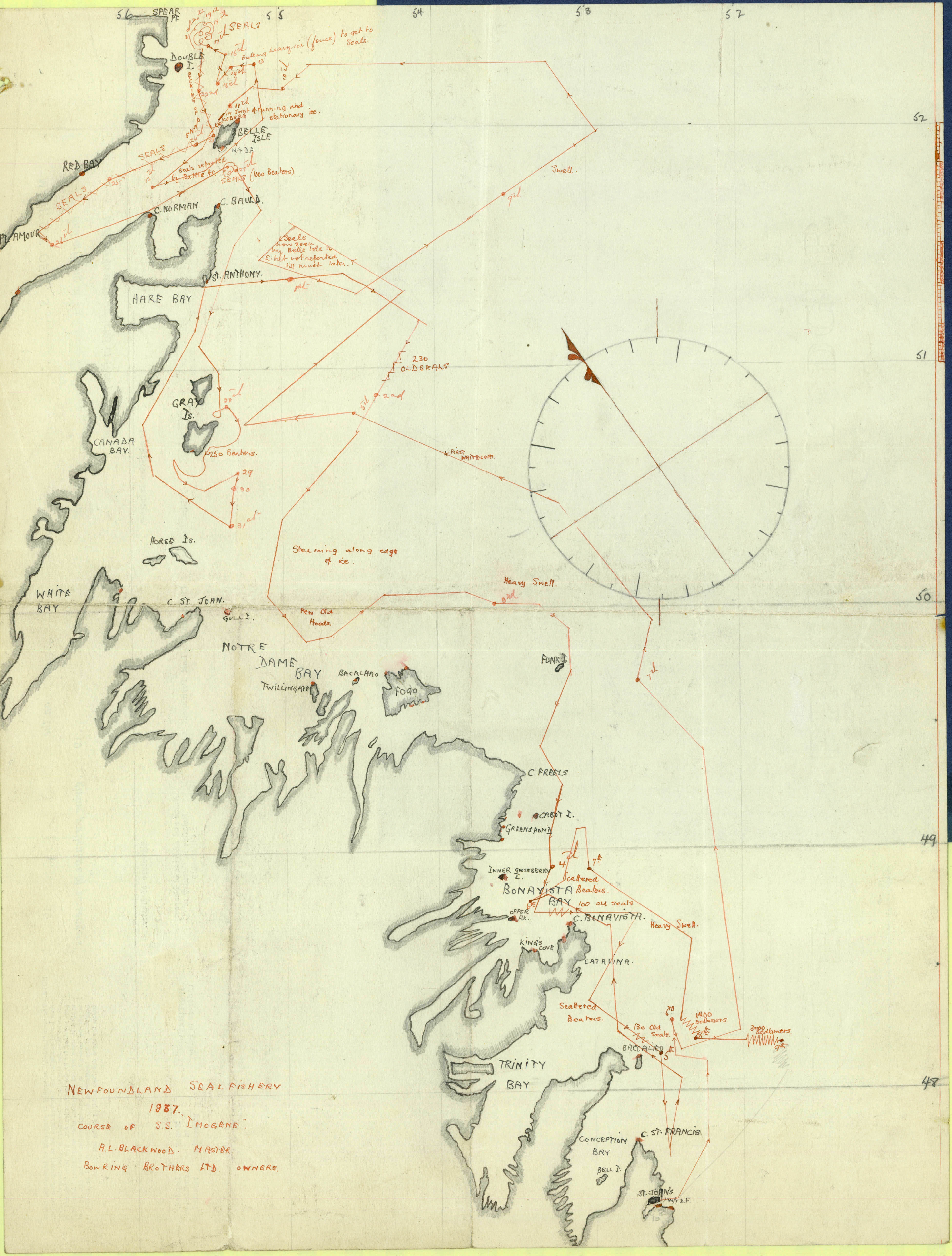
Hand drawn, a detailed map from 1937 shows the precise route of the Imogene, a sealing vessel traveling north from St. John's and wandering through the ice filled waters in search of pelts. The comprehensive report is compiled by the Bowring Brothers and accounts their sealing journey with daily entries of stowaways, difficult ice, seal locations, telegrams and news reports. (Memorial University of Newfoundland)
Leaving safe harbors, the sealing fleet would break through the ice flows from their various ports to their northern destinations, many times using dynamite to blow a passage through the ice. Even unfortunate powder explosions and fires occasionally occurred sinking a vessel. Battering winter storms and shifting loads could also sink a ship while sickness could rapidly spread throughout a crew.
If men survived the ship, they faced death on the ice while killing seals from numerous hazards. In freezing conditions, thick fog would set in and blizzards and high winds would rage for days. Other threats were constant, such as falling through the ice and drowning, frost bite, snow blindness and death from exposure as well as being lost and left behind, all for a few dollars of income. According to longtime sealing captain Bartlet, a national hero, "The chance of losing his men on the ice in a fog or blizzard is a worry that always besets a captain."
Furthermore, dangers to the fleet were ever present. Entire ships were sunk with their entire crew and thousands of pelts. Ships propellers would regularly be crushed by ice. Captain Bartlet describes "Scarcely a year went by but one or two ships were lost. The building of steel vessels and the use of wireless to receive weather reports have cut down losses in recent years." (Nat. Geo 1929 pg. 129) He continued to describe the peril:
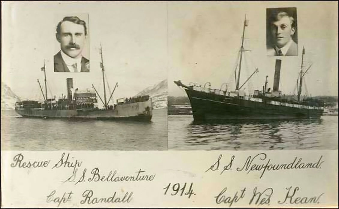
Captains and ships from the 1914 sealing disaster with the loss of 77 men. (Photo from Maritime History Archive - Public Facebook Page)
"In 1914 the fleet was all together on the front. The weather of threatening, but some captains put their men overboard, hoping that the day would end fine. But out of the northwest came a terrific blizzard. Wind and snow jammed the ships, so that they could not get to their men. Lakes of water opened between the men and vessels. In the raging storm many men fell through the cracks and froze. When the weather cleared next day the steamship Newfoundland had lost 77 men!"
For another unfortunate crew, "After making a quick pick-up of seals, the Southern Cross was almost home. Ten hours more and her crew and cargo would have been safe in St. Johns. Off Cape Pine, early in the morning, she was caught in a gale and sank with 174 men. Except for one life belt picked up on the coast of Scotland some months afterward, not even a stray bit of wreckage was ever found."
Much of the sealing process was both reckless and wasteful for both human and animal life. Hunters would strip just the seal hides off young "white coats" (pups 3-4 weeks old) and the older seals protecting the young. There was almost no market for the meat, so seal carcasses were normally left to rot on the ice. If the hide made it back to port without sinking off ice flows or spoiling in the ships hold, the fat on the hide would be rendered for lubricating oil and later and soap production. The pelts would be used for products like sealskin pocketbooks for the American market.
Sealers remove the skins. (July, 1929 National Geographic Magazine)
The seal fishery was viewed as another source to be extracted, like fish and a way to make money. Narrow viewpoints from fishermen also blamed the seals for consuming too much cod fish, when in reality, humans were and still are depleting the fish stocks through relentless over fishing. Today's veterinarians rule the seal hunt is inherently inhumane and clubbing and shooting of seals in the seal hunt fails to comply with Canada's basic animal welfare standards. Disturbingly, veterinarians found that in 42 percent of the cases they studied, there was not enough evidence of cranial injury to even guarantee unconsciousness at the time of skinning.
The toll on marine wildlife was extensive as millions of harp seals were killed for soap and sealskin products. During the peak of the Newfoundland industry in the 1850s, over 400 sailing vessels and 13,000 men worked the ice producing massive catches of 700,000 seals in one year. Sealing was not limited to Newfoundlanders, as Americans, Norwegians, Scottish, Icelanders, and much of Europe and Asia took part in the hunt below the Arctic Circle.
Outports across the Avalon Peninsula would embrace the industry and produce ships and crews for the sealing industry. Companies such as Bowring Brothers, Job Brothers & Co., Ridley & Sons, and John Rorke would build or supply ships. Men would converge on the home port, signing up as part of the sealing crew for an initial "crop" or advance. In 1929, the advance in St. John’s was $9, to be spent on supplies at the start of their journey or sent back to the family.
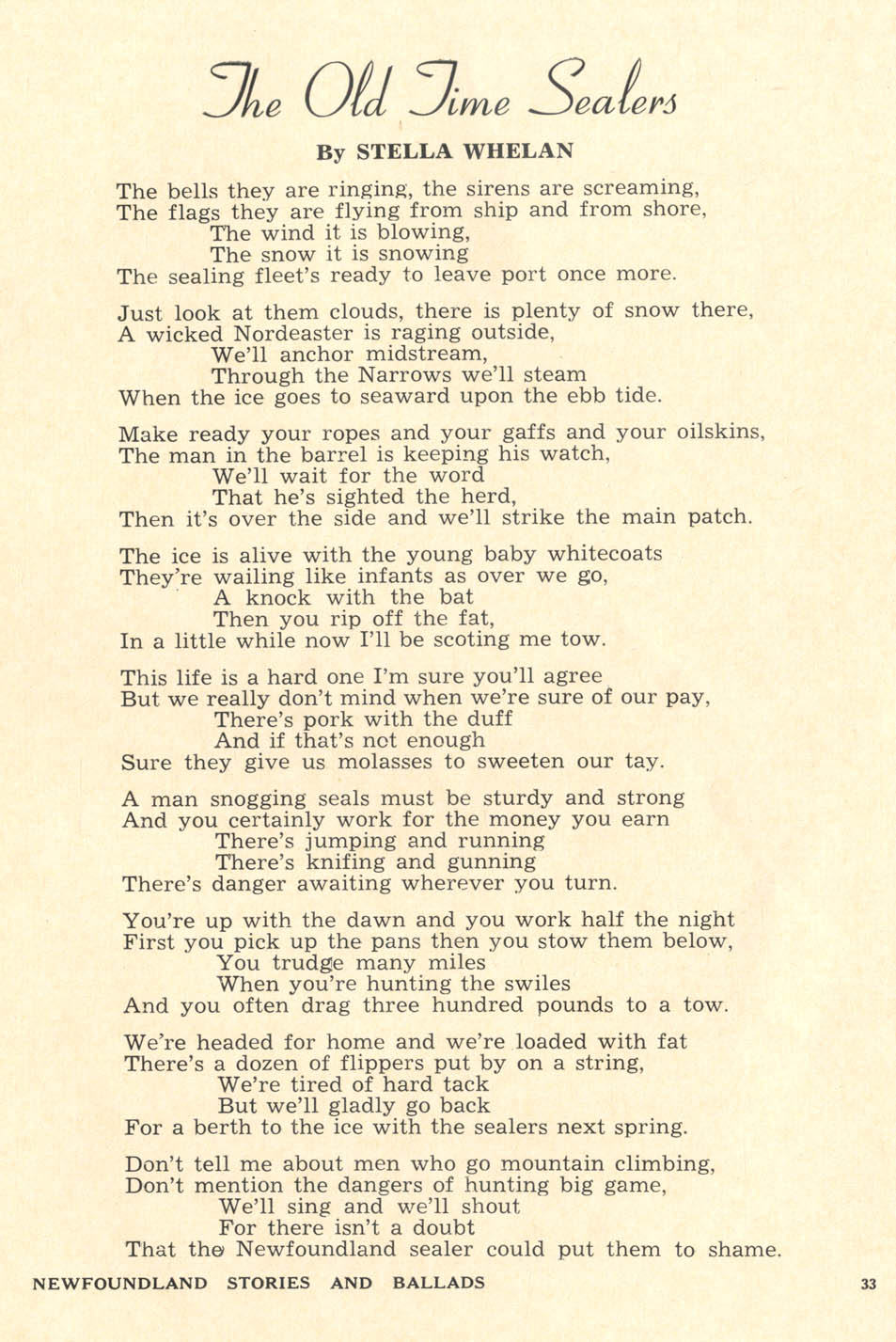
Many Davis, Moores, Pike and Parsons captained sealing vessels and undoubtedly crewed the fleet. "Only the keenly alert and active" would "qualify as hunters" as "A man snogging seals has to be light-footed, running and jumping over the ice like a deer. A big fellow with broad shoulder has to be followed around with a life belt; he will be falling into the water all the time."
Each sealer received a ticket with his number and name on it along with his advance to be repaid if seals were brought in (in 1929, a higher $12 repayment was required). Captain Bartlett describes the risky results of a hunt as potentially "grave" with small profits for the crew. "The only guarantee a sealer gets is food and a crop note, equivalent to $9. He works on shares. One-third of the net earnings is divided among the crew. That includes everybody except the captain, who gets four percent. He takes the same risk as the crew - no seals, no money." Earlier in the sealing industry, individual hunters had to pay for access for a spot on the ship.
In 1929, "Shares have run as high as $238, but the average is about $60. This is not much, but it comes at a time of the year when a little money looks good." The other two-thirds went to ship expenses and the company investors who risked only capitol, not life and limb. Most sealers knew the pay was minimal, but enjoyed the risk and adventure despite the hardship.
Nevertheless, during a 1902 sealing strike in St. John's, workers forced better wages and removed some lodging expenses, but the job was still a gamble. Despite the dangers, plenty of men, even those who narrowly escaped death in icy ship wrecks, quickly signed up for another year of sealing. Likewise, the Summer, 1914 Newfoundland Quarterly states: "The prosecution of the seal fishery off the coasts has always been and will continue to be, so long as it is carried on as at present, a highly dangerous and exciting occupation, those engaged therein being perpetually exposed to disaster and death under conditions and circumstances that would intimidate any men less daring than the hardy and intrepid sons of Newfoundland."
Native populations hunted seals for thousands of years on a small scale using nets and traps. Later, early voyagers and fishermen wrote of harvesting seals through the 1500s and 1600s. As the southward seal migration onto the ice flows was discovered, it was immediately over exploited with numerous collapses where a seal wasn’t seen for years. As technology advanced with stronger steel ships and the use of spotter planes and then helicopters, the numbers of seals declined, just like during the collapse in the cod fishery despite the lowering of seal quotas throughout the years.
Today, the hunt is largely subsidized by the Canadian and Norwegian governments with one Norwegian company purchasing close to 80% of the seal skins from Canada which it uses to produce fashion garments for export. The benefit to Newfoundlanders is minimal as the hunt accounts for less than 1 percent of Newfoundland’s economy. Canadian taxpayers, including Newfoundlanders pay millions of dollars a year for icebreakers to rescue sealing crews by the Canadian Coast Guard. Furthermore, scientists have sounded the alarm regarding the poor science used by the Canadian government to set quotas for the number of seals killed.
Historically, the sealing industry served to help the Newfoundland people despite the cost of lives to its people and wildlife. Today, the subsidized sealing industry now mainly benefits international companies and continues to deplete the Newfoundland taxpayer of hard earned funds and their waters of its wildlife. As seal numbers decline, alternatives to the seal hunt are starting to be being implemented.
One alternative with potential, is marine ecotourism, including seal watching. Viewing visitors with binoculars and clicking cameras could provide a wide distribution of income for Newfoundlanders, from guides, to boats, lodging, meals and food to expanding trips across the island. In the Magdalen Islands, one of Canada’s sealing areas, seal watching now brings in more money to local communities than seal hunting does.
Time will tell if changes can be made to the benefit of both the people and wildlife of Newfoundland.
1900 view of Freshwater, Clown's Cove and Flatrock in the distace with tolt rocks and numerous punt rowboats in Freshwater Cove. Many more stages hang off the cliffs near the wharf and school in the 1900 photo than in the 1950s photo below. (Author added color and text to original landscape photo by Robert Holloway (1850 - 1904) from The Rooms Provincial Archives - photo F 54-5)
Packed with more homes, the No. 14 photo taken by photographer C. A. Maijer shows a booming Freshwater in 1913. Workers climb on the church roof top, no doubt with endless repairs, keeping the old church going. Throughout the years, the church added wings for more space and eventually a new, larger church was constructed in 1926. Multi-level stages still line the cliffs and even show expansion from the earlier photo above. (Photo from Public Facebook group - Freshwater, C.B., Newfoundland)
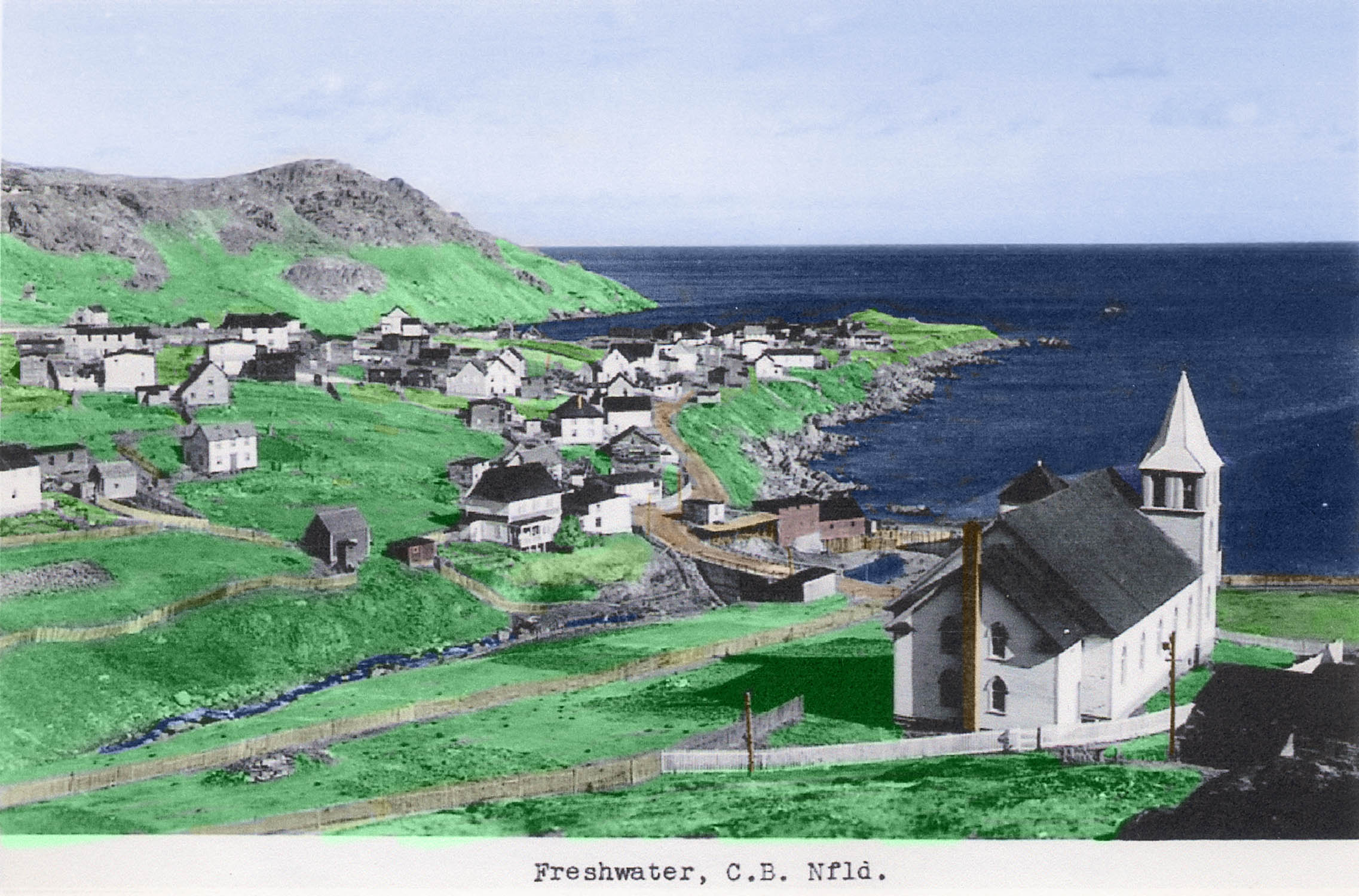
Taken about 1950 from above the Freshwater United Church (3rd version built in 1926), a pair of tall, fish storehouses stand on the wharf and numerous homes line the edge of the cliffs. However, compared to the earlier photos, there are none of the stages lining the cliffs and there are now grassy gaps where homes once stood. Telephone poles poke out behind the church and a cement bridge installed in the late 1940s replaces the old wooden one. The photo was used in the December, 1958 Newfoundland Quarterly (Added color to personal post card) Magazine from the Memorial University of Newfoundland.
Mapping History
Today, a small village of newer homes remains in Clown's Cove. A few older homes still stand, but not much material remains from the first Parsons families, except a new sign for "Parsons Lane" labeling the old dirt road. Davis, Moores and many other family names fill the quiet, Freshwater United Church Cemetery. Quite a few Parsons grave stones still stand in Carbonear, a couple of miles down from Clown's Cove. However, locating towns, coves and natural landmarks can be a challenge as they disappear and/or the names change.
Depending on what year a map was made or when a book or record was printed, many place names merged and some disappeared only to reappear later. According to a 1894 Newfoundland Directory, Carbonear isn't named, but Freshwater is.
The Parsons, Davis, Butt and Moores families were mainly living on or near Clown's Cove Head, in Freshwater, along the rocky coast, just south of the cove. The Pike Families lived north of the cove, closer to the Tolt Rocks which was considered Clown's Cove despite it being so close to Freshwater.
The name of the Clown's Cove area today is often referred to as Clements Cove or Freshwater/Carbonear, the larger populated area lying to the southwest along with a source of fresh water, Freshwater Pond, probably an early source for drinking water close to Clown's Cove and the coast. The map names through the centuries have changed and reappeared depending on what map and what language has been used which makes for chasing ancestors a bit confusing. Despite the area being a few miles in length, it can be referred to by many names like, Clouns Cove, Clown's Cove, Port de Claune, Crockers Cove, Freshwater, Carbonear, Carboniere or Freshwater/Carbonear.
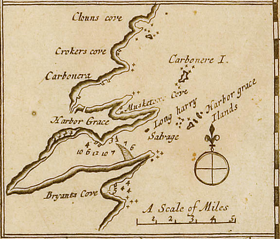
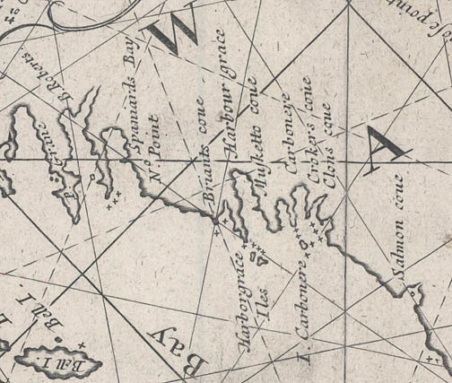
Part of an early 1698 map with 'Clouns cove' or today's Clown's Cove. Crockers cove and 'Carbonera' or Carbonear are a mapped a few miles southwest. Map from Memorial University of Newfoundland.
Drawn at an odd angle with north to the right, part of an early 1675 map has 'Clons Cove' identifed. Map from Memorial University of Newfoundland.
The top of a 1780 map has labeled 'Clouns Cove for Boats' and no labels for Freshwater or Carbonear. It has also labeled the best route past Carbonaire Island or I Carbonera. Map from Memorial University of Newfoundland.
Much more detailed, a squared off portion of a 1770-9 map shows small squares for buildings in Clowns Cove and nearby towns. Map from Memorial University of Newfoundland.
Descriptions of the Clown's Cove and Carbonear Island from the 1706 book, The English Pilot (Later versions of text are slightly different including the 1794 text in the above photo):
"Salmon-Cove to Carbonera (the Course is S.W. about 3 Leagues). The S. end of Carbonera Island is low, upon which is a Bulwark of 20 Guns, which the Merchant Men made for their Defense. The Harbor of Carbonera is very bold on both sides, so is the Island, between which and the Main are Rocks, which are just under Water. This is a good place for ships to Ride in, and for catching and curing of Fish; and several Inhabitants with good Pastorage and above 100 Head of Cattle, which afford good Milk and Butter in the Summer-time; there is very good Anchoring in clear Ground, fair turning in or out, being a Mile broad, and 3 Miles into the River, Riding in 5, 6, 7, 8 fathom or deeper Water if you please. But to the Northernmost of these 2 Coves is called Clownes-Cove, not for ships, but good for Boats, being above 2 Miles from Carbonera; the other is called Crockers-Cove, where live two Families, is but a little to the Northward of the entrance of Carbonera (Bay or) Port."
Sir Johns Berry's Census of 1675 had one planter family, Joseph Parsons at Clown's Cove and two, Roger Butt and Bartho Keys families at the nearby Crocker's Cove. Similarly, the three houses are shown on the 1706 map with corresponding text which was likely acquired from earlier voyages in the late 1600s. The, piers and points, rocks and islands of Carbonear and Harbor Grace also match the geography of later maps. The 1706 map seems to be an early snapshot back in time showing the location of many of the early settlers or planters in the area.
17th century settlements in Conception Bay - Peter Pope - Memorial University
...The aim of the 1986 Conception Bay Survey was to further the task of creating an inventory of Early Modern settlement sites in Newfoundland. By 1675 there were settlements all along the English Shore, that is the coast between Trepassey and Bonavista (Berry 1675).
This Bay was dominated commercially by a different part of England's West Country than Ferryland, where the Memorial University Archaeology Unit has been excavating under the direction of Dr. James Tuck (this volume). Because Conception Bay trade links were with Bristol, Dartmouth and the Channel Islands rather than the North Devon ports that dominated the southern Avalon (Matthews 1968: 185), we might expect a slightly different assemblage of material culture. The comparison is of interest for the North Devon ports exported ceramics widely (Grant 1983) and it would be useful to have some idea of the proportion of their wares at a Newfoundland harbour dominated commercially by other English ports...
Excavation Results - Clown’s Cove
Buildings and wharves indicated on the early maps drew our attention to one end of the barachois beach at Clown’s Cove (Figure 10). We located a niche cut into a sloping hillside and shovel tests in this area produced seventeenth century material. The niche is about the size of a small house, with its longer side facing the cove. The Early Modern artifacts recovered seem to be distributed in a fan-shaped array spreading out downhill from the niche. The concentration of artifacts is not nearly as dense as at Bristol’s Hop, not is the soil nearly as deep. On the other hand the artifacts recovered are generally less worn and fragmented by cultivation.
The sample of pipe stems recovered is not large enough to be very persuasive statistically (n=41) and the mean pipe stem bore date of 1665 (Hanson date range 1620-1750, Oswald 1975: 92) should be considered very cautiously. The presence of case bottle sherds suggests that some kind of occupation did commence before 1675. Two of the pipe bowls are identifiable stylistically as Oswald Type 9 or 20 (1680-1710 or 1690-1730). One pipe bowl base is marked with single punctate dots on either side of the base (Figures 11 and 12). Such dot-marked bases were produced in Exeter ca. 1700-1730 (Fairclough 1978: 115).
The ceramic assemblage is, like the Bristol’s Hope assemblage, a typical seventeenth century one which could have been supplied from a number of West Country Ports. The vessel forms are typical of those in use in Newfoundland among planters:
1 North Devon Smooth CEW ?Plate (1600-1725)
1 North Devon or South Somerset CEW ?Plate (1600-1800)
1 North Devon Gravel Temper Milk Pan (1450 - 1750)
1 South West (?) Micaceous CEW Bowl (1500 - ) (Figure 13)
2 Merida Bottles (1300 - 1950)
1 Iberian (?) Tin Glazed Bowl (1500 - ?) (figure 14)
1 Tin Glazed Plate, blue and magenta decorated
1 Tin Glazed Cup or Jug, blue decorated (Figure 15 (drawing not in PDF))
The artifacts recovered at Clown’s Cove do not seem to represent as intensive or as enduring an occupation as our finds at Bristol’s Hope (On early maps as Mosquito). With the exception of the case bottle fragments, what our tests uncovered could be accounted for by an occupation by a single planter household for a few years in the period between 1680 and 1720.
Discussion
The location of two Early Modern sites in Conception Bay, in the course of a short survey, indicated a number of things. First the results underline the usefulness of early maps in locating historic period sites, even if the maps somewhat postdate the period under investigation. There are other maps which could be used to assist the survey of other portions of the English Shore.
Second, there is something to be learned, I would argue, from the very comparable situation of these two sites. Each is at one end of a barachois beach, just inside the barachois within a few meters elevation from the water. Nor is this limited distribution merely a result of our survey approach: we tested many other locations. These sites could even be compared to the Ferryland sites, which are located at one end of a beach within a few meters of salt water. Such sites were, it would seem, the first choice of the early residents of Newfoundland - for very practical reasons.
Finally, the results of the Conception Bay Survey confirm that some of Newfoundland’s Early Modern sites remain relatively undisturbed, especially in smaller communities. Such communities, coincidentally, might most benefit from and be most appropriate for suitable development of the province’s Early Modern historic resources.
Small Town Life
A rare snapshot listing some of the hard working residents in Freshwater and Clown's Cove during May of 1913 performing road maintenance to the Freshwater and Plank Roads (80 Feet Plank 3 cents per foot - total $2.40). Dirt roads needed constant maintenance, especially after the winter or wet seasons when muddy ruts would form. See original photo. From public Facebook group Freshwater, C.B., Newfoundland
The photo taken in 1924 shows Freshwater's Plank Lane. George and William Davis installed planks on their property over the creek bed which also passed between the Hayward Marshall and Hubert Davis homes in Freshwater. The narrow avenue, just west of Parsons Lane, rolls out towards Freshwater Cove, Maiden and Carbonear Islands. According to locals, residents would haul their wooden fishing boats down over the planks. The wooden roadway was constructed at least by 1913 with listed expenditures showing 80 feet of plank. (Photo from Charles Davis via public Facebook group Freshwater, C.B., Newfoundland) Color version by author.
Living along Plank Lane, more Davis relatives. On the far right, Ebenezar Davis (1852-1925) holds the horse bridal while his grandson, Mark Beatson Davis (1904-1985) rides horseback and his wife Sarah Lillias Davis (1857-1935) stands in the doorway of their home around 1908. The west facing home had a "widows walk" on top of the home where an expectant wife would keep an eye out for their husbands off at sea. According to relatives, the "Davis's built boats near by, back in the day and dragged them down over the planks of plank lane. The Davis family built, constrquot; From public Facebook group Freshwater, C.B., Newfounucted the first planks there. The path would often wash out, hence the planks.
In the 1940s, Freshwater locals hang out at the new bridge in front of the Andrew and Elizabeth Parsons home and workshop. Rueben Noel, a truck driver earlier in his employment, stands on the left, a taller Steven Parsons stands in the middle and perhaps Heubert Davis on the right.
The Parsons workshop, standing behind the car, was a twine loft used by Andrew Parsons, Gord Penney and Mr. Butt to mend fishing nets and traps. For years, early residents, while waiting for the bus, would wait in the "shop" if the weather was bad. One neighbor remembers it was never locked and smelled of "barked" twine, a pine preservative used extend the life of the nets. The little hill adjacent to the "shop" was known as Shop Hill.
About the same time, Eugene Parsons and Francis (Frank) Davis walk past the new cement bridge which replaced the old wooden bridge, at the bottom of Church Hill. In the background along the road stands once again, the home and adjacent workshop of Andrew Parsons who lived next door to Eugene.
Barking kettle and net in Freshwater along the creek. In the traditional "barking" process, buds and bark from spruce, fir and conifer trees would be added to a large, iron cauldron filled with water called a "barking kettle" or "barking pot" and set over a fire to boil. After several hours, sails and fishing nets would then be submerged in the boiling mixture of dissolved pines, now containing myrrh and turpentine, for about thirty minutes and then removed, spread and out on fences, rocks or wharves to dry. The dark liquid served as a piney preservative, coating twine nets and sail material, resisting mildew, rot, fungi, marine organisms and the general corrosive effects of the sea. Similar treatments would be used for sealskin boots and fisherman's clothing and even barked burlap was used in traditional hooked rugs. (Photos from Public Facebook group - Freshwater, C.B., Newfoundland)
Fisherman living north of Conception Bay "barking" their cod trap net at Lumsden North in 1964. Photo from Memorial University of Newfoundland
Standing under the Clown's Cove Tolt, the Reuben Pike family home pictured in the 1940s still stands today overlooking the beaches and once busy cove. The Pike family owned much of the land in Clown's Cove and had many codfish stages, flakes and storage buildings as well as a cod liver oil business well into the 1920s.
According to the 1805 Plantation Records, Francis, Samuel and Edward Pike owned Room #954 with two houses, two gardens, two meadows as well as one beach with one stage, and two flakes in 1800. The two homes would also multiply onto the tolt as more Freshwater families would marry into the Pike family expanding their fish empire. Unfortunately, the depression and the numerous fish collapses took their toll on the entire area including the Pike family, resulting in a clearing of almost the entire cove of stages and fish preparation. (Photos from Public Facebook group - Freshwater, C.B., Newfoundland)
Holding a shotgun and ready for the hunt, Ben Davis stands in front of Reuben Pike's home under the Clown's Cove Tolt, likely ready to board a boat in the cove. According to an relative, Geoff Davis, the photo was probably taken in the early 1930s and he is likely ready to hunt "turrs and bull birds." Goeoff continued: "I’m assuming he was with someone and they had a boat, so were headed out on the water. He certainly hunted partridge as well… we had a couple of hunting dogs growing up."
In Newfoundland slang, a "turr" is a murre and a "bull bird" is a nickname for a Dovekie, owing to its sturdy appearance. According to Newfoundland lore, the murre, when prepared for the pot, "weigh only about two pounds each, they take two or three hours of roasting before they are tender. One local joke is that you put a turr and a rock into a pot, and when the rock is soft, you know the turr is done." (New York Times 2016 article)
The 1930s Depression years were tough on Newfoundlanders and they had to supplement their meager winter diets with "fresh meat on the wing." Another Newfoundlander, George Butt mentioned hunters would often haul up their small boat or punt on the shoreline overnight and keep it out of sight while on the hunt next morning. He continued:
"They’d hunt from concealed locations, possibly the Sounds and get there by boat. There were no outboard motors so they likely rowed so pursuit was out of the question and stealth was everything. My father often described hiding overnight in shoreline locations frequented by ducks, waiting for daylight when they move in closer for a shot. There was a lot riding on hunting sea birds as they often meant the difference between dinner and nothing at all."
In the other photo, Sophie Pike stands at her home with flowers next to Reuben Pike's home, also with the Clown's Cove tolt or mountain in the background. The face of the "Clown" in the rock sits just above her shoulder to the right of the house. (Photos from Public Facebook group - Freshwater, C.B., Newfoundland)
Early sping pack ice rolls in from the north and Greenland during the 1960s. (Photos from Public Facebook group - Freshwater, C.B., Newfoundland)
Standing under a snowy Clown's Cove Tolt, a hand full of Pike family homes stand near the ice filled waters.
On the south side of the cove, the Butt and later Noel homestead stood east of the Orange Lodge and Graham Butt's home. The two story shed housed the Butt family horse drawn carriage and later Model T Ford. There was also a vegetable and fruit store (storage building) located on their property. (Photos from Public Facebook group - Freshwater, C.B., Newfoundland)
With a few small boats in the cove, a 1948 aerial image shows Clown's Cove and surrounding community with the large school building at the far right of the photo. A winter view of Clown's Cove Tolt in 1959 shows the Pike family homes clustered in the distance on the right side of the photo and homes off the Main Road east of Parsons Lane in the center and left side. (Photos from Public Facebook group - Freshwater, C.B., Newfoundland)
Useful for storing vegetables and canned foods, a few underground storage cellars remain in various states of preservation in Freshwater and Clown's Cove. One resident commented about visiting a cellar "I remember going there with my mom to get vegetables they stored away for the winter." The cellar photographed in the middle was on the Rueben Pike family property and the photograph on the right was near the property of one of the many Parsons families. (Photos from Public Facebook group - Freshwater, C.B., Newfoundland)
An amazing piece of early Clown's Cove / Freshwater history, a muzzle loaded long rifle inscribed with "C MOORES 1850" and "JOSEPH MOORSE" on the shoulder stock. The gun was likely a British made sealing rifle without trigger guards, allowing it to be fired with gloves or mittens.
According to George Butt:
"It's been around a long time and there’s plenty of speculation as to it’s use. It’s doubtful it was ever used for sealing as it was muzzle loaded with shot (the powder horn and shot bag were at the house as well but have long disappeared). I know with certainty it was used to hunt sea birds as my father often described to me how he and his brothers struggled to hold it for sighting because of its weight, and would tie the muzzle to the gunnels of the punt, or, if firing from land, to a fence post or whatever was close for support."
Another family member, Belinda Butt comments "The man holding the long gun was my father-in-law, he was born in Freshwater on the Head. The rifle was used by his father exactly as you said, for sealing." (Photos and comments from Public Facebook group - Freshwater, C.B., Newfoundland)
Early 1960s life in Clown's Cove and Freshwater is captured in frame grabs from old 8mm films of the Butt and Davis families, from harvesting potatoes to going out on a partridge hunting party in the barrens along the Witless Bay Line (later the Trans Canada Highway). (Photos from Public Facebook group - Freshwater, C.B., Newfoundland)
Carved into a small piece of wood, "GEORGE W PARSON - FRESHWATER OF J". There was a George William Parsons born in nearby Otterbury October 4, 1891, with his grave in Freshwater dated September 14, 1947. His father was James Henry Parsons, who was also born in Otterbury on March 23, 1861. In addition, George W. Parsons was listed on the donations page for the 1906-7 Freshwater Circuit subscription for ministers salary. (Photos from Public Facebook group - Freshwater, C.B., Newfoundland)
Still standing, a couple of early, overturned 1910s galvanized steel funnels from a Clown's Cove cod liver oil factory remain in a yard of a Freshwater resident, held together with rusted bolts (sadly disposed of in 2018).
On a weathered piece of paper, residents of Flatrock, Blow Me Down, Freshwater and Clown's Cove are listed on a donations page for the 1906-7 Freshwater Circuit subscription for ministers salary. (Photos from Public Facebook group - Freshwater, C.B., Newfoundland)
An interesting Newfoundland - Freshwater superstition - My great grandmother Bertha Davis Parsons took a photo of W. J. Moore's coal shed with "good luck" circles painted on the doors. The 1947 magazine page, Around Newfoundland with a camera : a pictorial souvenir of the crossroads of the Atlantic is from the Memorial University of Newfoundland.
Freshwater also had it's share of superstitions and folklore. According to one resident, the sound of drummers would travel across the water on foggy nights. The drummers played as a doomed ship and its crew sank beneath the waves out in the sound. "The drummers - terrifying things they were - playing the drums while the ship and all went down.....You could hear them sometimes - but only on foggy nights....I think that's why people called the sound - the Sound. Ma used to say there were a lot of ghosts in Freshwater." Another resident wrote "My Grandmother Butt hears the drums first when she moved to Freshwater. She had never heard about them and became very upset because she thought there was a boat in trouble. Then my grandfather had to tell her the story. Great story!" (Freshwater Facebook posts)
Author's watercolor painting portraying the stormy 1840 shipwreck of the Nora Criena in rough seas hitting the rocks off Clown's Cove head.
In the past centuries, a number of shipwrecks and even rescues have occurred off the rocks of Maiden, Clement's Cove Rock and Carbonear Islands. On November 21, 1840, it was reported that the Nora Creina, a two masted mail boat was trying to get home to Carbonear, sailing through heavy storms and darkness only to hit Clement's Cove Rock. With heavy winds pushing from the east, the captain in an attempt to avoid the rocks around Carbonear Island sailed too far north and hit the rocks off Clement's Cove Head (Clown's Cove Head) with the unfortunate loss of life.
In addition, more than 7,000 wrecks line the coast of Newfoundland.
Other locals had family members hear the drums, and one long time resident, Ted Noel, who built his house in Carbonear in 1945, mentions the "Legend of the Hollies" where the sound of groaning shipwrecks and voices from the past drift off the water. (Memorial University of Newfoundland interview)
There was the fear of rock slides from the nearby tolt and the childhood fear of the neighbors dark cellars as they passed by during the night time hours. "My biggest fear was going up Plank Lane and passing Feltham's cellar, it was haunted, you know.....seems silly now. But, even now when I walk up Plank Lane, I still look to where the cellar used to be." (Freshwater Facebook post)
Wandering cows and horses during the night also spooked many residents as "they roamed back then and you could trip over them in the dark. They would sleep in the middle of road. I was terrified of them, even though my father always owned a horse and I too have had nightmares about them." (Freshwater Facebook post)
Boats were the key to survival in Newfoundland outports, whether it was a small fishing punt full of fish or the banking schooner delivering people and packages from close and distant ports. Busy with activity, fishermen, residents, sailors, passengers and dock workers shuffle supplies and goods on the Freshwater Cove wharf about 1900. Maiden Island and a distant Carbonear Island float in the background of Conception Bay. Fisherman's boats bounce in light rippling waves as a stiff breeze blows the British flag atop the mainmast of the "Belle of the Bay," a fishing schooner transferring people and cargo on the clear day. Bulky wooden barrels, likely filled with cod liver oil or perhaps flour would be rolled to and from the ship as intermingling voices, with the sound of boots and dropped boxes thumping on the weathered wharf and the clanking of rigging would echo through the air filled with the smell of the ocean and cod fish.
The 39 ton ship built in 1899 in Exploits, Newfoundland was owned by a trader and dealer, Thomas Windsor. She lasted through 20 years of annual fishing off the coast of Labrador and survived a close call in 1912 where in high seas she hit projecting rocks and sheered away the masthead iron. Eventually, in 1920 she broke up near Cape Broyle, Newfoundland. (Photo from Memorial University of NFLD Maritime History Archive)
Looking southeast over Conception Bay, the above photo was taken in June, 1957. The largest, two story building left of center was the three room Freshwater UC (United Church) School with a courthouse on the second floor as well as the telegraph office in the early days.
The two story home and shop right next door was initially owned by a merchant, Mr. Moores and later, in 1957 by Henry and Sophie Butt with the attached, small one story shop with the smoking chimney pipe which remained in business into the mid 1960s. George Thoms shop was across the street and outlasted Butt's shop. Gus Oates home was on the far right with their shed or barn-like storage building, many times referred to as a "store" by Newfoundlanders and nearby outbuilding on their property behind the house. The store, would be used many times for prepared fish or fishing gear including nets and cod traps.
Some of Freshwater's school teachers during the years 1951 to 1958, were Miss Snow (kindergarten - 1st grade) Jean Howell, Shirley Somers, Emmie Morey (4th grade), Emily Humby (5th grade), Clayton Peach, William (Bill) Butt (who was born under the Clown’s Cove Tolt), Evan Hefford (7th grade) and John Davis (8th grade). There were three classrooms overseen by Principal Mr. Boyd Trask and followed by Mr. Clayton Peach, who remained there until the new UC Regional High School opened in Carbonear in 1960, where grades 9 through 11 attended the school initially and where students were bused to from Freshwater. The old Freshwater UC School students attended primer (transitional year between kindergarten and 1st grade) through grade 11 classes. (Photo from public Facebook group Freshwater, C.B.,Newfoundland)
Looking over a rather desolate Clown's Cove Head, the above photo was taken about 1965. The Orange Lodge built in 1911 stands almost hidden on the far right. The school lost its second story and no stages or sheds stand on the cove. The Eli Davis house stood far out on the head. The population of Freshwater was at or almost at its lowest point in history. According to the 1971 Census, the Freshwater population was 147 people. (Photo from public Facebook group Freshwater, C.B.,Newfoundland)
In a double exposure taken about 1965, the Freshwater United Church, built in 1926 and the cemetery stands on the high ground. Carbonear Island stands in the distance. Homes line the coast of Freshwater Cove at the base of Church Hill and climb the rocky Freshwater Tolt. (Photo from public Facebook group Freshwater, C.B.,Newfoundland)
In 2006, we explored the Freshwater and Clown's Cove area with local historian, Bert Parsons and Freshwater residents, Graham Butt and Clarence Parsons. Graham pointed out the clown in the cliffs and where the William Davis home once stood. Bert and Graham both talked about the W & J Moores fish storage area. This is some of the video (7 min) from their most helpful tour.
Further preserving the names and history of Freshwater,
Herman Butt wrote the following poem in April of 2011
The Merchants of Freshwater
There’s a little town in Conception Bay
That was very prosperous in its hay day
There were more than twenty Businesses in town.
I’ll tell you now who owned them
and where they were found.
Reuben and Jake Parsons had a Cod Liver Oil Factory
on the Beach. If you needed some for what ails you,
it was in easy reach.
Further up the road Walter Pike would sell coal for 100 weight a Buck
If you wanted some to heat your home
you could go and pick it up.
Freeman and Reg Noel had a Sawmill, a little further on
they sawed wood for the local people,
to build their Houses, Boats and Barns.
Ralph Noel had a Turkey farm. Where he raised Turkeys for a living.
You could get one anytime, for Christmas or Thanksgiving.
This farm still operated today, you can find it
on Freshwater Road, just off the main Highway.
Joe and William Noel ran a Bus and Taxi service from here.
You could get a ride up the Harbor for very reasonable fare.
They are known today as Noels Motor and Transit services
on Saddle Hill in Carbonear.
At the foot of the pond, Jack Broderick ran a
Forge and Blacksmith shop.
He made Shoes and Shod Horses every day
so people could haul their wood and hay.
The Church kept a Parsonage for the Minister to stay.
In later years they sold it to Jack Butt.
Where it’s still lived in today.
The undertakers stood at the to of the hill.
Thats where Billy C. Noel handled Funerals
and made Caskets to sell.
A family run Business that’s very well known.
Today it is called Noels Funeral Home.
Now, over the cove Minnie Bowers ran the Post Office.
She worked hard every day without fail.
She helped people post their parcels and letters
and passed out their mail.
Wallace Snow took care of the towns sanitation
He picked up the garbage and took it to its destination,
Up over the hill to the town dump
Where it was burned and all covered up.
Now the place that’s called Plank Lane today,
was made by Hayward Marshall and Shenstone Parsons.
They put the road through, they laid down the clay.
There were a good many Shopkeepers in the day and time
I’m not sure how many, but I think there were nine.
There was Andrew and Freeman Parsons,
Ben and Frank Moores too
George Thomas and Henry Butt,
just to name a few.
Sam Moores, John Parsons and Bill Hillyard also
lets not forget Hal Snow, he was the last one to go.
Many years later a few small stores reappeared
by then, most did their shopping in Carbonear.
My son, Paul had a small shop
in the basement of his home.
Roland Snow and Wayne Penney had theirs
over the cove.
All these Stores are closed now,
there’s not a single one left there
The closest one is Burdens Red Circle
on Water Street in Carbonear.
Freshwater will always be a special place to me
You see, I was born and raised in Flatrocks
a nearby Community.
This was the place to go for our necessities.
My memories are fond ones and will always be.
Hail to Freshwater a quaint little town by the sea.
Herman Butt
April 2011
------
In response to Herman's poem, a Parsons relative wrote "Thank you for posting this, my grandfather Broderick was the blacksmith you mentioned. He also made barrels for the fish and fish oil. A Cooper, blacksmith, you name it he did it, he made wrought iron gates, hinges, all sorts of tools, you needed something made out of iron he did it for you."
(Poem and reply from Public Facebook group - Freshwater, C.B., Newfoundland)
The small community of Flatrock in 1952 just east of Clown's Cove and Herman Butt's home town. (Public Facebook group - Freshwater, C.B. Newfoundland)
In July of 2006, only overgrown tracks and a few boards remain of the community that was once Flatrock, adjacent to Clown's Cove. The foggy view was photographed from the top of Clown's Cove Tolt looking east. Many of the homes were nestled around the cliffs in the upper left of the photograph. (Dave Parsons photo)
Video Description: Just a stones throw from the town of Flatrock, starting on top of windy Clown's Cove Tolt rocks, the video below, taken on a 2006 trip, shows the view out to Conception Bay with Carbonear Island, Maiden or Maidenaire Island, and looks over Clown's Cove and Freshwater and eventually explores Parsons lane and adjacent Plank Lane. The video also shows the empty lot where William Davis' and Jane Moores (my Great, Great Grandparents) house once stood on Main Road, the continues to show Clown's Cove with the 'Clown's face' on the tolt side cliffs and the Freshwater Cemetery with the wife of Eli Davis, Jane Davis' grave stone and old restored Davis House.
The well worn photo is taken close to where the Davis family lived on Main Road in Clown's Cove, Newfoundland. The steep hills or Clown's Cove Tolt stand north of the cove and have a path running up and over to the small village of "Flat Rock." The little pond below the homes would dry up during the summer months. Fish tie ups are on the right of the photo along the shore behind more homes.
This photo is looking south towards Maiden or Maidenaire Island. Carbonear Island is on the left horizon and on the right horizon is Mosquito Point. The buildings belonged to W. J. Moores - the low one on the left is a coal shed and other was for their fish storage. The rock in the center of the photo still remains to this day just off Clements Road.
Again just off Main Road, looking south-west at the long wharf with fish stages. In the foreground, bundles or piles of fish are stacked ready to be spread out and dried on the stage overlooking the waters of Freshwater Cove.
Hand forged, wrought iron cemetery plot fence stands just north of the church. It was most likely made by a family member and important enough to photograph in 1929 by Bertha Davis Parsons.
Bertha Davis Parsons stands near her parents home at Freshwater Clown's Cove just off Main Road.
Bertha then takes a photo of her son, James T. Parsons Jr.while visiting the Davis family.
The historic Freshwater United Church was built in 1926 and stands in between homes in Freshwater and Clown's Cove with a fisherman's boat in the foreground.
The above photos were taken in 1929 by Bertha Davis Parsons when she traveled from Massachusetts back to her childhood home with her son, James. A few Clown's Cove homes still remain the same and the hilly scenery has not changed much either. See photos of what Clown's Cove looked like in 2006.
Long time Freshwater resident Nicholas Parsons eventually migrated to the U.S. in 1899 with his sons where the family had a portrait drawn from a photograph. The studio photograph was taken by Putnam in Chelsea, Massachusetts about 1903 with James T. Parsons Sr. on the left and Nicholas Nichole Parsons, his father, on the right. Notice the "X" made above Nicholas by the artist marking the correct person to make the drawing of.
The portrait is a sun enlargement photo made by projecting a glass negative onto light-sensitive paper using sunlight focused through a lens, then hand-enhancing the low-contrast print with pastels, watercolors, or oils to create a "crayon portrait." The technique was popular in the late 19th and early 20th centuries. They are also known as a charcoal portrait, sketch portrait or pastel photo. Putnam photographers on 462 Broadway in Chelsea likely took the cabinet card negative and enlarged the photo on a salt print and added pastel, watercolor and charcoal to enhance the photo. The original frame still has its old glass with bubbles and numerous defects.
Visit the nearby town of Carbonear, just west of Freshwater - a focus for employment, industry and household needs. Also, further southwest, the early town of Harbor Grace.